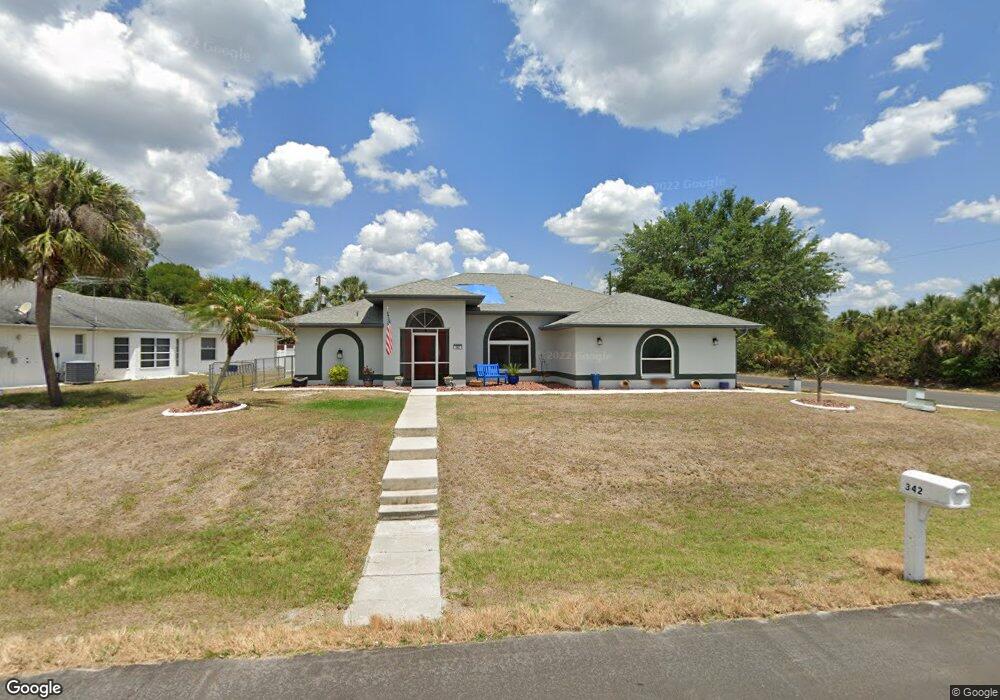
342 Camden Ln Port Charlotte, FL 33953
Northwest Port Charlotte NeighborhoodEstimated Value: $358,000 - $534,000
3
Beds
2
Baths
1,967
Sq Ft
$216/Sq Ft
Est. Value
About This Home
This home is located at 342 Camden Ln, Port Charlotte, FL 33953 and is currently estimated at $425,371, approximately $216 per square foot. 342 Camden Ln is a home located in Charlotte County with nearby schools including Liberty Elementary School, Murdock Middle School, and Port Charlotte High School.
Ownership History
Date
Name
Owned For
Owner Type
Purchase Details
Closed on
Jun 6, 2025
Sold by
Schmidt Selina P
Bought by
Schmidt Selina P and Esparra Katrina D
Current Estimated Value
Purchase Details
Closed on
May 19, 2005
Sold by
Pagnotta Albert and Pagnotta Joan
Bought by
Schmidt David A and Schmidt Selina P
Home Financials for this Owner
Home Financials are based on the most recent Mortgage that was taken out on this home.
Original Mortgage
$215,900
Interest Rate
5.8%
Mortgage Type
Fannie Mae Freddie Mac
Purchase Details
Closed on
Oct 8, 1997
Sold by
Fl Lot Inc
Bought by
Pagnotta Albert and Pagnotta Joan
Create a Home Valuation Report for This Property
The Home Valuation Report is an in-depth analysis detailing your home's value as well as a comparison with similar homes in the area
Home Values in the Area
Average Home Value in this Area
Purchase History
| Date | Buyer | Sale Price | Title Company |
|---|---|---|---|
| Schmidt Selina P | $100 | None Listed On Document | |
| Schmidt David A | $269,900 | Executive Title Ins Svcs Inc | |
| Pagnotta Albert | $3,000 | -- |
Source: Public Records
Mortgage History
| Date | Status | Borrower | Loan Amount |
|---|---|---|---|
| Previous Owner | Schmidt David A | $215,900 |
Source: Public Records
Tax History Compared to Growth
Tax History
| Year | Tax Paid | Tax Assessment Tax Assessment Total Assessment is a certain percentage of the fair market value that is determined by local assessors to be the total taxable value of land and additions on the property. | Land | Improvement |
|---|---|---|---|---|
| 2024 | $2,293 | $144,680 | -- | -- |
| 2023 | $2,293 | $140,466 | $0 | $0 |
| 2022 | $2,276 | $136,375 | $0 | $0 |
| 2021 | $2,264 | $132,403 | $0 | $0 |
| 2020 | $2,214 | $130,575 | $0 | $0 |
| 2019 | $2,122 | $127,639 | $0 | $0 |
| 2018 | $1,953 | $125,259 | $0 | $0 |
| 2017 | $1,931 | $122,683 | $0 | $0 |
| 2016 | $1,916 | $120,160 | $0 | $0 |
| 2015 | $1,906 | $119,325 | $0 | $0 |
| 2014 | $1,787 | $118,378 | $0 | $0 |
Source: Public Records
Map
Nearby Homes
- 434 Lomond Dr
- 320 Yule St
- 311 Yule St
- 474 Lomond Dr
- 147 Adalia Terrace
- 1008 Adalia Terrace
- 1457 Adalia Terrace
- 1569 Adalia Terrace
- 332 La Playa Ln
- 291 Tamiami Trail
- 305 Mowl St
- 313 Mowl St
- 15193 Wymore Ave
- 355 Tamiami Trail
- 327 Tenk St
- 284 La Playa Ln
- 365 La Playa Ln
- 260 Lomond Dr
- 15172 Mcgraw Ave
- 183 Bamboo Dr Unit B