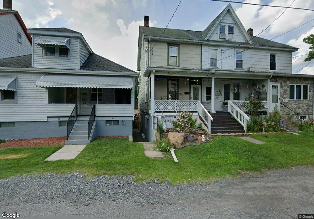
342 Coal St Nesquehoning, PA 18240
Estimated Value: $78,259 - $125,000
3
Beds
1
Bath
1,676
Sq Ft
$58/Sq Ft
Est. Value
About This Home
This home is located at 342 Coal St, Nesquehoning, PA 18240 and is currently estimated at $96,565, approximately $57 per square foot. 342 Coal St is a home located in Carbon County with nearby schools including Panther Valley Elementary School, Panther Valley Intermediate School, and Panther Valley Junior/Senior High School.
Ownership History
Date
Name
Owned For
Owner Type
Purchase Details
Closed on
Jul 27, 2011
Sold by
Porambo Nancy M
Bought by
Mcdonald Edward
Current Estimated Value
Home Financials for this Owner
Home Financials are based on the most recent Mortgage that was taken out on this home.
Original Mortgage
$44,833
Outstanding Balance
$31,301
Interest Rate
4.75%
Mortgage Type
FHA
Estimated Equity
$65,264
Create a Home Valuation Report for This Property
The Home Valuation Report is an in-depth analysis detailing your home's value as well as a comparison with similar homes in the area
Home Values in the Area
Average Home Value in this Area
Purchase History
| Date | Buyer | Sale Price | Title Company |
|---|---|---|---|
| Mcdonald Edward | $46,000 | None Available |
Source: Public Records
Mortgage History
| Date | Status | Borrower | Loan Amount |
|---|---|---|---|
| Open | Mcdonald Edward | $44,833 |
Source: Public Records
Tax History
| Year | Tax Paid | Tax Assessment Tax Assessment Total Assessment is a certain percentage of the fair market value that is determined by local assessors to be the total taxable value of land and additions on the property. | Land | Improvement |
|---|---|---|---|---|
| 2025 | $1,370 | $14,500 | $4,050 | $10,450 |
| 2024 | $1,426 | $14,500 | $4,050 | $10,450 |
| 2023 | $1,397 | $14,500 | $4,050 | $10,450 |
| 2022 | $1,406 | $14,500 | $4,050 | $10,450 |
| 2021 | $1,406 | $14,500 | $4,050 | $10,450 |
| 2020 | $1,385 | $14,500 | $4,050 | $10,450 |
| 2019 | $1,305 | $14,500 | $4,050 | $10,450 |
| 2018 | $1,290 | $14,500 | $4,050 | $10,450 |
| 2017 | $1,290 | $14,500 | $4,050 | $10,450 |
| 2016 | -- | $14,500 | $4,050 | $10,450 |
| 2015 | -- | $14,500 | $4,050 | $10,450 |
| 2014 | -- | $14,500 | $4,050 | $10,450 |
Source: Public Records
Map
Nearby Homes
- 134 W Railroad St Unit 136
- 61 Rhume St
- 153 W High St
- 58 W Columbus Ave
- 34 Coal St
- 0 W High St
- 12 Coal St
- 2 W Catawissa St
- 68 E Railroad St
- 136 E Garibaldi Ave
- 1165 E Catawissa St
- 419 E White Bear Dr
- 129 Lentz Trail
- 0 11th Ave Unit PM-131093
- 54 Coal St
- 401 Highland Hill Rd
- 303 E Mountain Top Rd
- 624 E Front St
- A591 Apple Lane & Stony Mountain
- 627 E Patterson St