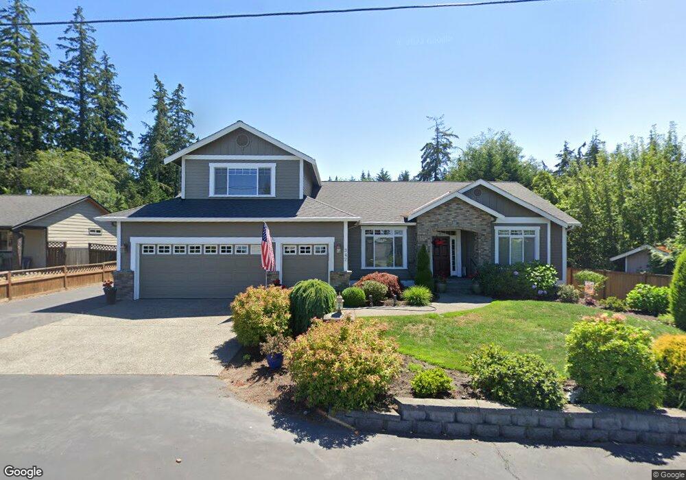
342 MacBrae Dr Camano Island, WA 98282
Estimated Value: $712,588 - $802,000
3
Beds
2
Baths
2,047
Sq Ft
$378/Sq Ft
Est. Value
About This Home
This home is located at 342 MacBrae Dr, Camano Island, WA 98282 and is currently estimated at $774,647, approximately $378 per square foot. 342 MacBrae Dr is a home located in Island County with nearby schools including Utsalady Elementary School, Port Susan Middle School, and Stanwood High School.
Ownership History
Date
Name
Owned For
Owner Type
Purchase Details
Closed on
Aug 21, 2020
Sold by
Maxwell Patrick B and Maxwell Julia A
Bought by
Maxwell Patrick B and Maxwell Julia A
Current Estimated Value
Home Financials for this Owner
Home Financials are based on the most recent Mortgage that was taken out on this home.
Original Mortgage
$212,053
Outstanding Balance
$186,499
Interest Rate
2.9%
Mortgage Type
VA
Estimated Equity
$588,148
Purchase Details
Closed on
Oct 4, 2012
Sold by
Maxwell Patrick B and Maxwell Julia A
Bought by
Maxwell Patrick B and Maxwell Julia A
Purchase Details
Closed on
Dec 6, 2011
Sold by
Clifford George L and Clifford Lurlyn
Bought by
Maxwell Patrick B and Maxwell Julia A
Home Financials for this Owner
Home Financials are based on the most recent Mortgage that was taken out on this home.
Original Mortgage
$250,000
Interest Rate
4.06%
Mortgage Type
VA
Purchase Details
Closed on
Jun 20, 2005
Sold by
Property Management Llc
Bought by
Clifford George L and Clifford Lurlyn
Purchase Details
Closed on
Jul 22, 2004
Sold by
North Puget Construction Inc
Bought by
Property Management Llc
Home Financials for this Owner
Home Financials are based on the most recent Mortgage that was taken out on this home.
Original Mortgage
$256,000
Interest Rate
6.29%
Mortgage Type
Construction
Create a Home Valuation Report for This Property
The Home Valuation Report is an in-depth analysis detailing your home's value as well as a comparison with similar homes in the area
Home Values in the Area
Average Home Value in this Area
Purchase History
| Date | Buyer | Sale Price | Title Company |
|---|---|---|---|
| Maxwell Patrick B | -- | None Available | |
| Maxwell Patrick B | -- | None Available | |
| Maxwell Patrick B | -- | None Available | |
| Maxwell Patrick B | $310,000 | Land Title Escrow Island Co | |
| Clifford George L | $384,000 | -- | |
| Property Management Llc | $90,000 | -- |
Source: Public Records
Mortgage History
| Date | Status | Borrower | Loan Amount |
|---|---|---|---|
| Open | Maxwell Patrick B | $212,053 | |
| Closed | Maxwell Patrick B | $250,000 | |
| Previous Owner | Property Management Llc | $256,000 |
Source: Public Records
Tax History Compared to Growth
Tax History
| Year | Tax Paid | Tax Assessment Tax Assessment Total Assessment is a certain percentage of the fair market value that is determined by local assessors to be the total taxable value of land and additions on the property. | Land | Improvement |
|---|---|---|---|---|
| 2024 | $5,522 | $706,939 | $250,000 | $456,939 |
| 2023 | $5,522 | $712,115 | $250,000 | $462,115 |
| 2022 | $4,957 | $631,967 | $210,000 | $421,967 |
| 2021 | $4,725 | $528,876 | $165,000 | $363,876 |
| 2020 | $4,310 | $488,012 | $135,000 | $353,012 |
| 2019 | $4,016 | $438,660 | $175,000 | $263,660 |
| 2018 | $3,875 | $409,383 | $145,000 | $264,383 |
| 2017 | $3,380 | $365,826 | $100,000 | $265,826 |
| 2016 | $3,036 | $353,716 | $85,000 | $268,716 |
| 2015 | -- | $304,589 | $65,000 | $239,589 |
| 2013 | -- | $299,795 | $55,000 | $244,795 |
Source: Public Records
Map
Nearby Homes
- 0 E Shumway Rd
- 230 Heather Dr
- 335 Heather Dr
- 269 E Lochwood Dr
- 355 Selkirk Dr
- 251 Goodrich Rd
- 302 Melrose Dr
- 362 N Sunrise Blvd
- 245 David St
- 244 David St
- 474 Stirling Dr
- 105 N Sunrise Blvd
- 563 Waynes Ridge Cir
- 0 Dodge Rd Unit NWM2434437
- 0 Dodge Rd Unit NWM2434435
- 230 Rocky Mountain High Rd
- 289 E Driftwood Shores Rd
- 446 Lehman Dr
- 441 Windsun Way
- 169 Driftwood Shores Rd