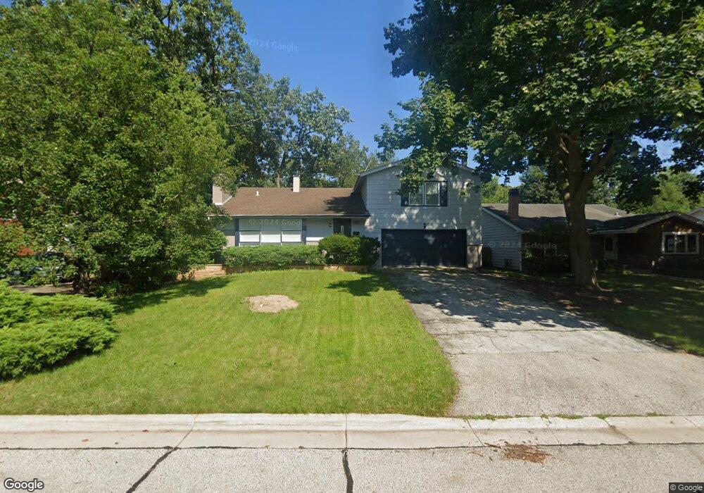
342 N Butterfield Rd Libertyville, IL 60048
Estimated Value: $517,000 - $630,000
--
Bed
3
Baths
1,352
Sq Ft
$419/Sq Ft
Est. Value
About This Home
This home is located at 342 N Butterfield Rd, Libertyville, IL 60048 and is currently estimated at $566,421, approximately $418 per square foot. 342 N Butterfield Rd is a home located in Lake County with nearby schools including Butterfield School, Highland Middle School, and Libertyville High School.
Ownership History
Date
Name
Owned For
Owner Type
Purchase Details
Closed on
Feb 28, 2023
Sold by
Trust Number L017-144
Bought by
Bednarski David M
Current Estimated Value
Home Financials for this Owner
Home Financials are based on the most recent Mortgage that was taken out on this home.
Original Mortgage
$464,400
Outstanding Balance
$449,450
Interest Rate
5.99%
Mortgage Type
New Conventional
Estimated Equity
$116,971
Purchase Details
Closed on
Mar 16, 2015
Sold by
Swanson Gary T
Bought by
Swanson Gary T and Gary T Swanson Revocable Trust
Create a Home Valuation Report for This Property
The Home Valuation Report is an in-depth analysis detailing your home's value as well as a comparison with similar homes in the area
Home Values in the Area
Average Home Value in this Area
Purchase History
| Date | Buyer | Sale Price | Title Company |
|---|---|---|---|
| Bednarski David M | $516,000 | Chicago Title | |
| Swanson Gary T | -- | None Available |
Source: Public Records
Mortgage History
| Date | Status | Borrower | Loan Amount |
|---|---|---|---|
| Open | Bednarski David M | $464,400 |
Source: Public Records
Tax History Compared to Growth
Tax History
| Year | Tax Paid | Tax Assessment Tax Assessment Total Assessment is a certain percentage of the fair market value that is determined by local assessors to be the total taxable value of land and additions on the property. | Land | Improvement |
|---|---|---|---|---|
| 2024 | $11,932 | $160,635 | $42,045 | $118,590 |
| 2023 | $7,029 | $148,160 | $38,780 | $109,380 |
| 2022 | $7,029 | $98,885 | $37,273 | $61,612 |
| 2021 | $5,073 | $96,757 | $36,471 | $60,286 |
| 2020 | $4,969 | $95,130 | $35,858 | $59,272 |
| 2019 | $4,827 | $94,225 | $35,517 | $58,708 |
| 2018 | $4,811 | $94,271 | $41,726 | $52,545 |
| 2017 | $4,824 | $91,295 | $40,409 | $50,886 |
| 2016 | $4,930 | $86,560 | $38,313 | $48,247 |
| 2015 | $5,242 | $80,905 | $35,810 | $45,095 |
| 2014 | $5,357 | $75,417 | $31,230 | $44,187 |
| 2012 | $5,108 | $76,071 | $31,501 | $44,570 |
Source: Public Records
Map
Nearby Homes
- 223 Kenloch Ave
- 1330 W Park Ave
- 1137 Pine Tree Ln
- 20924 & 20902 W Park Ave
- 533 Drake St
- 551 W Park Ave Unit E
- 423 Ames St
- 832 Interlaken Ln
- 0 Ames St
- 420 W Cook Ave
- 505 Lange Ct
- 308 Mckinley Ave
- 212 Elm Ct
- 694 Parkside Ct
- 1754 Glenmore Rd
- 619 Parkside Ct
- 662 Parkside Ct
- 624 Parkside Ct
- 616 Parkside Ct
- 777 Garfield Ave Unit A
- 342 Butterfield Ln
- 334 N Butterfield Rd
- 400 Butterfield Ln
- 328 N Butterfield Rd
- 175 Blueberry Rd
- 181 Blueberry Rd
- 324 N Butterfield Rd
- 169 Blueberry Rd
- 405 Butterfield Ln
- 343 Butterfield Ln
- 339 S Butterfield Rd
- 339 Butterfield Ln
- 405 N Butterfield Rd
- 333 S Butterfield Rd
- 163 Blueberry Rd
- 187 Blueberry Rd
- 316 N Butterfield Rd
- 402 N Butterfield Rd
- 178 Blueberry Rd
- 157 Blueberry Rd