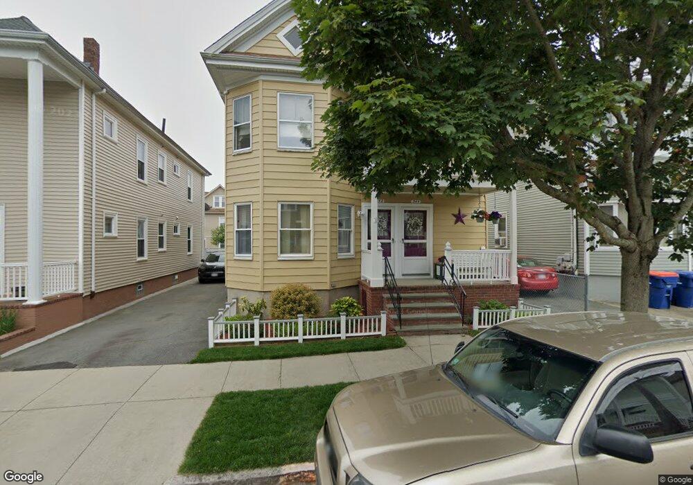
342 Shaw St Unit 344 New Bedford, MA 02745
Acushnet Station NeighborhoodEstimated Value: $452,101 - $622,000
5
Beds
2
Baths
2,454
Sq Ft
$216/Sq Ft
Est. Value
About This Home
This home is located at 342 Shaw St Unit 344, New Bedford, MA 02745 and is currently estimated at $530,275, approximately $216 per square foot. 342 Shaw St Unit 344 is a home located in Bristol County with nearby schools including Abraham Lincoln Elementary School, Normandin Middle School, and New Bedford High School.
Ownership History
Date
Name
Owned For
Owner Type
Purchase Details
Closed on
Apr 4, 2012
Sold by
Flood Janice V and Flood Richard J
Bought by
Flood Janice V and Flood Richard J
Current Estimated Value
Purchase Details
Closed on
Jan 31, 1994
Sold by
Bohn Norma P
Bought by
Flood Richard and Flood Janice V
Create a Home Valuation Report for This Property
The Home Valuation Report is an in-depth analysis detailing your home's value as well as a comparison with similar homes in the area
Home Values in the Area
Average Home Value in this Area
Purchase History
| Date | Buyer | Sale Price | Title Company |
|---|---|---|---|
| Flood Janice V | -- | -- | |
| Flood Janice V | -- | -- | |
| Flood Richard | $58,000 | -- | |
| Flood Richard | $58,000 | -- |
Source: Public Records
Mortgage History
| Date | Status | Borrower | Loan Amount |
|---|---|---|---|
| Previous Owner | Flood Richard | $152,000 | |
| Previous Owner | Flood Richard | $130,000 | |
| Previous Owner | Flood Richard | $19,000 |
Source: Public Records
Tax History Compared to Growth
Tax History
| Year | Tax Paid | Tax Assessment Tax Assessment Total Assessment is a certain percentage of the fair market value that is determined by local assessors to be the total taxable value of land and additions on the property. | Land | Improvement |
|---|---|---|---|---|
| 2025 | $4,847 | $428,600 | $103,500 | $325,100 |
| 2024 | $4,814 | $401,200 | $100,200 | $301,000 |
| 2023 | $4,636 | $324,400 | $84,200 | $240,200 |
| 2022 | $4,191 | $269,700 | $80,200 | $189,500 |
| 2021 | $4,205 | $269,700 | $80,200 | $189,500 |
| 2020 | $4,063 | $251,400 | $81,800 | $169,600 |
| 2019 | $3,971 | $241,100 | $81,800 | $159,300 |
| 2018 | $3,725 | $224,000 | $81,800 | $142,200 |
| 2017 | $3,258 | $195,200 | $75,200 | $120,000 |
| 2016 | $3,077 | $186,600 | $71,800 | $114,800 |
| 2015 | $2,874 | $182,700 | $71,800 | $110,900 |
| 2014 | $2,753 | $181,600 | $70,100 | $111,500 |
Source: Public Records
Map
Nearby Homes
- 208 Princeton St
- 162 Princeton St
- 250-252 Shaw St
- 228 Eugenia St
- 135-137 Query St
- 18 Edison St
- 203-205 Tinkham St
- 42 Princeton St
- 1840 1846 Acushnet Ave
- 82 Query St
- 113 Eugenia St
- 125 +135 Tinkham St
- 128 Nash Rd
- 42 Query St
- 219 Hathaway St
- 424 Church St
- 178 Lafayette St
- 301 Davis St
- 11 Moynan St
- 447 Wood St
- 346-348 Shaw St
- 338 Shaw St Unit 340
- 346 Shaw St Unit 348
- 334 Shaw St Unit 336
- 350 Shaw St Unit 352
- 265-267 Central Ave
- 265 Central Ave Unit 267
- 259 Central Ave Unit 261
- 269 Central Ave Unit 271
- 259-261 Central Ave
- 330 Shaw St Unit 332
- 354 Shaw St Unit 356
- 330-332 Shaw St
- 261 Central Ave
- 255 Central Ave Unit 257
- 347 Shaw St
- 351 Shaw St
- 335 Shaw St
- 251 Central Ave Unit 253
- 326 Shaw St