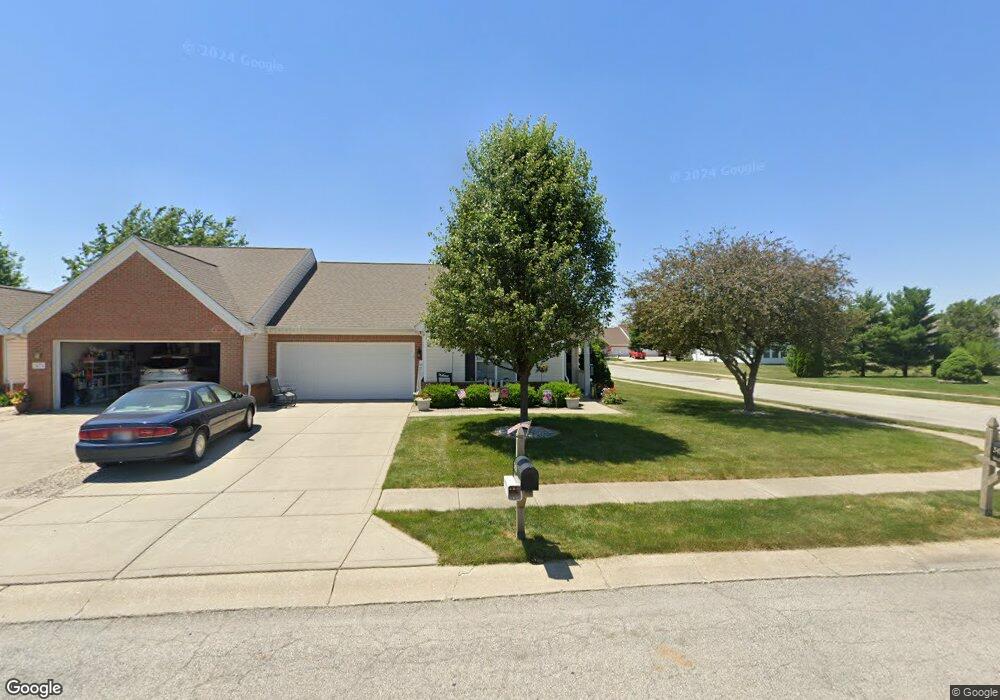
3436 Weathered Rock Cir Kokomo, IN 46902
Estimated Value: $213,375 - $235,000
2
Beds
2
Baths
1,405
Sq Ft
$161/Sq Ft
Est. Value
About This Home
This home is located at 3436 Weathered Rock Cir, Kokomo, IN 46902 and is currently estimated at $226,594, approximately $161 per square foot. 3436 Weathered Rock Cir is a home located in Howard County with nearby schools including Boulevard Elementary School, Maple Crest Middle School, and Kokomo High School.
Ownership History
Date
Name
Owned For
Owner Type
Purchase Details
Closed on
May 31, 2022
Sold by
Dorothy Oneill Cecilia
Bought by
Cook Steven E and Cook Constance J
Current Estimated Value
Home Financials for this Owner
Home Financials are based on the most recent Mortgage that was taken out on this home.
Original Mortgage
$50,000
Outstanding Balance
$44,860
Interest Rate
5%
Mortgage Type
New Conventional
Estimated Equity
$181,734
Purchase Details
Closed on
May 30, 2022
Sold by
Oneill Cecilia Dorothy and Oneill-Schossler Maureen A
Bought by
Cook Steven E and Cook Constance J
Home Financials for this Owner
Home Financials are based on the most recent Mortgage that was taken out on this home.
Original Mortgage
$50,000
Outstanding Balance
$44,860
Interest Rate
5%
Mortgage Type
New Conventional
Estimated Equity
$181,734
Purchase Details
Closed on
Mar 16, 2021
Sold by
Dorothy Oneill Cecilia
Bought by
Oneill-Schossler Maureen A and Oneill Monica L
Create a Home Valuation Report for This Property
The Home Valuation Report is an in-depth analysis detailing your home's value as well as a comparison with similar homes in the area
Home Values in the Area
Average Home Value in this Area
Purchase History
| Date | Buyer | Sale Price | Title Company |
|---|---|---|---|
| Cook Steven E | $181,000 | Cord C Michael | |
| Cook Steven E | -- | None Listed On Document | |
| Oneill-Schossler Maureen A | -- | Cord C Michael |
Source: Public Records
Mortgage History
| Date | Status | Borrower | Loan Amount |
|---|---|---|---|
| Open | Cook Steven E | $50,000 | |
| Closed | Cook Steven E | $50,000 |
Source: Public Records
Tax History Compared to Growth
Tax History
| Year | Tax Paid | Tax Assessment Tax Assessment Total Assessment is a certain percentage of the fair market value that is determined by local assessors to be the total taxable value of land and additions on the property. | Land | Improvement |
|---|---|---|---|---|
| 2024 | $1,679 | $174,300 | $27,000 | $147,300 |
| 2023 | $1,679 | $167,900 | $23,300 | $144,600 |
| 2022 | $281 | $165,300 | $23,300 | $142,000 |
| 2021 | $275 | $145,200 | $23,300 | $121,900 |
| 2020 | $270 | $136,500 | $23,300 | $113,200 |
| 2019 | $264 | $126,400 | $22,000 | $104,400 |
| 2018 | $299 | $124,800 | $22,000 | $102,800 |
| 2017 | $294 | $124,000 | $22,000 | $102,000 |
| 2016 | $289 | $119,300 | $22,000 | $97,300 |
| 2014 | $239 | $106,700 | $20,700 | $86,000 |
| 2013 | $235 | $105,900 | $20,700 | $85,200 |
Source: Public Records
Map
Nearby Homes
- 2786 Bridgestone Cir
- 2837 Bridgestone Cir
- 2856 Bridgestone Cir
- 2902 Bridgestone Cir
- 2205 Carmelita Blvd
- 1712 Gordon Dr
- 111 Chateau Ct
- 2505 Elaine Ct
- 1914 Versailles Dr
- 2109 Elva Dr
- 1206 Doud Dr
- 0 S Dixon Rd Unit 202540753
- 0 S Dixon Rd Unit MBR22067220
- 2401 Greentree Ln
- 1420 S Dixon Rd
- 36 S 300 W
- 1305 Red Bird Ct
- 2913 Mayor Dr
- 2715 Whitehouse Dr
- 750 Riverview Dr
- 3434 Weathered Rock Cir
- 2806 Bridgestone Cir
- 3430 Weathered Rock Cir
- 2808 Bridgestone Cir
- 3440 Weathered Rock Cir
- 3431 Weathered Rock Cir
- 2812 Bridgestone Cir
- 3437 Weathered Rock Cir
- 3437 Weathered Rock Cir Unit 1
- 3429 Weathered Rock Cir
- 2798 Bridgestone Cir
- 3439 Weathered Rock Cir
- 3428 Weathered Rock Cir
- 2814 Bridgestone Cir
- 2796 Bridgestone Cir
- 3424 Weathered Rock Cir
- 3442 Weathered Rock Cir
- 3417 Weathered Rock Cir
- 3445 Weathered Rock Cir
- 2792 Bridgestone Cir