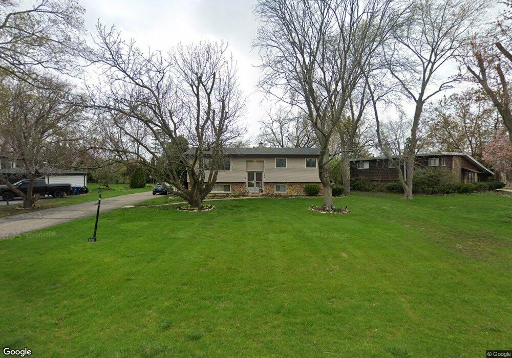
344 67th St Willowbrook, IL 60527
Estimated Value: $370,000 - $539,000
Studio
2
Baths
1,210
Sq Ft
$379/Sq Ft
Est. Value
About This Home
This home is located at 344 67th St, Willowbrook, IL 60527 and is currently estimated at $458,615, approximately $379 per square foot. 344 67th St is a home located in DuPage County with nearby schools including Holmes Elementary School, Maercker Elementary School, and Westview Hills Middle School.
Ownership History
Date
Name
Owned For
Owner Type
Purchase Details
Closed on
May 15, 2022
Sold by
Rafael Anthony Parra Revocable Living Tr
Bought by
Parra Rafael A and Parra Nitsa
Current Estimated Value
Purchase Details
Closed on
Jun 26, 2019
Sold by
Parra Rafael Anthony and Parra Nitsa
Bought by
Rlt Parra Rafael Anthony and Rafael Anthony Parra Rlt
Purchase Details
Closed on
Apr 20, 1994
Sold by
Hinsbrook Bank & Trust Of Willowbrook
Bought by
Parra Rafael A and Parra Nitsa
Home Financials for this Owner
Home Financials are based on the most recent Mortgage that was taken out on this home.
Original Mortgage
$115,000
Interest Rate
7.84%
Create a Home Valuation Report for This Property
The Home Valuation Report is an in-depth analysis detailing your home's value as well as a comparison with similar homes in the area
Home Values in the Area
Average Home Value in this Area
Purchase History
| Date | Buyer | Sale Price | Title Company |
|---|---|---|---|
| Parra Rafael A | -- | Lenius Joseph F | |
| Rlt Parra Rafael Anthony | -- | Attorney | |
| Parra Rafael A | $169,000 | Attorneys Title Guaranty Fun |
Source: Public Records
Mortgage History
| Date | Status | Borrower | Loan Amount |
|---|---|---|---|
| Previous Owner | Parra Rafael A | $115,000 |
Source: Public Records
Tax History
| Year | Tax Paid | Tax Assessment Tax Assessment Total Assessment is a certain percentage of the fair market value that is determined by local assessors to be the total taxable value of land and additions on the property. | Land | Improvement |
|---|---|---|---|---|
| 2024 | $7,389 | $130,547 | $88,786 | $41,761 |
| 2023 | $7,073 | $120,010 | $81,620 | $38,390 |
| 2022 | $7,386 | $115,620 | $79,950 | $35,670 |
| 2021 | $7,122 | $114,300 | $79,040 | $35,260 |
| 2020 | $7,009 | $112,030 | $77,470 | $34,560 |
| 2019 | $6,775 | $107,490 | $74,330 | $33,160 |
| 2018 | $6,783 | $108,370 | $73,960 | $34,410 |
| 2017 | $6,538 | $104,280 | $71,170 | $33,110 |
| 2016 | $6,376 | $99,520 | $67,920 | $31,600 |
| 2015 | $6,295 | $93,630 | $63,900 | $29,730 |
| 2014 | $6,634 | $98,270 | $62,130 | $36,140 |
| 2013 | $6,445 | $97,810 | $61,840 | $35,970 |
Source: Public Records
Map
Nearby Homes
- 6136 Bentley Ave
- 6648 Weather Hill Dr
- 318 Arabian Cir
- 6503 Clarendon Hills Rd
- 401 69th St
- 601 Lake Hinsdale Dr Unit 101
- 601 Lake Hinsdale Dr Unit 112
- 301 Lake Hinsdale Dr Unit 108
- 301 Lake Hinsdale Dr Unit 404
- 6925 Clarendon Hills Rd
- 701 Lake Hinsdale Dr Unit 306
- 19 Portwine Rd
- 335 63rd St
- 6340 Americana Dr Unit 904
- 6340 Americana Dr Unit 701
- 101 Lake Hinsdale Dr Unit 205
- 77 Lake Hinsdale Dr Unit 207
- 200 Brookside Ln Unit A
- 230 Windsor Ln Unit A
- 1224 Ridge Rd
Your Personal Tour Guide
Ask me questions while you tour the home.