Estimated payment $8,672/month
Highlights
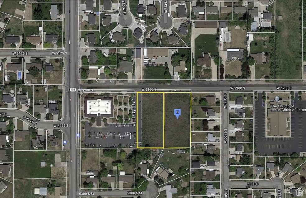
- 1.94 Acre Lot
- Views
- No Heating
- No HOA
About This Lot
Recently the city zoned it mixed use as well as been approved for muilti-family units by the city. Reach out to find out what this property has to offer as well as what has been done to develope on it. BOTH 3423 & 3443 W (09-577-0003 & 09-577-0002) totaling 1.94 acres.

Property Details
Property Type
- Land
Est. Annual Taxes
- $3,231
Lot Details
- 1.94 Acre Lot
- Property is zoned Commercial, MIXED
Schools
- Midland Elementary School
- Roy Middle School
- Roy High School
Additional Features
- Property Views
Community Details
- No Home Owners Association
- Ogden Clinic Subdivi Subdivision
Listing and Financial Details
- Assessor Parcel Number 09-577-0002
Map
Home Values in the Area
Average Home Value in this Area
Tax History
| Year | Tax Paid | Tax Assessment Tax Assessment Total Assessment is a certain percentage of the fair market value that is determined by local assessors to be the total taxable value of land and additions on the property. | Land | Improvement |
|---|---|---|---|---|
| 2025 | $3,291 | $319,258 | $319,258 | $0 |
| 2024 | $3,236 | $315,250 | $315,250 | $0 |
| 2023 | $3,231 | $315,250 | $315,250 | $0 |
| 2022 | $2,929 | $291,000 | $291,000 | $0 |
| 2021 | $2,678 | $242,500 | $242,500 | $0 |
| 2020 | $2,224 | $184,300 | $184,300 | $0 |
| 2019 | $2,293 | $179,450 | $179,450 | $0 |
| 2018 | $2,426 | $179,450 | $179,450 | $0 |
| 2017 | $2,577 | $179,450 | $179,450 | $0 |
| 2016 | $2,496 | $169,750 | $169,750 | $0 |
| 2015 | $2,399 | $169,750 | $169,750 | $0 |
| 2014 | $2,444 | $169,750 | $169,750 | $0 |
Property History
| Date | Event | Price | List to Sale | Price per Sq Ft |
|---|---|---|---|---|
| 01/02/2025 01/02/25 | For Sale | $1,599,000 | 0.0% | -- |
| 01/01/2025 01/01/25 | Off Market | -- | -- | -- |
| 05/24/2024 05/24/24 | For Sale | $1,599,000 | -- | -- |
Purchase History
| Date | Type | Sale Price | Title Company |
|---|---|---|---|
| Warranty Deed | -- | Sutherland Title Company | |
| Warranty Deed | -- | Sutherland Title Company | |
| Warranty Deed | -- | Mountain View Title |
Mortgage History
| Date | Status | Loan Amount | Loan Type |
|---|---|---|---|
| Open | $330,000 | New Conventional | |
| Previous Owner | $236,000 | Commercial |
Source: UtahRealEstate.com
MLS Number: 2000783
APN: 09-577-0002
Disclaimer: Certain information contained herein is derived from information provided by parties other than Homes.com. All information provided is deemed reliable, but is not guaranteed to be accurate and should be independently verified.
![]() IDX information is provided exclusively for consumers’ personal, non-commercial use, that it may not be used for any purpose other than to identify prospective properties consumers may be interested in purchasing, and that the data is deemed reliable but is not guaranteed accurate by the MLS. Licensor is only providing the MLS Content and not other sources of data provided in the Product.
IDX information is provided exclusively for consumers’ personal, non-commercial use, that it may not be used for any purpose other than to identify prospective properties consumers may be interested in purchasing, and that the data is deemed reliable but is not guaranteed accurate by the MLS. Licensor is only providing the MLS Content and not other sources of data provided in the Product.
Based on information from the Wasatch Front Regional Multiple Listing Service, Inc.. All data, including all measurements and calculations of area, is obtained from various sources and has not been, and will not be, verified by broker or the MLS. All information should be independently reviewed and verified for accuracy. Properties may or may not be listed by the office/agent presenting the information.
- 3607 W 5400 S
- 3509 W 4835 S Unit 26
- 5321 S 3100 W
- 3523 W 4835 S Unit 28
- 3512 W 4835 S Unit 24
- 3524 W 4835 S Unit 22
- 3766 W 5300 S
- 5432 S 3150 W
- 5578 S 3450 W
- 5538 S 3150 W
- 3176 W 5625 S
- 3166 W 5625 S
- 5009 S 2925 W
- 3809 W 5625 S
- 3832 W 5625 S
- 5173 S 2825 W
- 3632 W 4650 S
- 4918 S 2925 W
- 5063 S 2825 W
- 5003 S 2825 W
- 3652 W 4625 S
- 5447 Midland Dr
- 4151 W 5400 S
- 5397 S 4200 W
- 4045 W 4650 S
- 4056 W 4600 S
- 4235 W 5475 S
- 3024 W 4450 S
- 2672 W 5750 S Unit 2672
- 2575 W 4800 S
- 2619 W 4650 S
- 4419 S 2750 W
- 4389 S Locomotive Dr
- 3330 W 4000 S
- 3329 W 3745 S
- 2285 W 5950 S Unit Basement
- 3339 W 3715 S Unit 4077
- 2359 W 2075 N
- 2602 W 4050 S
- 2617 W 2100 N