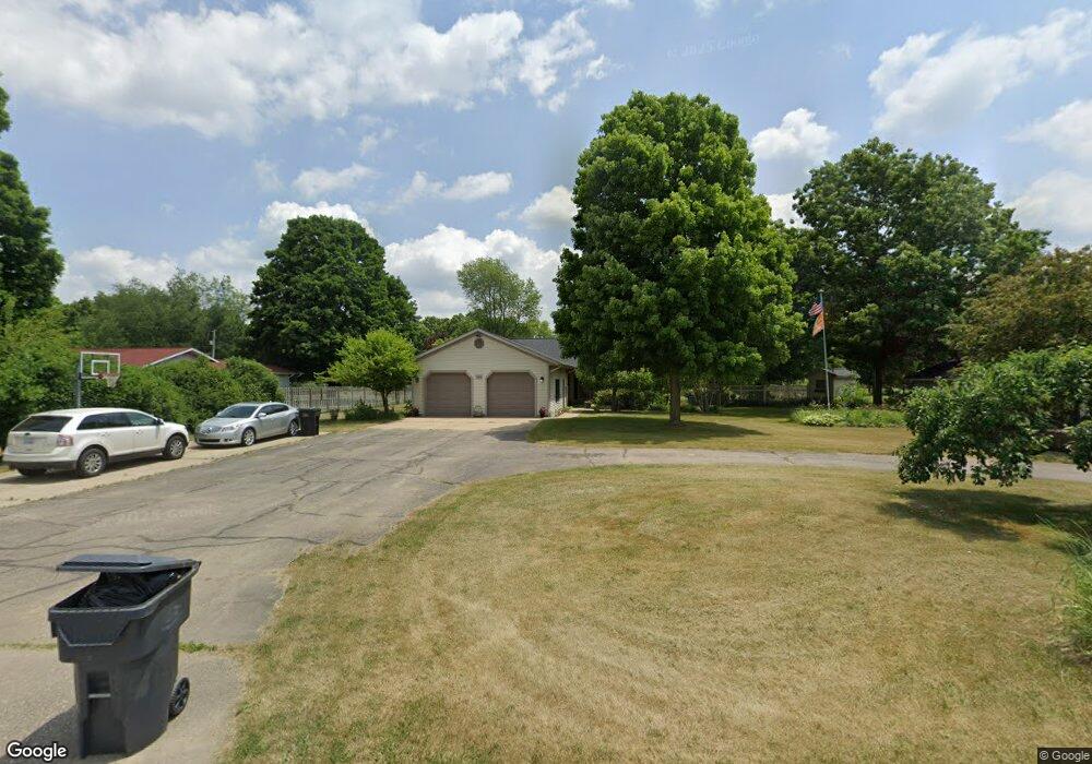
345 19th St Otsego, MI 49078
Estimated Value: $357,399 - $446,000
--
Bed
2
Baths
2,200
Sq Ft
$178/Sq Ft
Est. Value
About This Home
This home is located at 345 19th St, Otsego, MI 49078 and is currently estimated at $390,600, approximately $177 per square foot. 345 19th St is a home located in Allegan County with nearby schools including Otsego High School, Otsego Christian Academy, and St. Margaret School.
Ownership History
Date
Name
Owned For
Owner Type
Purchase Details
Closed on
Sep 15, 2020
Sold by
Atkins Cassandra Jane
Bought by
Devine Alan J and Devine Savannah L
Current Estimated Value
Home Financials for this Owner
Home Financials are based on the most recent Mortgage that was taken out on this home.
Original Mortgage
$188,000
Outstanding Balance
$166,528
Interest Rate
2.8%
Mortgage Type
New Conventional
Estimated Equity
$224,072
Purchase Details
Closed on
Jul 16, 2008
Sold by
Atkins Gary Lee
Bought by
Atkins Cassandra Jane
Purchase Details
Closed on
Oct 5, 1998
Sold by
Sunnock Gerald E and Sunnock Margaret S
Bought by
Atkins Gary and Atkins Cassandra
Purchase Details
Closed on
Aug 1, 1991
Sold by
Brewer Paul E and Brewer Melody
Bought by
"Sunnock
Purchase Details
Closed on
Jun 1, 1991
Sold by
Brewer Paul E and Brewer Melody
Bought by
"Arguijo
Create a Home Valuation Report for This Property
The Home Valuation Report is an in-depth analysis detailing your home's value as well as a comparison with similar homes in the area
Home Values in the Area
Average Home Value in this Area
Purchase History
| Date | Buyer | Sale Price | Title Company |
|---|---|---|---|
| Devine Alan J | $260,000 | None Available | |
| Atkins Cassandra Jane | -- | None Available | |
| Atkins Gary | $179,900 | -- | |
| "Sunnock | $8,000 | -- | |
| "Arguijo | -- | -- |
Source: Public Records
Mortgage History
| Date | Status | Borrower | Loan Amount |
|---|---|---|---|
| Open | Devine Alan J | $188,000 |
Source: Public Records
Tax History Compared to Growth
Tax History
| Year | Tax Paid | Tax Assessment Tax Assessment Total Assessment is a certain percentage of the fair market value that is determined by local assessors to be the total taxable value of land and additions on the property. | Land | Improvement |
|---|---|---|---|---|
| 2025 | $4,753 | $184,400 | $10,200 | $174,200 |
| 2024 | $3,905 | $161,700 | $10,200 | $151,500 |
| 2023 | $3,976 | $137,300 | $10,000 | $127,300 |
| 2022 | $3,905 | $124,500 | $9,500 | $115,000 |
| 2021 | $3,698 | $118,800 | $8,800 | $110,000 |
| 2020 | $2,776 | $107,100 | $7,600 | $99,500 |
| 2019 | $2,689 | $101,400 | $6,300 | $95,100 |
| 2018 | $2,631 | $93,700 | $6,500 | $87,200 |
| 2017 | $0 | $93,200 | $8,600 | $84,600 |
| 2016 | $0 | $87,700 | $7,100 | $80,600 |
| 2015 | -- | $87,700 | $7,100 | $80,600 |
| 2014 | $4,721 | $81,200 | $5,600 | $75,600 |
| 2013 | $4,721 | $86,800 | $6,100 | $80,700 |
Source: Public Records
Map
Nearby Homes
- 0 Briarwood St Unit 25002251
- 602 Lincoln Rd
- 552 19th St
- 1651 Aspen Trail
- 1643 Aspen Trail
- 1647 Aspen Trail
- 1635 Aspen Trail
- 589 Lincoln Rd
- Elements 1870 Plan at Southpointe Trails
- Integrity 1605 Plan at Southpointe Trails
- Elements 2070 Plan at Southpointe Trails
- Integrity 2000 Plan at Southpointe Trails
- Elements 1680 Plan at Southpointe Trails
- integrity 2280 Plan at Southpointe Trails
- Integrity 1910 Plan at Southpointe Trails
- integrity 1800 Plan at Southpointe Trails
- Integrity 2061 V8.1a Plan at Southpointe Trails
- Elements 2390 Plan at Southpointe Trails
- Integrity 2190 Plan at Southpointe Trails
- Elements 2100 Plan at Southpointe Trails