345 2nd Ave Unit 11 Long Branch, NJ 07740
Estimated payment $11,699/month
Highlights
- Ocean View
- Heated In Ground Pool
- Wood Flooring
- New Construction
- Property is near an ocean
- Terrace
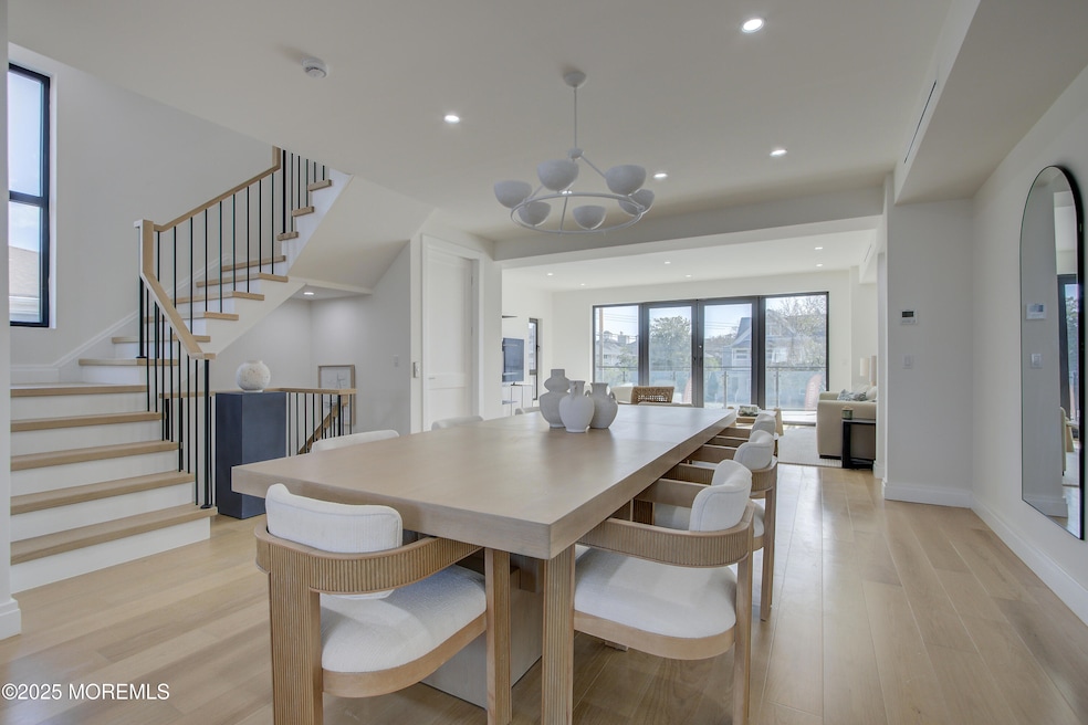
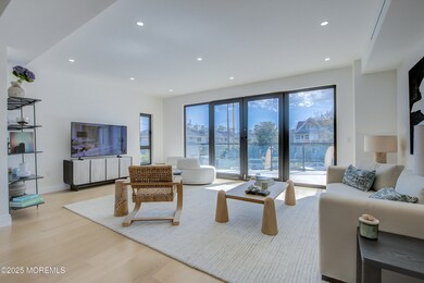
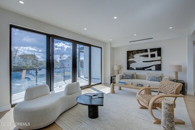
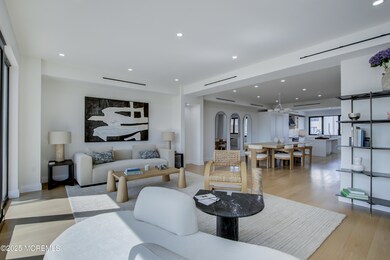
About This Home
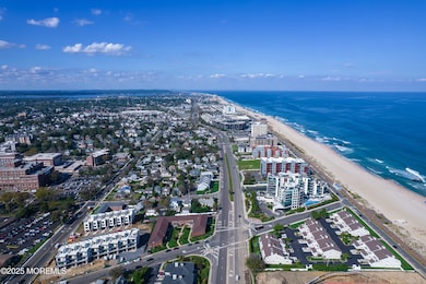
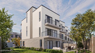
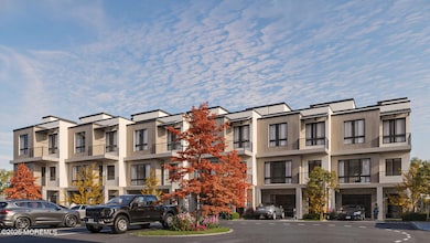
New Construction! Experience Unparalleled Luxury Living at The Seashore in Long Branch! Ride your private in-unit elevator up 4 levels to your expansive 800+sqft rooftop terrace & savor sweeping ocean views. Just minutes from the beach & Pier Village, this limited collection of 14 luxury townhomes offers over 3,000 sqft of designer living space with 3 bedrooms + den, 3.5 baths, multiple balconies, a private patio & heated garage with EV charger. A modern masterpiece, each home features custom European windows and doors, open-concept living, and a chef's kitchen with premium smart appliances: Nostalgie by ILVE stove & SAVALO refrigerator and dishwasher. After a day at the beach, relax in the exclusive heated resort-style pool or explore the vibrant dining, shopping, and nightlife of Pier Village, Red Bank, Asbury Park, and Sea Bright with NYC just a ferry ride away. Located minutes from the future home of Netflix, this is coastal luxury at its finest!
Open House Schedule
-
Sunday, November 16, 202512:00 to 3:00 pm11/16/2025 12:00:00 PM +00:0011/16/2025 3:00:00 PM +00:00Add to Calendar
Townhouse Details
Home Type
- Townhome
Est. Annual Taxes
- $13,982
Year Built
- Built in 2025 | New Construction
Lot Details
- Landscaped
- Sprinkler System
HOA Fees
- $520 Monthly HOA Fees
Parking
- 1 Car Direct Access Garage
- Oversized Parking
- Garage Door Opener
- Driveway
Home Design
- Flat Roof Shape
Interior Spaces
- 3,000 Sq Ft Home
- 4-Story Property
- Elevator
- Crown Molding
- Ceiling height of 9 feet on the upper level
- Recessed Lighting
- Sliding Doors
- Wood Flooring
- Ocean Views
Kitchen
- Breakfast Area or Nook
- Stove
- Range Hood
- Freezer
- Dishwasher
- Kitchen Island
Bedrooms and Bathrooms
- 3 Bedrooms
- Walk-In Closet
- Primary Bathroom is a Full Bathroom
Pool
- Heated In Ground Pool
- Outdoor Pool
Outdoor Features
- Property is near an ocean
- Balcony
- Patio
- Terrace
- Exterior Lighting
Schools
- Long Branch Middle School
Utilities
- Forced Air Zoned Heating and Cooling System
- Electric Water Heater
Listing and Financial Details
- Assessor Parcel Number 27-00212-0000-00011
Community Details
Overview
- Front Yard Maintenance
- Association fees include trash, common area, lawn maintenance, mgmt fees, pool, snow removal
- Seashore@Lb Subdivision, 3Br+Den Floorplan
- Electric Vehicle Charging Station
Amenities
- Common Area
Recreation
- Community Pool
- Snow Removal
Pet Policy
- Dogs and Cats Allowed
Map
Home Values in the Area
Average Home Value in this Area
Tax History
| Year | Tax Paid | Tax Assessment Tax Assessment Total Assessment is a certain percentage of the fair market value that is determined by local assessors to be the total taxable value of land and additions on the property. | Land | Improvement |
|---|---|---|---|---|
| 2025 | $13,982 | $2,066,000 | $2,066,000 | -- |
| 2024 | $13,982 | $930,300 | $930,300 | $0 |
| 2023 | $13,982 | $900,300 | $900,300 | $0 |
| 2022 | $22,113 | $1,153,400 | $420,300 | $733,100 |
| 2021 | $22,113 | $1,105,100 | $345,300 | $759,800 |
| 2020 | $21,843 | $1,045,100 | $285,300 | $759,800 |
| 2019 | $20,917 | $995,100 | $285,300 | $709,800 |
| 2018 | $21,036 | $995,100 | $285,300 | $709,800 |
| 2017 | $20,305 | $985,200 | $285,300 | $699,900 |
| 2016 | $19,911 | $985,200 | $285,300 | $699,900 |
| 2015 | $21,295 | $956,200 | $393,600 | $562,600 |
| 2014 | $19,942 | $943,800 | $381,200 | $562,600 |
Property History
| Date | Event | Price | List to Sale | Price per Sq Ft |
|---|---|---|---|---|
| 10/06/2025 10/06/25 | For Sale | $1,900,000 | -- | $633 / Sq Ft |
Purchase History
| Date | Type | Sale Price | Title Company |
|---|---|---|---|
| Deed | -- | None Listed On Document | |
| Deed | $1,050,000 | None Listed On Document | |
| Deed | -- | Agent For Old Republic Natio | |
| Deed | -- | None Available |
Mortgage History
| Date | Status | Loan Amount | Loan Type |
|---|---|---|---|
| Previous Owner | $1,400,000 | Commercial |
Source: MOREMLS (Monmouth Ocean Regional REALTORS®)
MLS Number: 22530253
APN: 27-00212-0000-00011
Disclaimer: Certain information contained herein is derived from information provided by parties other than Homes.com. All information provided is deemed reliable, but is not guaranteed to be accurate and should be independently verified.
![]() IDX information is provided exclusively for personal, non-commercial use, and may not be used for any purpose other than to identify prospective properties consumers may be interested in purchasing.
IDX information is provided exclusively for personal, non-commercial use, and may not be used for any purpose other than to identify prospective properties consumers may be interested in purchasing.
Information is deemed reliable but not guaranteed.
- 345 2nd Ave Unit 12
- 345 2nd Ave Unit 14
- 345 2nd Ave Unit 8
- 390 Ocean Ave Unit PENTHOUSE C
- 390 Ocean Ave Unit 2308
- 390 Ocean Ave Unit 2410
- 390 Ocean Ave Unit 2606
- 390 Ocean Ave Unit 2205
- 390 Ocean Ave Unit 2804
- 390 Ocean Ave Unit 2306
- 390 Ocean Ave Unit 2505
- 390 Ocean Ave Unit 2211
- 390 Ocean Ave Unit 2411
- 390 Ocean Ave Unit PENTHOUSE D
- 390 Ocean Ave Unit 2705
- 390 Ocean Ave Unit 2506
- 392 Ocean Ave Unit 1305
- 392 Ocean Ave Unit 1203
- 392 Ocean Ave Unit 1412
- 392 Ocean Ave Unit 1502
- 70 N Bath Ave Unit .1
- 70 N Bath Ave Unit 1
- 52 Dunbar Ave Unit A
- 52 Dunbar Ave Unit B
- 282 Van Pelt Place Unit 2
- 385 Ocean Blvd
- 13 Arthur Ave
- 345 Ocean Blvd Unit 201
- 345 Ocean Blvd Unit 301
- 345 Ocean Blvd Unit 402
- 42 Cottage Place Unit 2
- 345 Ocean Blvd
- 444 Ocean Blvd
- 165 Pavilion Ave Unit 303
- 165 Pavilion Ave Unit 206
- 95 Matilda Terrace
- 130 Morris Ave
- 450 Ocean Blvd Unit 8
- 455 Ocean Blvd Unit 25
- 455 Ocean Blvd Unit 26
