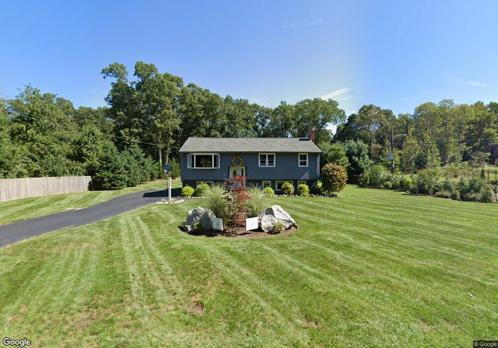
345 Madison St Wrentham, MA 02093
Estimated Value: $595,000 - $644,000
3
Beds
1
Bath
1,656
Sq Ft
$374/Sq Ft
Est. Value
About This Home
This home is located at 345 Madison St, Wrentham, MA 02093 and is currently estimated at $619,108, approximately $373 per square foot. 345 Madison St is a home located in Norfolk County with nearby schools including Delaney Elementary School, Charles E Roderick, and Discovery Daycare Center.
Ownership History
Date
Name
Owned For
Owner Type
Purchase Details
Closed on
Apr 12, 2023
Sold by
Smith Jacqueline S
Bought by
Sherman Ret
Current Estimated Value
Purchase Details
Closed on
Nov 13, 2020
Sold by
Smith Charles A and Smith Jaqueline S
Bought by
Smith Jaqueline S
Purchase Details
Closed on
May 30, 2000
Sold by
Kavanaugh Patricia A
Bought by
Smith Charles A and Smith Jacqueline S
Create a Home Valuation Report for This Property
The Home Valuation Report is an in-depth analysis detailing your home's value as well as a comparison with similar homes in the area
Purchase History
| Date | Buyer | Sale Price | Title Company |
|---|---|---|---|
| Sherman Ret | -- | None Available | |
| Smith Jaqueline S | -- | None Available | |
| Smith Charles A | $215,000 | -- |
Source: Public Records
Mortgage History
| Date | Status | Borrower | Loan Amount |
|---|---|---|---|
| Previous Owner | Smith Charles A | $90,000 | |
| Previous Owner | Smith Charles A | $133,500 | |
| Previous Owner | Smith Charles A | $134,525 |
Source: Public Records
Tax History
| Year | Tax Paid | Tax Assessment Tax Assessment Total Assessment is a certain percentage of the fair market value that is determined by local assessors to be the total taxable value of land and additions on the property. | Land | Improvement |
|---|---|---|---|---|
| 2025 | $6,300 | $543,600 | $315,300 | $228,300 |
| 2024 | $5,944 | $495,300 | $315,300 | $180,000 |
| 2023 | $5,626 | $445,800 | $286,700 | $159,100 |
| 2022 | $5,223 | $382,100 | $246,100 | $136,000 |
| 2021 | $5,062 | $359,800 | $258,600 | $101,200 |
| 2020 | $4,695 | $329,500 | $183,100 | $146,400 |
| 2019 | $4,410 | $312,300 | $175,100 | $137,200 |
| 2018 | $4,154 | $291,700 | $157,800 | $133,900 |
| 2017 | $3,912 | $274,500 | $154,700 | $119,800 |
| 2016 | $4,081 | $285,800 | $166,900 | $118,900 |
| 2015 | $3,749 | $250,300 | $145,900 | $104,400 |
| 2014 | $3,687 | $240,800 | $140,300 | $100,500 |
Source: Public Records
Map
Nearby Homes
- 282 Thurston St
- 483 Thurston St
- 10 Nature View Dr
- 15 Nature View Dr
- 3 Earle Stewart Ln
- 10 Earle Stewart Ln Unit Lot 5
- 2 Earle Stewart Ln
- 12 Earle Stewart Ln
- 135 Creek St Unit 2
- 46 Mirimichi St
- 160 Washington St Unit 22
- 576 Dedham St
- 25 Foxboro Rd
- 126 Washington St
- 130 Washington St
- 124 Washington St
- 158 Washington St
- 16 Treasure Island Rd
- 131 Washington St Unit 42
- 131 Washington St Unit 50
- 335 Madison St
- 336 Madison St
- 354 Madison St
- 359 Madison St
- 15 Stoney Brook Ln
- 323 Madison St
- 369 Madison St
- 10 Stoney Brook Ln
- 324 Madison St
- 25 Stoney Brook Ln
- 376 Madison St
- 375 Madison St
- 314 Madison St
- 20 Stoney Brook Ln
- 15 Regent Rd
- 346 Madison St
- 35 Stoney Brook Ln
- 25 Regent Rd
- 30 Stoney Brook Ln
- 378 Madison St
Your Personal Tour Guide
Ask me questions while you tour the home.