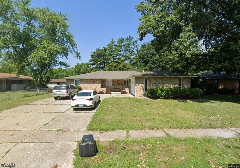
345 Norwalk Rd Springfield, IL 62704
Pasfield Park Place NeighborhoodEstimated Value: $208,000 - $253,000
2
Beds
1
Bath
2,000
Sq Ft
$114/Sq Ft
Est. Value
About This Home
This home is located at 345 Norwalk Rd, Springfield, IL 62704 and is currently estimated at $227,012, approximately $113 per square foot. 345 Norwalk Rd is a home located in Sangamon County with nearby schools including Dubois Elementary School, U.S. Grant Middle School, and Springfield High School.
Ownership History
Date
Name
Owned For
Owner Type
Purchase Details
Closed on
Oct 20, 2025
Sold by
Jovic Properties Llc
Bought by
Tl Holdings Group Llc
Current Estimated Value
Home Financials for this Owner
Home Financials are based on the most recent Mortgage that was taken out on this home.
Original Mortgage
$384,000
Outstanding Balance
$384,000
Interest Rate
6.5%
Mortgage Type
New Conventional
Estimated Equity
-$156,988
Purchase Details
Closed on
Feb 14, 2011
Purchase Details
Closed on
Feb 26, 2009
Create a Home Valuation Report for This Property
The Home Valuation Report is an in-depth analysis detailing your home's value as well as a comparison with similar homes in the area
Home Values in the Area
Average Home Value in this Area
Purchase History
| Date | Buyer | Sale Price | Title Company |
|---|---|---|---|
| Tl Holdings Group Llc | $384,000 | Illinois Real Estate Title | |
| -- | -- | -- | |
| -- | $125,000 | -- |
Source: Public Records
Mortgage History
| Date | Status | Borrower | Loan Amount |
|---|---|---|---|
| Open | Tl Holdings Group Llc | $384,000 |
Source: Public Records
Tax History
| Year | Tax Paid | Tax Assessment Tax Assessment Total Assessment is a certain percentage of the fair market value that is determined by local assessors to be the total taxable value of land and additions on the property. | Land | Improvement |
|---|---|---|---|---|
| 2024 | $5,325 | $63,392 | $10,472 | $52,920 |
| 2023 | $5,119 | $57,903 | $9,565 | $48,338 |
| 2022 | $4,876 | $54,415 | $9,073 | $45,342 |
| 2021 | $4,714 | $52,377 | $8,733 | $43,644 |
| 2020 | $4,621 | $52,456 | $8,746 | $43,710 |
| 2019 | $4,535 | $52,273 | $8,715 | $43,558 |
| 2018 | $3,757 | $44,469 | $8,674 | $35,795 |
| 2017 | $3,679 | $43,894 | $8,562 | $35,332 |
| 2016 | $3,607 | $43,254 | $8,437 | $34,817 |
| 2015 | $3,572 | $42,737 | $8,336 | $34,401 |
| 2014 | $3,541 | $42,461 | $8,282 | $34,179 |
| 2013 | $3,462 | $42,735 | $8,282 | $34,453 |
Source: Public Records
Map
Nearby Homes
- 2309 W Lawrence Ave
- 107 Collier Dr
- 2138 W Lawrence Ave
- 2134 W Lawrence Ave
- 2308 Westview Dr
- 337 S Durkin Dr
- 160 S Durkin Dr Unit 4
- 2028 Parkview Dr
- 2553 Chapel Hill Dr
- 29 N Oxford Rd
- 504 Brandywine Rd
- 1921 Jeanette Ln Unit 2
- 1910 Jeanette Ln Unit 2
- 16 Inverness Rd
- 2612 Cedar Pond Dr
- 3116 Kensington Dr
- 49 Bellerive Rd
- 3229 W Point Dr
- 1621 Seton Dr
- 2102 W Jefferson St
- 341 Norwalk Rd
- 339 Norwalk Rd
- 2431 W Lawrence Ave
- 344 Norwalk Rd
- 2435 W Lawrence Ave
- 328 Astoria Rd
- 342 Norwalk Rd
- 335 Norwalk Rd
- 340 Norwalk Rd
- 324 Astoria Rd
- 2437 W Lawrence Ave
- 2421 W Lawrence Ave
- 323 Norwalk Rd
- 2423 W Lawrence Ave
- 336 Norwalk Rd
- 334 Norwalk Rd
- 332 Astoria Rd
- 331 Norwalk Rd
- 332 Norwalk Rd
- 320 Astoria Rd
Your Personal Tour Guide
Ask me questions while you tour the home.