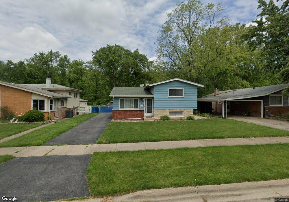
3450 218th St Matteson, IL 60443
Old Matteson NeighborhoodEstimated Value: $152,000 - $202,809
3
Beds
2
Baths
1,106
Sq Ft
$158/Sq Ft
Est. Value
About This Home
This home is located at 3450 218th St, Matteson, IL 60443 and is currently estimated at $174,702, approximately $157 per square foot. 3450 218th St is a home located in Cook County with nearby schools including Illinois School, Matteson Elementary School, and Sauk Elementary School.
Ownership History
Date
Name
Owned For
Owner Type
Purchase Details
Closed on
Jul 21, 2009
Sold by
Hsbc Bank Usa National Association
Bought by
Thomas Mary M
Current Estimated Value
Home Financials for this Owner
Home Financials are based on the most recent Mortgage that was taken out on this home.
Original Mortgage
$77,519
Interest Rate
5.19%
Mortgage Type
FHA
Purchase Details
Closed on
Mar 12, 2009
Sold by
Phillips
Bought by
Hsbc Bank Usa National Association
Create a Home Valuation Report for This Property
The Home Valuation Report is an in-depth analysis detailing your home's value as well as a comparison with similar homes in the area
Home Values in the Area
Average Home Value in this Area
Purchase History
| Date | Buyer | Sale Price | Title Company |
|---|---|---|---|
| Thomas Mary M | $79,000 | Wheatland Title Guaranty | |
| Hsbc Bank Usa National Association | -- | None Available |
Source: Public Records
Mortgage History
| Date | Status | Borrower | Loan Amount |
|---|---|---|---|
| Previous Owner | Thomas Mary M | $77,519 |
Source: Public Records
Tax History Compared to Growth
Tax History
| Year | Tax Paid | Tax Assessment Tax Assessment Total Assessment is a certain percentage of the fair market value that is determined by local assessors to be the total taxable value of land and additions on the property. | Land | Improvement |
|---|---|---|---|---|
| 2024 | $1,755 | $15,220 | $3,002 | $12,218 |
| 2023 | $2,006 | $15,220 | $3,002 | $12,218 |
| 2022 | $2,006 | $10,538 | $2,627 | $7,911 |
| 2021 | $2,132 | $10,538 | $2,627 | $7,911 |
| 2020 | $1,842 | $10,538 | $2,627 | $7,911 |
| 2019 | $2,069 | $12,352 | $2,439 | $9,913 |
| 2018 | $2,072 | $12,352 | $2,439 | $9,913 |
| 2017 | $1,955 | $12,352 | $2,439 | $9,913 |
| 2016 | $3,305 | $11,003 | $2,251 | $8,752 |
| 2015 | $3,172 | $11,003 | $2,251 | $8,752 |
| 2014 | $3,059 | $11,003 | $2,251 | $8,752 |
| 2013 | $2,863 | $11,141 | $2,251 | $8,890 |
Source: Public Records
Map
Nearby Homes
- 183 Washington St
- 433 Wildwood Dr
- 3704 Linden Rd
- 21945 Millard Ave
- 116 Walnut St
- 109 Walnut St
- 197 Washington St
- 408 Westgate Dr
- 21607 Main St
- 21628 Dogwood Rd Unit 1203
- 505 Wildwood Dr
- 303 Wayne St
- 506 Wildwood Dr
- 21612 Wildflower Rd Unit 113-4
- 510 Wildwood Dr
- 124 Wilson St
- 4083 Appleby Ct
- 354 Winona St
- 216 Washington St
- 114 Willow St