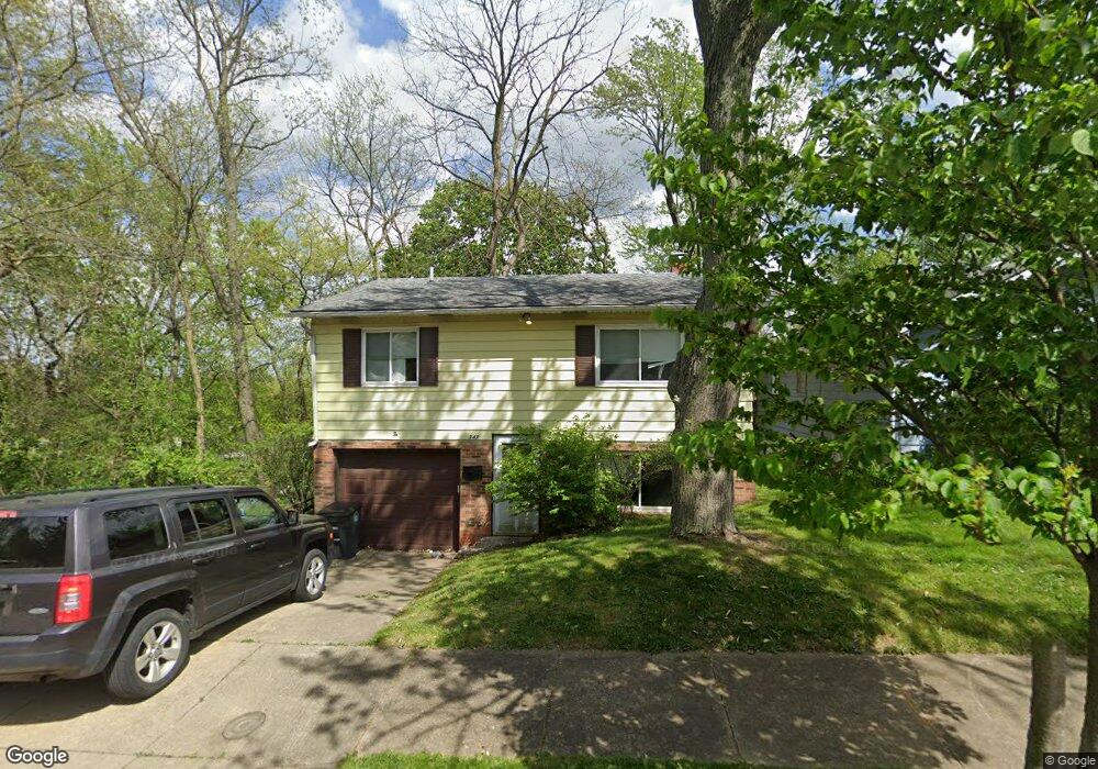
347 Wirth Ave Akron, OH 44312
Ellet NeighborhoodEstimated Value: $120,000 - $142,000
3
Beds
2
Baths
780
Sq Ft
$169/Sq Ft
Est. Value
About This Home
This home is located at 347 Wirth Ave, Akron, OH 44312 and is currently estimated at $132,076, approximately $169 per square foot. 347 Wirth Ave is a home located in Summit County with nearby schools including Ellet High School, Summit Academy Akron Elementary School, and Hatton Community Learning Center.
Ownership History
Date
Name
Owned For
Owner Type
Purchase Details
Closed on
May 21, 1996
Sold by
King Raymond
Bought by
Haboush James S and Haboush Mildred I
Current Estimated Value
Home Financials for this Owner
Home Financials are based on the most recent Mortgage that was taken out on this home.
Original Mortgage
$25,000
Interest Rate
7.86%
Mortgage Type
New Conventional
Create a Home Valuation Report for This Property
The Home Valuation Report is an in-depth analysis detailing your home's value as well as a comparison with similar homes in the area
Home Values in the Area
Average Home Value in this Area
Purchase History
| Date | Buyer | Sale Price | Title Company |
|---|---|---|---|
| Haboush James S | $68,000 | -- |
Source: Public Records
Mortgage History
| Date | Status | Borrower | Loan Amount |
|---|---|---|---|
| Closed | Haboush James S | $25,000 |
Source: Public Records
Tax History
| Year | Tax Paid | Tax Assessment Tax Assessment Total Assessment is a certain percentage of the fair market value that is determined by local assessors to be the total taxable value of land and additions on the property. | Land | Improvement |
|---|---|---|---|---|
| 2024 | $2,021 | $37,006 | $7,361 | $29,645 |
| 2023 | $2,021 | $37,006 | $7,361 | $29,645 |
| 2022 | $1,863 | $26,727 | $5,296 | $21,431 |
| 2021 | $1,865 | $26,727 | $5,296 | $21,431 |
| 2020 | $1,837 | $26,730 | $5,300 | $21,430 |
| 2019 | $1,863 | $24,640 | $5,300 | $19,340 |
| 2018 | $1,839 | $24,640 | $5,300 | $19,340 |
| 2017 | $1,637 | $24,640 | $5,300 | $19,340 |
| 2016 | $1,639 | $21,470 | $5,300 | $16,170 |
| 2015 | $1,637 | $21,470 | $5,300 | $16,170 |
| 2014 | $1,625 | $21,470 | $5,300 | $16,170 |
| 2013 | $1,838 | $24,090 | $5,300 | $18,790 |
Source: Public Records
Map
Nearby Homes
- 404 Wirth Ave
- 412 Stevenson Ave
- V/L Ellet Ave
- 2616 Terrace Ave
- 572 Cora Ave
- 601 Cora Ave
- 189 Pocantico Ave
- 2511 Ogden Ave
- 210 Davenport Ave
- 0 Kreiner Ave
- 6 Kreiner Ave
- 5 Kreiner Ave
- 124 Davenport Ave
- 114 Davenport Ave
- 147 Woolf Ave
- 3192 Mogadore Rd
- 40 Hyland Dr
- 81 Hyland Dr
- 640 Plainfield Rd
- 228 Hawk Ave
- 351 Wirth Ave
- 353 Wirth Ave
- 359 Wirth Ave
- 335 Wirth Ave
- 332 Stevenson Ave
- 320 Stevenson Ave
- 344 Wirth Ave
- 331 Wirth Ave
- 352 Wirth Ave
- 308 Stevenson Ave
- 356 Wirth Ave
- 363 Wirth Ave
- 304 Stevenson Ave
- 336 Wirth Ave
- 360 Wirth Ave
- 332 Wirth Ave
- 344 Stevenson Ave
- 300 Stevenson Ave
- 323 Wirth Ave
- 373 Wirth Ave
Your Personal Tour Guide
Ask me questions while you tour the home.