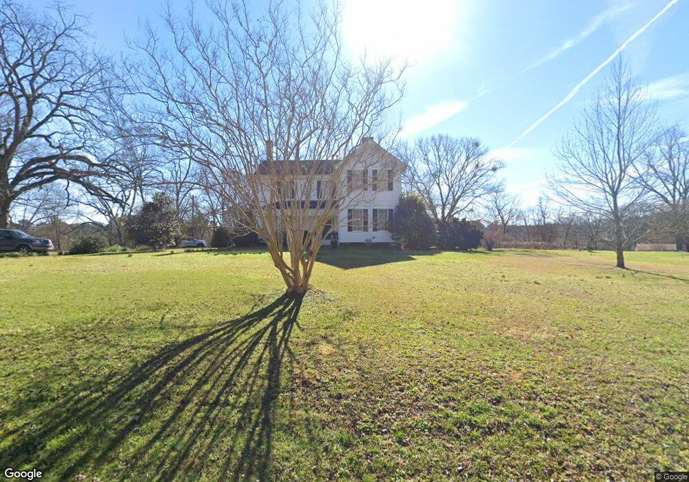
3471 Old Union Point Rd Union Point, GA 30669
Estimated Value: $305,000 - $714,487
3
Beds
3
Baths
3,396
Sq Ft
$148/Sq Ft
Est. Value
About This Home
This home is located at 3471 Old Union Point Rd, Union Point, GA 30669 and is currently estimated at $502,372, approximately $147 per square foot. 3471 Old Union Point Rd is a home located in Greene County with nearby schools including Greene County High School.
Ownership History
Date
Name
Owned For
Owner Type
Purchase Details
Closed on
Oct 4, 2002
Sold by
Vickers Marion H and Vickers Harrison,
Bought by
Vickers Marion Harrison
Current Estimated Value
Purchase Details
Closed on
Dec 9, 1993
Sold by
Harrison Marion
Bought by
Vickers Marion H and Vickers Harrison,
Purchase Details
Closed on
Jul 14, 1993
Sold by
Vickers Marion Harrison
Bought by
Harrison Marion
Purchase Details
Closed on
Jan 1, 1987
Sold by
Vickers Gary
Bought by
Vickers Marion Harrison
Purchase Details
Closed on
Jan 1, 1986
Sold by
Mcarthur William H and Mcarthur Geraldin
Bought by
Vickers Gary
Purchase Details
Closed on
Jan 1, 1977
Sold by
Federal Land Bank Of Columbia
Bought by
Mcarthur William H and Mcarthur Geraldin
Purchase Details
Closed on
Jan 1, 1975
Sold by
Robert James P
Bought by
Hayes Jack Rondal and Fran Greene
Purchase Details
Closed on
Jan 1, 1973
Sold by
Hill R G
Bought by
Robert James P
Purchase Details
Closed on
Jan 1, 1963
Bought by
Hill R G
Create a Home Valuation Report for This Property
The Home Valuation Report is an in-depth analysis detailing your home's value as well as a comparison with similar homes in the area
Home Values in the Area
Average Home Value in this Area
Purchase History
| Date | Buyer | Sale Price | Title Company |
|---|---|---|---|
| Vickers Marion Harrison | -- | -- | |
| Vickers Marion H | -- | -- | |
| Harrison Marion | -- | -- | |
| Vickers Marion Harrison | -- | -- | |
| Vickers Gary | -- | -- | |
| Mcarthur William H | -- | -- | |
| Federal Land Bank Of Columbia | -- | -- | |
| Hayes Jack Rondal | -- | -- | |
| Robert James P | -- | -- | |
| Hill R G | -- | -- |
Source: Public Records
Tax History Compared to Growth
Tax History
| Year | Tax Paid | Tax Assessment Tax Assessment Total Assessment is a certain percentage of the fair market value that is determined by local assessors to be the total taxable value of land and additions on the property. | Land | Improvement |
|---|---|---|---|---|
| 2025 | $381 | $264,920 | $120,720 | $144,200 |
| 2024 | $384 | $257,640 | $120,720 | $136,920 |
| 2023 | $247 | $228,880 | $99,720 | $129,160 |
| 2022 | $414 | $154,800 | $60,440 | $94,360 |
| 2021 | $420 | $147,280 | $60,440 | $86,840 |
| 2020 | $444 | $73,400 | $54,440 | $18,960 |
| 2019 | $447 | $73,400 | $54,440 | $18,960 |
| 2018 | $670 | $74,000 | $55,040 | $18,960 |
| 2017 | $631 | $74,081 | $55,061 | $19,020 |
| 2016 | $626 | $74,080 | $55,060 | $19,020 |
| 2015 | $597 | $74,080 | $55,061 | $19,020 |
| 2014 | $551 | $70,995 | $55,061 | $15,934 |
Source: Public Records
Map
Nearby Homes
- 0 S Rhodes St Unit 10618488
- 0 Washington Hwy Unit 7276060
- 1241 Old Siloam Rd
- 1041 Hillcrest Dr
- 0 Old Union Point Rd Unit 1 10557753
- 1581 Highway 77 S Hwy
- 215 Hunter St
- 1581 Highway 77 S
- 1251 Brick House Rd
- 1251 Brickhouse Rd
- 202 Veazey St
- 324 N Rhodes St
- 112 Hendry St
- 0 Woodland Ct Unit 10543600
- 1251 Adams Rd
- 0 Shady Side Ln
- 5401 Union Point Hwy
- 1201 Buffalo Lick Rd
- 0 Buffalo Lick Rd Unit 10551234
- 0 Buffalo Lick Rd Unit 10551325
- 0 Union Point Unit 20146502
- 4321 Union Point Hwy
- 1011 Country Club Dr
- 1031 Country Club Dr
- 1031 Country Club Dr
- 1051 Country Club Dr
- 3661 Old Union Point Rd
- 1030 Country Club Dr
- 1030 Country Club Dr
- 1040 Country Club Ln
- 4421 Union Point Hwy
- 1050 Country Club Dr
- 1111 Country Club Dr
- 4431 Lamb Ave
- 4441 Lamb Ave
- 1131 Country Club Dr
- 1080 Country Club Dr
- 4461 Lamb Ave
- 1120 Country Club Dr
- 1161 Country Club Dr