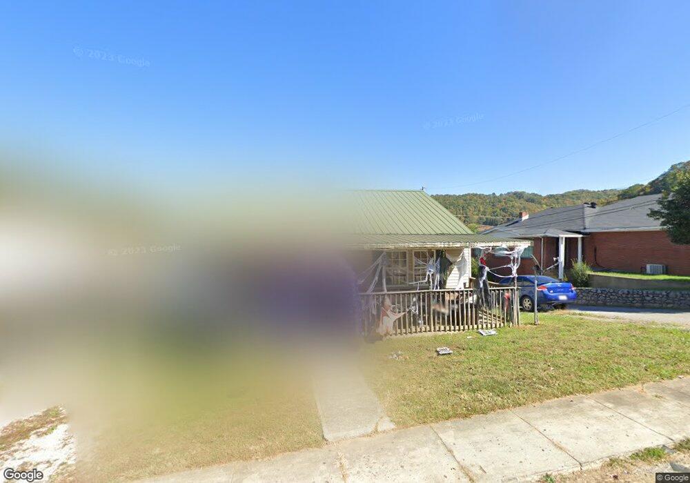
348 Pear St Hazard, KY 41701
Estimated Value: $111,000 - $122,000
3
Beds
--
Bath
--
Sq Ft
4,792
Sq Ft Lot
About This Home
This home is located at 348 Pear St, Hazard, KY 41701 and is currently estimated at $115,862. 348 Pear St is a home located in Perry County with nearby schools including Roy G. Eversole Elementary School, Hazard Middle School, and Hazard High School.
Ownership History
Date
Name
Owned For
Owner Type
Purchase Details
Closed on
Sep 17, 2024
Sold by
Biallas Darryl and Biallas Barbara S
Bought by
Biallas Enterprises Llc
Current Estimated Value
Purchase Details
Closed on
Feb 8, 2011
Sold by
Jpmc Specialty Mortgage Llc
Bought by
Biallas Barbara S and Biallas C.
Home Financials for this Owner
Home Financials are based on the most recent Mortgage that was taken out on this home.
Original Mortgage
$42,000
Interest Rate
4.66%
Purchase Details
Closed on
Aug 12, 2005
Sold by
Martin Maxine and Martin Florence Maxine
Bought by
Martin Florence Maxine and Martin Clarence
Home Financials for this Owner
Home Financials are based on the most recent Mortgage that was taken out on this home.
Original Mortgage
$127,500
Interest Rate
8.65%
Create a Home Valuation Report for This Property
The Home Valuation Report is an in-depth analysis detailing your home's value as well as a comparison with similar homes in the area
Home Values in the Area
Average Home Value in this Area
Purchase History
| Date | Buyer | Sale Price | Title Company |
|---|---|---|---|
| Biallas Enterprises Llc | -- | None Listed On Document | |
| Biallas Enterprises Llc | -- | None Listed On Document | |
| Biallas Enterprises Llc | -- | None Listed On Document | |
| Biallas Barbara S | $52,500 | -- | |
| Martin Florence Maxine | -- | -- |
Source: Public Records
Mortgage History
| Date | Status | Borrower | Loan Amount |
|---|---|---|---|
| Previous Owner | Biallas Barbara S | $42,000 | |
| Previous Owner | Martin Florence Maxine | $127,500 |
Source: Public Records
Tax History
| Year | Tax Paid | Tax Assessment Tax Assessment Total Assessment is a certain percentage of the fair market value that is determined by local assessors to be the total taxable value of land and additions on the property. | Land | Improvement |
|---|---|---|---|---|
| 2025 | $595 | $52,500 | $0 | $0 |
| 2024 | $595 | $52,500 | $0 | $0 |
| 2023 | $595 | $52,500 | $15,000 | $37,500 |
| 2022 | $582 | $52,500 | $15,000 | $37,500 |
| 2021 | $582 | $52,500 | $15,000 | $37,500 |
| 2020 | $581 | $52,500 | $15,000 | $37,500 |
| 2019 | $566 | $52,500 | $15,000 | $37,500 |
| 2018 | $548 | $52,500 | $15,000 | $37,500 |
| 2017 | $52,500 | $52,500 | $15,000 | $37,500 |
| 2016 | $52,500 | $52,500 | $15,000 | $37,500 |
| 2015 | $52,500 | $52,500 | $15,000 | $37,500 |
| 2013 | $508 | $52,500 | $15,000 | $37,500 |
Source: Public Records
Map
Nearby Homes
- 157 Alto St
- 2517 N Main St
- 540 Skyline Dr
- 272 Chimney Rock Rd
- 208 Eversole St
- 148 Combs St
- 141 Eversole St
- 362 Poplar St
- 270 Rockaway St
- 300 Perry Circle Rd
- 131 Oak St
- 219 Perry Ave
- 0 E Main St
- 1000 Kentucky Blvd
- 21 Adams Ridge Rd
- 117 Spruce St
- 215 Argyll Cir
- 0 Elm Shoal Branch Rd
- 187 Meadow Brook Terrace
- 207 Rock Ridge Rd
Your Personal Tour Guide
Ask me questions while you tour the home.