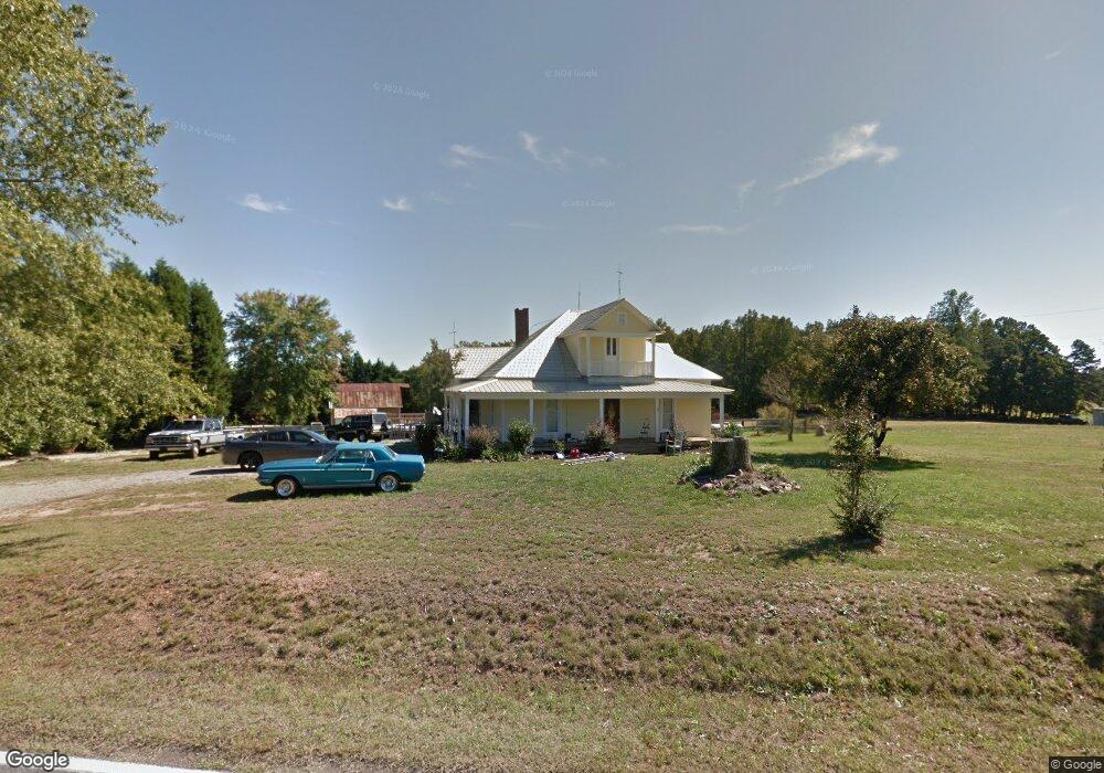
349 E Monbo Rd Statesville, NC 28677
Estimated Value: $353,000 - $418,000
2
Beds
1
Bath
2,998
Sq Ft
$131/Sq Ft
Est. Value
About This Home
This home is located at 349 E Monbo Rd, Statesville, NC 28677 and is currently estimated at $392,853, approximately $131 per square foot. 349 E Monbo Rd is a home located in Iredell County with nearby schools including Troutman Elementary School, Troutman Middle School, and South Iredell High School.
Ownership History
Date
Name
Owned For
Owner Type
Purchase Details
Closed on
Oct 4, 2002
Sold by
Little Brian Keith and Little Selina Moore
Bought by
Todd Michael K and Todd Jean
Current Estimated Value
Home Financials for this Owner
Home Financials are based on the most recent Mortgage that was taken out on this home.
Original Mortgage
$125,400
Outstanding Balance
$52,995
Interest Rate
6.27%
Estimated Equity
$339,858
Purchase Details
Closed on
Jul 1, 1997
Purchase Details
Closed on
Apr 1, 1996
Purchase Details
Closed on
Oct 1, 1995
Create a Home Valuation Report for This Property
The Home Valuation Report is an in-depth analysis detailing your home's value as well as a comparison with similar homes in the area
Home Values in the Area
Average Home Value in this Area
Purchase History
| Date | Buyer | Sale Price | Title Company |
|---|---|---|---|
| Todd Michael K | $132,500 | -- | |
| -- | $1,000 | -- | |
| -- | $69,500 | -- | |
| -- | -- | -- |
Source: Public Records
Mortgage History
| Date | Status | Borrower | Loan Amount |
|---|---|---|---|
| Open | Todd Michael K | $125,400 |
Source: Public Records
Tax History Compared to Growth
Tax History
| Year | Tax Paid | Tax Assessment Tax Assessment Total Assessment is a certain percentage of the fair market value that is determined by local assessors to be the total taxable value of land and additions on the property. | Land | Improvement |
|---|---|---|---|---|
| 2024 | $1,930 | $303,080 | $73,410 | $229,670 |
| 2023 | $1,878 | $303,080 | $73,410 | $229,670 |
| 2022 | $1,320 | $197,620 | $31,740 | $165,880 |
| 2021 | $1,006 | $151,320 | $31,740 | $119,580 |
| 2020 | $1,006 | $151,320 | $31,740 | $119,580 |
| 2019 | $968 | $151,320 | $31,740 | $119,580 |
| 2018 | $912 | $143,850 | $31,740 | $112,110 |
| 2017 | $866 | $136,230 | $31,740 | $104,490 |
| 2016 | $866 | $136,230 | $31,740 | $104,490 |
| 2015 | $866 | $136,230 | $31,740 | $104,490 |
| 2014 | $803 | $136,500 | $31,740 | $104,760 |
Source: Public Records
Map
Nearby Homes
- 124 N Sina St
- 173 Wembury Ln
- 139 Jacobs Hill Place
- 129 Jacobs Hill Place
- 125 Jacobs Hill Place
- 144 Jacobs Hill Place
- 142 Jacobs Hill Place
- 134 Jacobs Hill Place
- 111 Sandypark Ct
- 113 Sandypark Ct
- 114 Sandypark Ct
- 116 Kennford Trail
- 112 Sandypark Ct
- 104 Sandypark Ct
- 101 Rills Crossing Way
- 105 Rills Crossing Way
- 109 Rills Crossing Way
- 117 Rills Crossing Way
- 120 Rills Crossing Way
- 121 Rills Crossing Way
- 335 E Monbo Rd
- 365 E Monbo Rd
- 330 E Monbo Rd
- 332 E Monbo Rd
- Lot 1 Stone House Ln
- 139 Wootie Dr
- 315 E Monbo Rd
- 146 Wootie Dr
- 120 N Sina St
- 00 E Monbo Rd Unit 6
- 00 E Monbo Rd Unit 5
- 00 E Monbo Rd Unit 4
- 00 E Monbo Rd Unit 3
- 00 E Monbo Rd Unit 2
- 00 E Monbo Rd Unit 1
- 00 E Monbo Rd
- 285 E Monbo Rd
- 155 Wootie Dr
- 112 N Sina St
- 172 Wembury Ln