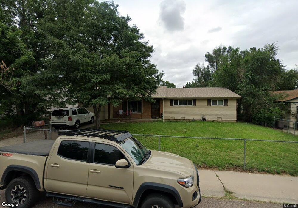
349 Everett Dr Colorado Springs, CO 80911
Security-Widefield NeighborhoodEstimated Value: $319,881 - $341,000
3
Beds
3
Baths
1,342
Sq Ft
$248/Sq Ft
Est. Value
About This Home
This home is located at 349 Everett Dr, Colorado Springs, CO 80911 and is currently estimated at $333,220, approximately $248 per square foot. 349 Everett Dr is a home located in El Paso County with nearby schools including Pinello Elementary School, Sproul Junior High School, and Widefield High School.
Ownership History
Date
Name
Owned For
Owner Type
Purchase Details
Closed on
Feb 11, 2014
Sold by
Jpmorgan Chase Bank National Association
Bought by
Secretary Of Housing & Urban Development
Current Estimated Value
Purchase Details
Closed on
Feb 4, 2014
Sold by
Marcum Robbie I and Marcum Nancy Lynn
Bought by
Jpmorgan Chase Bank National Association
Purchase Details
Closed on
Jun 26, 2009
Sold by
Brown Sonja E
Bought by
Marcum Robbie I and Marcum Nancy Lynn
Home Financials for this Owner
Home Financials are based on the most recent Mortgage that was taken out on this home.
Original Mortgage
$126,663
Interest Rate
4.84%
Mortgage Type
FHA
Purchase Details
Closed on
Jul 24, 1991
Bought by
Salazar Jim C
Purchase Details
Closed on
Jun 10, 1991
Bought by
Salazar Jim C
Purchase Details
Closed on
Dec 17, 1990
Bought by
Salazar Jim C
Create a Home Valuation Report for This Property
The Home Valuation Report is an in-depth analysis detailing your home's value as well as a comparison with similar homes in the area
Home Values in the Area
Average Home Value in this Area
Purchase History
| Date | Buyer | Sale Price | Title Company |
|---|---|---|---|
| Secretary Of Housing & Urban Development | -- | None Available | |
| Jpmorgan Chase Bank National Association | -- | None Available | |
| Marcum Robbie I | $129,000 | Security Title | |
| Salazar Jim C | $40,500 | -- | |
| Salazar Jim C | -- | -- | |
| Salazar Jim C | -- | -- |
Source: Public Records
Mortgage History
| Date | Status | Borrower | Loan Amount |
|---|---|---|---|
| Previous Owner | Marcum Robbie I | $126,663 |
Source: Public Records
Tax History Compared to Growth
Tax History
| Year | Tax Paid | Tax Assessment Tax Assessment Total Assessment is a certain percentage of the fair market value that is determined by local assessors to be the total taxable value of land and additions on the property. | Land | Improvement |
|---|---|---|---|---|
| 2025 | $1,501 | $23,990 | -- | -- |
| 2024 | $920 | $23,980 | $4,020 | $19,960 |
| 2023 | $920 | $23,980 | $4,020 | $19,960 |
| 2022 | $1,175 | $15,740 | $2,780 | $12,960 |
| 2021 | $1,268 | $16,200 | $2,860 | $13,340 |
| 2020 | $903 | $11,210 | $2,500 | $8,710 |
| 2019 | $898 | $11,210 | $2,500 | $8,710 |
| 2018 | $786 | $9,160 | $1,870 | $7,290 |
| 2017 | $795 | $9,160 | $1,870 | $7,290 |
| 2016 | $611 | $8,600 | $1,990 | $6,610 |
| 2015 | $627 | $8,600 | $1,990 | $6,610 |
| 2014 | $653 | $9,000 | $1,790 | $7,210 |
Source: Public Records
Map
Nearby Homes
- 317 Everett Dr
- 324 Davie Dr
- 605 Birch Dr
- 1604 Rosemont Dr
- 405 Birch Dr
- 257 Sherri Dr
- 4950 Elm Grove Dr
- 4935 Elm Grove Dr
- 4316 Yellow Dock Point
- 4790 Hennings Dr
- 4691 Pleasant Port View
- 217 Steven Dr
- 509 Inca Dr
- 521 Acoma Dr
- 213 Sumac Dr
- 4211 Little Rock View
- 1209 Rosemont Dr
- 4210 Little Rock View
- 5018 Rill Valley Way
- 4666 Hennings Dr