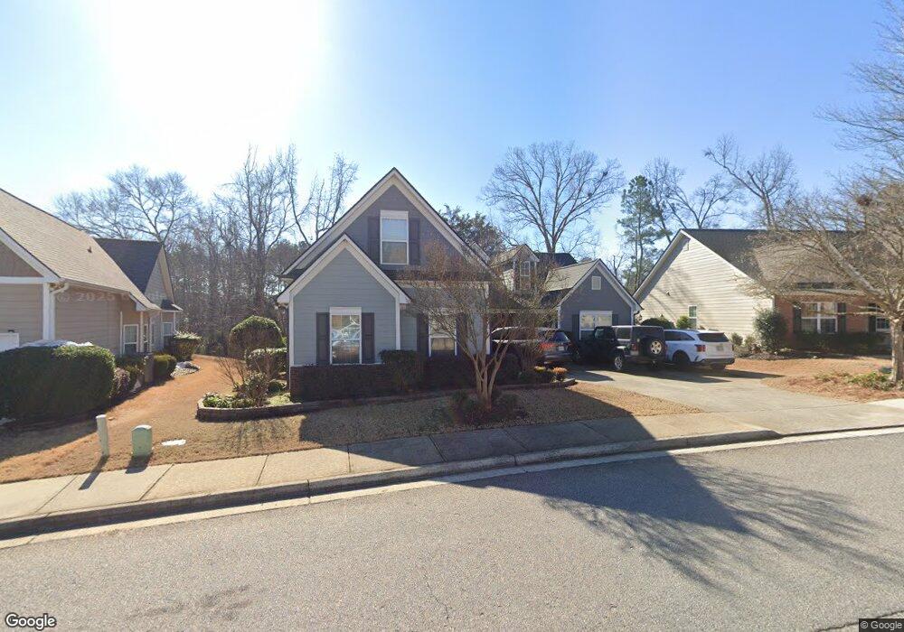
349 Meeler Cir Bogart, GA 30622
Estimated Value: $398,008 - $444,000
3
Beds
3
Baths
2,376
Sq Ft
$179/Sq Ft
Est. Value
About This Home
This home is located at 349 Meeler Cir, Bogart, GA 30622 and is currently estimated at $424,252, approximately $178 per square foot. 349 Meeler Cir is a home located in Clarke County with nearby schools including Cleveland Road Elementary School, Burney-Harris-Lyons Middle School, and Clarke Central High School.
Ownership History
Date
Name
Owned For
Owner Type
Purchase Details
Closed on
Mar 1, 2022
Sold by
Williams Barry A
Bought by
Rampey Philip and Rampey Melanie
Current Estimated Value
Home Financials for this Owner
Home Financials are based on the most recent Mortgage that was taken out on this home.
Original Mortgage
$342,000
Outstanding Balance
$317,513
Interest Rate
3.69%
Mortgage Type
New Conventional
Estimated Equity
$106,739
Purchase Details
Closed on
Dec 22, 2005
Sold by
Meeler Lake Builders Llc
Bought by
Williams Barry A and Williams Bonnie
Home Financials for this Owner
Home Financials are based on the most recent Mortgage that was taken out on this home.
Original Mortgage
$153,250
Interest Rate
6.19%
Mortgage Type
New Conventional
Purchase Details
Closed on
Jan 20, 2005
Sold by
Bomac Investments Llc
Bought by
Meridian Homes At and Meridian Lake Meeler
Create a Home Valuation Report for This Property
The Home Valuation Report is an in-depth analysis detailing your home's value as well as a comparison with similar homes in the area
Home Values in the Area
Average Home Value in this Area
Purchase History
| Date | Buyer | Sale Price | Title Company |
|---|---|---|---|
| Rampey Philip | $360,000 | -- | |
| Williams Barry A | $199,675 | -- | |
| Meridian Homes At | $4,294,000 | -- |
Source: Public Records
Mortgage History
| Date | Status | Borrower | Loan Amount |
|---|---|---|---|
| Open | Rampey Philip | $342,000 | |
| Previous Owner | Williams Barry A | $153,250 |
Source: Public Records
Tax History Compared to Growth
Tax History
| Year | Tax Paid | Tax Assessment Tax Assessment Total Assessment is a certain percentage of the fair market value that is determined by local assessors to be the total taxable value of land and additions on the property. | Land | Improvement |
|---|---|---|---|---|
| 2025 | $4,171 | $155,184 | $12,000 | $143,184 |
| 2024 | $4,171 | $142,701 | $12,000 | $130,701 |
| 2023 | $3,960 | $143,695 | $12,000 | $131,695 |
| 2022 | $2,609 | $119,744 | $12,000 | $107,744 |
| 2021 | $2,559 | $105,879 | $12,000 | $93,879 |
| 2020 | $2,455 | $98,301 | $12,000 | $86,301 |
| 2019 | $2,303 | $85,794 | $12,000 | $73,794 |
| 2018 | $2,245 | $81,627 | $12,000 | $69,627 |
| 2017 | $2,189 | $77,588 | $10,400 | $67,188 |
| 2016 | $2,115 | $72,285 | $10,400 | $61,885 |
| 2015 | $2,141 | $72,965 | $10,400 | $62,565 |
| 2014 | $2,006 | $68,890 | $10,400 | $58,490 |
Source: Public Records
Map
Nearby Homes
- 212 Meeler Cir
- 241 Meeler Cir
- 150 Callaway Dr
- 637 Huntington Rd Unit B1
- 211 Littleton Way
- 240 Cleveland Rd Unit 105
- 470 Huntington Rd Unit 5
- 532 Huntington Rd Unit 7
- 141 Huntington Shoals Dr
- 170 Huntington Ct
- 240 W Huntington Rd
- 190 W Huntington Rd
- 178 Ben Burton Cir
- 682 Chesterfield Rd
- 212 Huntington Shoals Dr
- 256 Cherokee Ridge
- 165 Mill Center Blvd Unit 208
- 165 Mill Center Blvd Unit 104