Estimated Value: $170,966 - $199,000
3
Beds
2
Baths
1,629
Sq Ft
$113/Sq Ft
Est. Value
About This Home
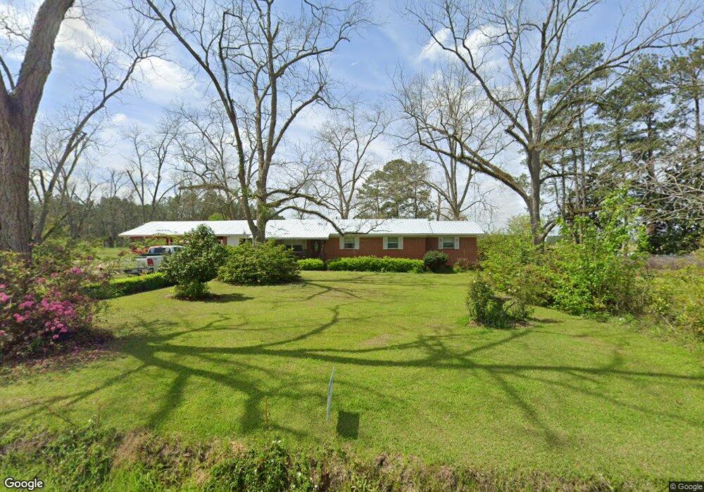
This home is located at 349 Robert Willis Rd, Cairo, GA 39827 and is currently estimated at $183,992, approximately $112 per square foot. 349 Robert Willis Rd is a home located in Grady County with nearby schools including Cairo High School.
Ownership History
Date
Name
Owned For
Owner Type
Purchase Details
Closed on
Aug 2, 2021
Sold by
Gainous Connie M
Bought by
Mcguire Marty L and Mcguire Angela B
Current Estimated Value
Purchase Details
Closed on
Oct 6, 2014
Sold by
Gainous Jeffrey Lance
Bought by
Gainous Bryan Lex and Gainous Connie M
Purchase Details
Closed on
Oct 30, 2012
Sold by
Mcguire Eva P
Bought by
Gainous Marty L and Mcguire Angela B
Purchase Details
Closed on
Sep 19, 1994
Sold by
Mcguire Henry and Mcguire Eva P
Bought by
Mcguire Eva P
Purchase Details
Closed on
Dec 20, 1965
Sold by
Harper Myrtle N
Bought by
Mcguire Henry and Mcguire Eva P
Create a Home Valuation Report for This Property
The Home Valuation Report is an in-depth analysis detailing your home's value as well as a comparison with similar homes in the area
Purchase History
| Date | Buyer | Sale Price | Title Company |
|---|---|---|---|
| Mcguire Marty L | -- | -- | |
| Gainous Bryan Lex | -- | -- | |
| Gainous Marty L | -- | -- | |
| Mcguire Eva P | -- | -- | |
| Mcguire Henry | -- | -- |
Source: Public Records
Tax History
| Year | Tax Paid | Tax Assessment Tax Assessment Total Assessment is a certain percentage of the fair market value that is determined by local assessors to be the total taxable value of land and additions on the property. | Land | Improvement |
|---|---|---|---|---|
| 2024 | $1,581 | $54,810 | $7,445 | $47,365 |
| 2023 | $1,020 | $35,139 | $4,095 | $31,044 |
| 2022 | $1,020 | $35,139 | $4,095 | $31,044 |
| 2021 | $1,023 | $35,139 | $4,095 | $31,044 |
| 2020 | $1,027 | $35,139 | $4,095 | $31,044 |
| 2019 | $1,027 | $35,139 | $4,095 | $31,044 |
| 2018 | $964 | $35,139 | $4,095 | $31,044 |
| 2017 | $918 | $35,139 | $4,095 | $31,044 |
| 2016 | $787 | $30,245 | $4,095 | $26,150 |
| 2015 | $777 | $30,245 | $4,095 | $26,150 |
| 2014 | $778 | $30,245 | $4,095 | $26,150 |
| 2013 | -- | $29,424 | $5,760 | $23,664 |
Source: Public Records
Map
Nearby Homes
- 414 Woodland Rd
- 00 State Route 188
- 0 State Route 188
- 408 Bay Tree Rd NE
- 0 20th St NE
- 00 20th St NE
- 2690 U S 84
- 78.6 Ac Strickland Rd
- 66 22nd St NE
- 3136 State Route 188
- 21 24th St NE
- 2975 U S 84
- 1420 Parallel Dr NW
- 3109 U S 84
- 3109 U S 84
- 711 2nd Ave NE
- 000 15th Ave Nw -- Tract 2
- 000 15th Ave Nw -- Tract 1
- 322 Woodridge Ln
- 333 + 2 Woodridge Ln
- 0 Harper Rd
- 342 Robert Willis Rd
- 358 Robert Willis Rd
- 388 Harper Rd
- 373 Harper Rd
- 317 Robert Willis Rd
- 312 Harper Rd
- 312 Harper Rd Unit Lots
- 312 Harper Rd
- 408 Harper Rd
- 289 Robert Willis Rd
- 292 Harper Rd
- 424 Harper Rd
- 277 Harper Rd
- 271 Robert Willis Rd
- 418 Harper Rd
- 272 Robert Willis Rd
- 450 Harper Rd
- 450 Harper Rd Unit C,D&E
- 263 Harper Rd
Your Personal Tour Guide
Ask me questions while you tour the home.