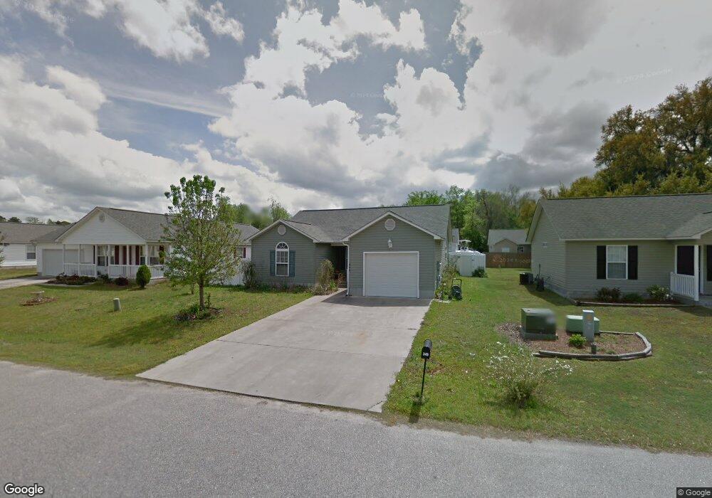
349 Sean River Rd Conway, SC 29526
Estimated Value: $236,000 - $248,000
3
Beds
2
Baths
1,354
Sq Ft
$179/Sq Ft
Est. Value
About This Home
This home is located at 349 Sean River Rd, Conway, SC 29526 and is currently estimated at $242,895, approximately $179 per square foot. 349 Sean River Rd is a home located in Horry County with nearby schools including Kingston Elementary School, Conway Middle School, and Conway High School.
Ownership History
Date
Name
Owned For
Owner Type
Purchase Details
Closed on
Oct 15, 2013
Sold by
Estate Of Marion M Terhaar
Bought by
Terhaar Dennis C and Terhaar George J
Current Estimated Value
Purchase Details
Closed on
Feb 3, 2005
Sold by
Martin Wesley A
Bought by
Sizemore Tammy R
Home Financials for this Owner
Home Financials are based on the most recent Mortgage that was taken out on this home.
Original Mortgage
$106,900
Interest Rate
5.69%
Mortgage Type
Balloon
Purchase Details
Closed on
Sep 2, 2004
Sold by
Majors Frederick F
Bought by
Martin Wesley A
Create a Home Valuation Report for This Property
The Home Valuation Report is an in-depth analysis detailing your home's value as well as a comparison with similar homes in the area
Home Values in the Area
Average Home Value in this Area
Purchase History
| Date | Buyer | Sale Price | Title Company |
|---|---|---|---|
| Terhaar Dennis C | -- | -- | |
| Sizemore Tammy R | $106,900 | -- | |
| Martin Wesley A | $40,000 | -- |
Source: Public Records
Mortgage History
| Date | Status | Borrower | Loan Amount |
|---|---|---|---|
| Previous Owner | Sizemore Tammy R | $106,900 |
Source: Public Records
Tax History Compared to Growth
Tax History
| Year | Tax Paid | Tax Assessment Tax Assessment Total Assessment is a certain percentage of the fair market value that is determined by local assessors to be the total taxable value of land and additions on the property. | Land | Improvement |
|---|---|---|---|---|
| 2024 | $1,597 | $14,428 | $3,599 | $10,829 |
| 2023 | $1,597 | $6,521 | $1,322 | $5,199 |
| 2021 | $1,476 | $14,475 | $2,736 | $11,739 |
| 2020 | $1,382 | $14,475 | $2,736 | $11,739 |
| 2019 | $1,382 | $14,475 | $2,736 | $11,739 |
| 2018 | $1,250 | $9,923 | $1,995 | $7,928 |
| 2017 | $1,235 | $8,688 | $760 | $7,928 |
| 2016 | -- | $8,688 | $760 | $7,928 |
| 2015 | $1,235 | $3,780 | $760 | $3,020 |
| 2014 | $1,195 | $3,780 | $760 | $3,020 |
Source: Public Records
Map
Nearby Homes
- 361 Sean River Rd
- 422 Sean River Rd Unit St. Annes Oaks
- 232 Oak Lea Dr
- 1911 Abba Ct
- Oliver II Plan at Grissett Landing
- Wisteria II Plan at Grissett Landing
- Montague II Plan at Grissett Landing
- Barnard II Plan at Grissett Landing
- Darcy II Plan at Grissett Landing
- Courtney II Plan at Grissett Landing
- Monaco II Plan at Grissett Landing
- 131 Grissett Lake Dr
- 242 Williamson Lake Cir
- 1021 Brick Point Ct
- 1519 Wood Stork Dr
- 544 Honeyhill Loop
- 544 Honeyhill Loop Unit Lot 32
- 459 Honeyhill Loop
- 2004 Mocha Ct
- 533 Honeyhill Loop Unit Lot 78
- 345 Sean River Rd
- 353 Sean River Rd
- TBD Sean River Rd
- 341 Sean River Rd
- 419 Sean River Rd
- 357 Sean River Rd
- 415 Sean River Rd
- 423 Sean River Rd
- 423 Sean River Rd Unit Lot 84 St Anne's Oak
- 427 Sean River Rd
- 348 Sean River Rd
- 411 Sean River Rd
- 337 Sean River Rd
- 344 Sean River Rd
- 340 Sean River Rd
- 354 Sean River Rd
- 431 Sean River Rd
- 333 Sean River Rd
- 407 Sean River Rd
- 358 Sean River Rd Unit St. Anne Oaks