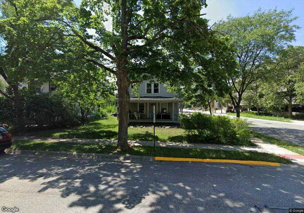
349 Sylvia St West Lafayette, IN 47906
Estimated Value: $320,000 - $389,000
--
Bed
--
Bath
1,346
Sq Ft
$263/Sq Ft
Est. Value
About This Home
This home is located at 349 Sylvia St, West Lafayette, IN 47906 and is currently estimated at $353,765, approximately $262 per square foot. 349 Sylvia St is a home located in Tippecanoe County with nearby schools including West Lafayette Intermediate School, West Lafayette Elementary School, and West Lafayette Junior/Senior High School.
Ownership History
Date
Name
Owned For
Owner Type
Purchase Details
Closed on
Sep 25, 2025
Sold by
Hack John J and Hack Stacey A
Bought by
Hack John J and Hack Stacey A
Current Estimated Value
Purchase Details
Closed on
Feb 24, 2023
Sold by
Hack John J and Hack Stacey A
Bought by
Hack John J and Hack Stacey A
Purchase Details
Closed on
Mar 27, 2018
Sold by
Hack Ii John J and Hack Stacy A
Bought by
Hack Ii John J and Hack Stacy A
Purchase Details
Closed on
Apr 29, 2016
Sold by
Balensiefer Dennis E and Balensiefer Barbra A
Bought by
Hack Ii John J and Hack Stacey A
Purchase Details
Closed on
Sep 26, 2011
Sold by
Johnston Samuel A and Johnston Nancy J
Bought by
Balensiefer Dennis E and Balensiefer Barbra A
Home Financials for this Owner
Home Financials are based on the most recent Mortgage that was taken out on this home.
Original Mortgage
$96,650
Interest Rate
4.14%
Mortgage Type
New Conventional
Purchase Details
Closed on
Oct 20, 2004
Sold by
Johnston Samuel A and Johnston Nancy J
Bought by
Johnston Samuel A and Johnston Nancy J
Create a Home Valuation Report for This Property
The Home Valuation Report is an in-depth analysis detailing your home's value as well as a comparison with similar homes in the area
Home Values in the Area
Average Home Value in this Area
Purchase History
| Date | Buyer | Sale Price | Title Company |
|---|---|---|---|
| Hack John J | -- | None Listed On Document | |
| Hack John J | -- | -- | |
| Hack Ii John J | -- | -- | |
| Hack Ii John J | -- | -- | |
| Balensiefer Dennis E | -- | None Available | |
| Johnston Samuel A | -- | -- |
Source: Public Records
Mortgage History
| Date | Status | Borrower | Loan Amount |
|---|---|---|---|
| Previous Owner | Balensiefer Dennis E | $96,650 |
Source: Public Records
Tax History Compared to Growth
Tax History
| Year | Tax Paid | Tax Assessment Tax Assessment Total Assessment is a certain percentage of the fair market value that is determined by local assessors to be the total taxable value of land and additions on the property. | Land | Improvement |
|---|---|---|---|---|
| 2024 | $2,981 | $250,300 | $61,000 | $189,300 |
| 2023 | $2,005 | $187,000 | $61,000 | $126,000 |
| 2022 | $2,132 | $180,000 | $61,000 | $119,000 |
| 2021 | $3,811 | $160,700 | $61,000 | $99,700 |
| 2020 | $1,321 | $123,600 | $61,000 | $62,600 |
| 2019 | $1,261 | $121,200 | $53,400 | $67,800 |
| 2018 | $1,281 | $121,200 | $53,400 | $67,800 |
| 2017 | $2,861 | $120,600 | $53,400 | $67,200 |
| 2016 | $3,754 | $158,300 | $53,400 | $104,900 |
| 2014 | $3,550 | $149,700 | $53,400 | $96,300 |
| 2013 | $3,525 | $148,600 | $53,400 | $95,200 |
Source: Public Records
Map
Nearby Homes
- 516 Robinson St
- 237 E Sunset Ln
- 845 Rose St
- 1220 Ravinia Rd
- 231 Schilling St
- 320 Brown St
- 320 Brown St Unit 312
- 416 Catherwood Dr
- 509 Carrolton Blvd
- 701 Carrolton Blvd
- 500 Carrolton Blvd
- 1909 Indian Trail Dr
- 1912 Indian Trail Dr
- 802 Tippecanoe St
- 511 N 7th St
- 105 Parkerwood Ln
- 107 Parkerwood Ln
- 1868 N River Rd
- 629 North St
- 132 Parkerwood Ln