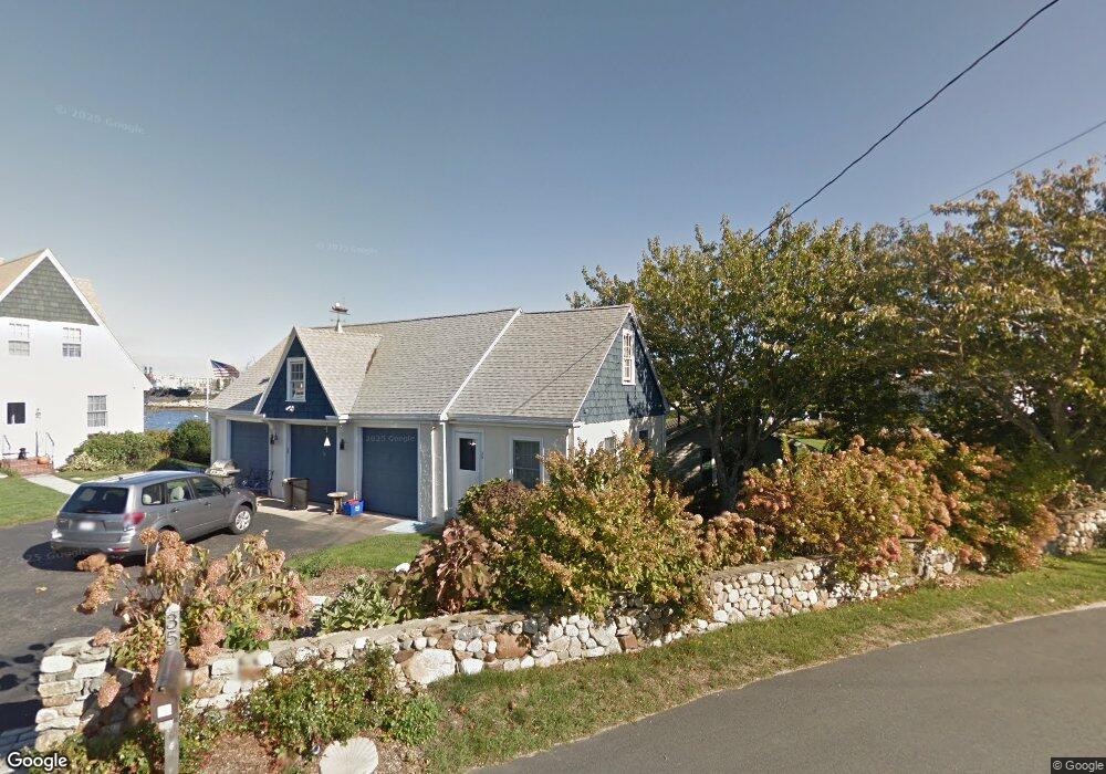
35 Benedict Rd Bourne, MA 2532
Estimated Value: $1,571,000 - $2,172,000
Studio
--
Bath
--
Sq Ft
0.41
Acres
About This Home
This home is located at 35 Benedict Rd, Bourne, MA 2532 and is currently estimated at $1,892,342. 35 Benedict Rd is a home located in Barnstable County with nearby schools including Bourne High School and St Margaret Regional School.
Ownership History
Date
Name
Owned For
Owner Type
Purchase Details
Closed on
Dec 15, 2022
Sold by
Tarantino
Bought by
Patricia Tarantino T and Patricia Tarantino
Current Estimated Value
Purchase Details
Closed on
Jul 12, 2007
Sold by
Shaw Howard W and Shaw Nancy H
Bought by
Tarantino
Create a Home Valuation Report for This Property
The Home Valuation Report is an in-depth analysis detailing your home's value as well as a comparison with similar homes in the area
Purchase History
| Date | Buyer | Sale Price | Title Company |
|---|---|---|---|
| Patricia Tarantino T | -- | None Available | |
| Patricia Tarantino T | -- | None Available | |
| Tarantino | $1,070,000 | -- | |
| Tarantino | $1,070,000 | -- |
Source: Public Records
Mortgage History
| Date | Status | Borrower | Loan Amount |
|---|---|---|---|
| Previous Owner | Tarantino | $168,000 |
Source: Public Records
Tax History
| Year | Tax Paid | Tax Assessment Tax Assessment Total Assessment is a certain percentage of the fair market value that is determined by local assessors to be the total taxable value of land and additions on the property. | Land | Improvement |
|---|---|---|---|---|
| 2025 | $12,397 | $1,587,300 | $991,600 | $595,700 |
| 2024 | $12,122 | $1,511,500 | $944,300 | $567,200 |
| 2023 | $11,786 | $1,337,800 | $835,700 | $502,100 |
| 2022 | $11,484 | $1,138,200 | $739,600 | $398,600 |
| 2021 | $11,159 | $1,036,100 | $673,100 | $363,000 |
| 2020 | $11,041 | $1,028,000 | $666,700 | $361,300 |
| 2019 | $10,592 | $1,007,800 | $666,700 | $341,100 |
| 2018 | $10,117 | $959,900 | $635,000 | $324,900 |
| 2017 | $9,944 | $965,400 | $635,100 | $330,300 |
| 2016 | $9,732 | $957,900 | $635,100 | $322,800 |
| 2015 | $9,219 | $915,500 | $592,700 | $322,800 |
Source: Public Records
Map
Nearby Homes
- 35 Benedict Rd
- 5 Zoli Ln
- 203 County Rd
- 40-A Lafayette Ave
- 4 Van Bummel Rd
- 3 Fairway Dr Unit F
- 46 Holt Rd Unit A
- 46 Holt Rd
- 13 Laurel Hill Ct
- 36B Starboard Dr Unit 36E
- 36B Starboard Dr Unit 36G
- 36B Starboard Dr Unit 36C
- 36B Starboard Dr Unit 36A
- 36B Starboard Dr Unit 36D
- 36B Starboard Dr Unit 36B
- 36B Starboard Dr Unit 36F
- 36B Starboard Dr Unit 36H
- 23 Starboard Dr Unit Lot 50
- 5 Sea Knoll Ct
- 44 Cotuit Rd
Your Personal Tour Guide
Ask me questions while you tour the home.