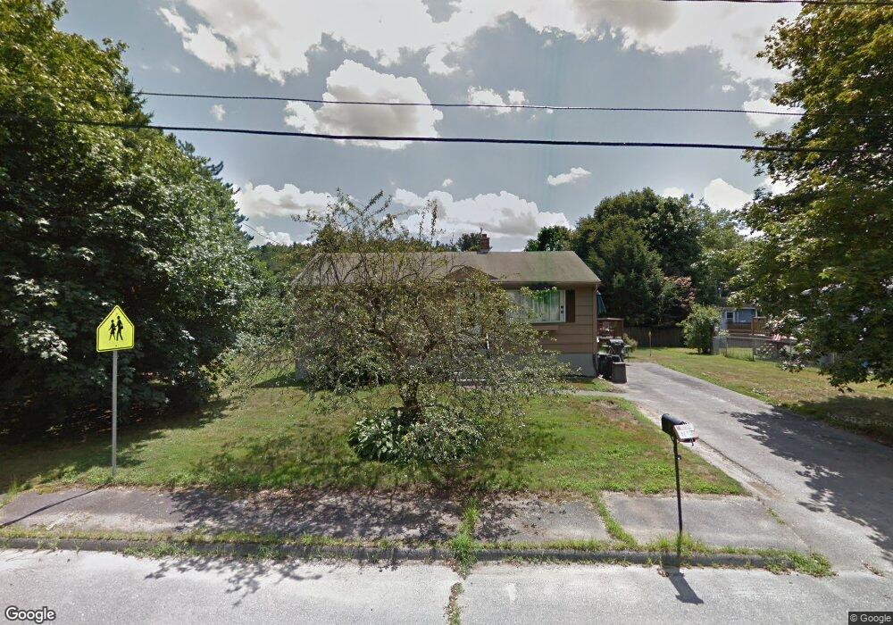
35 Burns Rd Marlborough, MA 01752
Estimated Value: $510,215 - $551,000
3
Beds
1
Bath
960
Sq Ft
$556/Sq Ft
Est. Value
About This Home
This home is located at 35 Burns Rd, Marlborough, MA 01752 and is currently estimated at $533,304, approximately $555 per square foot. 35 Burns Rd is a home located in Middlesex County with nearby schools including Marlborough High School, Advanced Math & Science Academy, and St. Bernadette School.
Ownership History
Date
Name
Owned For
Owner Type
Purchase Details
Closed on
Jun 19, 2023
Sold by
Robbins Kenneth W
Bought by
Kenneth W Robbins T W and Kenneth Robbins
Current Estimated Value
Purchase Details
Closed on
Aug 28, 1987
Sold by
Boyd Marilyn D
Bought by
Robbins Kenneth W
Home Financials for this Owner
Home Financials are based on the most recent Mortgage that was taken out on this home.
Original Mortgage
$124,600
Interest Rate
10.24%
Mortgage Type
Purchase Money Mortgage
Create a Home Valuation Report for This Property
The Home Valuation Report is an in-depth analysis detailing your home's value as well as a comparison with similar homes in the area
Home Values in the Area
Average Home Value in this Area
Purchase History
| Date | Buyer | Sale Price | Title Company |
|---|---|---|---|
| Kenneth W Robbins T W | -- | None Available | |
| Robbins Kenneth W | $138,500 | -- |
Source: Public Records
Mortgage History
| Date | Status | Borrower | Loan Amount |
|---|---|---|---|
| Previous Owner | Robbins Kenneth W | $124,600 | |
| Previous Owner | Robbins Kenneth W | $105,000 |
Source: Public Records
Tax History Compared to Growth
Tax History
| Year | Tax Paid | Tax Assessment Tax Assessment Total Assessment is a certain percentage of the fair market value that is determined by local assessors to be the total taxable value of land and additions on the property. | Land | Improvement |
|---|---|---|---|---|
| 2025 | $4,301 | $436,200 | $231,100 | $205,100 |
| 2024 | $4,318 | $421,700 | $210,100 | $211,600 |
| 2023 | $4,669 | $404,600 | $168,900 | $235,700 |
| 2022 | $4,563 | $347,800 | $160,900 | $186,900 |
| 2021 | $6,731 | $329,200 | $134,000 | $195,200 |
| 2020 | $4,499 | $317,300 | $127,600 | $189,700 |
| 2019 | $4,410 | $313,400 | $125,100 | $188,300 |
| 2018 | $3,957 | $270,500 | $99,500 | $171,000 |
| 2017 | $5,492 | $223,300 | $98,700 | $124,600 |
| 2016 | $3,241 | $211,300 | $98,700 | $112,600 |
| 2015 | $3,254 | $206,500 | $106,000 | $100,500 |
Source: Public Records
Map
Nearby Homes
- 55 Hurley Cir
- 72 Foley Rd
- 28 Sandini Rd
- 10 Masciarelli Dr
- 5 Damico Dr
- 0 Dudley St
- 120 Airport Blvd
- 115 Winter St
- 280 Elm St Unit A6
- 149 Clover Hill St
- 30A Winter Ave
- 76 Broad St
- 206 Millham St
- 30 Broad St Unit 104
- 28 Broad St Unit 203
- 287 Elm St
- 237 Millham St
- 156 Chestnut St
- 38 Gleason Street Extension
- 11 Fuller Dr