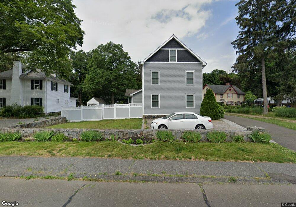
35 E Rocks Rd Norwalk, CT 06851
Woods Pond NeighborhoodEstimated Value: $848,000 - $1,069,000
4
Beds
4
Baths
2,217
Sq Ft
$426/Sq Ft
Est. Value
About This Home
This home is located at 35 E Rocks Rd, Norwalk, CT 06851 and is currently estimated at $945,475, approximately $426 per square foot. 35 E Rocks Rd is a home located in Fairfield County with nearby schools including Tracey School, West Rocks Middle School, and Norwalk High School.
Ownership History
Date
Name
Owned For
Owner Type
Purchase Details
Closed on
Oct 4, 2010
Sold by
Bank Of New York Mello
Bought by
Morales Aneury and Foltopoulos Stella
Current Estimated Value
Home Financials for this Owner
Home Financials are based on the most recent Mortgage that was taken out on this home.
Original Mortgage
$386,500
Interest Rate
4.44%
Purchase Details
Closed on
May 24, 2010
Sold by
Fiore John R
Bought by
Bank Of New York Mello
Purchase Details
Closed on
Nov 6, 2007
Sold by
Curran Thomas W and Curran Ruth L
Bought by
Cj Curran Llc
Purchase Details
Closed on
Jul 16, 2004
Sold by
Scalisi Joseph J and Scalisi Katherine
Bought by
James A Canevari Llc
Create a Home Valuation Report for This Property
The Home Valuation Report is an in-depth analysis detailing your home's value as well as a comparison with similar homes in the area
Home Values in the Area
Average Home Value in this Area
Purchase History
| Date | Buyer | Sale Price | Title Company |
|---|---|---|---|
| Morales Aneury | $525,000 | -- | |
| Morales Aneury | $525,000 | -- | |
| Bank Of New York Mello | -- | -- | |
| Bank Of New York Mello | -- | -- | |
| Cj Curran Llc | $3,600,000 | -- | |
| James A Canevari Llc | $250,000 | -- |
Source: Public Records
Mortgage History
| Date | Status | Borrower | Loan Amount |
|---|---|---|---|
| Open | James A Canevari Llc | $354,000 | |
| Closed | James A Canevari Llc | $386,500 |
Source: Public Records
Tax History
| Year | Tax Paid | Tax Assessment Tax Assessment Total Assessment is a certain percentage of the fair market value that is determined by local assessors to be the total taxable value of land and additions on the property. | Land | Improvement |
|---|---|---|---|---|
| 2025 | $13,206 | $551,500 | $186,470 | $365,030 |
| 2024 | $13,010 | $551,500 | $186,470 | $365,030 |
| 2023 | $10,470 | $416,110 | $142,440 | $273,670 |
| 2022 | $10,275 | $416,110 | $142,440 | $273,670 |
| 2021 | $10,007 | $416,110 | $142,440 | $273,670 |
| 2020 | $10,002 | $416,110 | $142,440 | $273,670 |
| 2019 | $9,722 | $416,110 | $142,440 | $273,670 |
| 2018 | $8,686 | $325,780 | $147,760 | $178,020 |
| 2017 | $8,388 | $325,790 | $147,760 | $178,030 |
| 2016 | $8,307 | $325,780 | $147,760 | $178,020 |
| 2015 | $8,285 | $325,780 | $147,760 | $178,020 |
| 2014 | $8,177 | $325,780 | $147,760 | $178,020 |
Source: Public Records
Map
Nearby Homes
- 75 Newtown Ave
- 10 Merrill Rd
- 11 Margaret St
- 71 Saddle Rd
- 34 Sunrise Hill Rd
- 4 Union Ave Unit 24
- 206 Sunrise Hill Rd Unit 206
- 226 Sunrise Hill Rd Unit 226
- 6 Clara Dr
- 3 Stonybrook Rd
- 29 High St Unit F
- 37 Murray St
- 50 Aiken St Unit 253
- 71 Aiken St Unit M1
- 71 Aiken St Unit C8
- 81 Wolfpit Ave Unit B3
- 48 Fair St
- 5 Tod Rd
- 10 Slocum St
- 152 E Rocks Rd
Your Personal Tour Guide
Ask me questions while you tour the home.