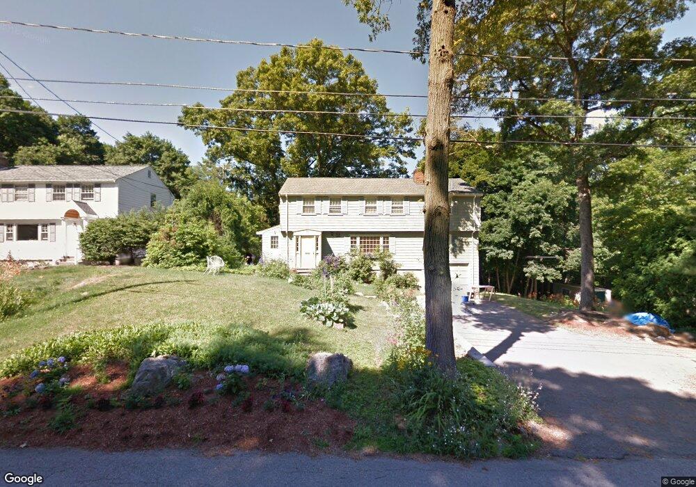
35 Highland Ave Lexington, MA 02421
Munroe Hill NeighborhoodEstimated Value: $1,594,000 - $2,422,000
4
Beds
4
Baths
2,747
Sq Ft
$724/Sq Ft
Est. Value
About This Home
This home is located at 35 Highland Ave, Lexington, MA 02421 and is currently estimated at $1,987,618, approximately $723 per square foot. 35 Highland Ave is a home located in Middlesex County with nearby schools including Bowman Elementary School, Jonas Clarke Middle School, and Lexington High School.
Ownership History
Date
Name
Owned For
Owner Type
Purchase Details
Closed on
Nov 18, 2004
Sold by
Herman Joanne S and Siff Joanne
Bought by
Pinnone Linda A and Tanner Russell P
Current Estimated Value
Home Financials for this Owner
Home Financials are based on the most recent Mortgage that was taken out on this home.
Original Mortgage
$333,700
Outstanding Balance
$166,749
Interest Rate
5.8%
Mortgage Type
Purchase Money Mortgage
Estimated Equity
$1,820,869
Purchase Details
Closed on
Jul 15, 1991
Sold by
Lee Francis F
Bought by
Lexington Rt
Create a Home Valuation Report for This Property
The Home Valuation Report is an in-depth analysis detailing your home's value as well as a comparison with similar homes in the area
Home Values in the Area
Average Home Value in this Area
Purchase History
| Date | Buyer | Sale Price | Title Company |
|---|---|---|---|
| Pinnone Linda A | $735,000 | -- | |
| Lexington Rt | $344,000 | -- |
Source: Public Records
Mortgage History
| Date | Status | Borrower | Loan Amount |
|---|---|---|---|
| Open | Pinnone Linda A | $333,700 | |
| Previous Owner | Lexington Rt | $40,000 | |
| Previous Owner | Lexington Rt | $15,000 | |
| Previous Owner | Lexington Rt | $250,000 |
Source: Public Records
Tax History Compared to Growth
Tax History
| Year | Tax Paid | Tax Assessment Tax Assessment Total Assessment is a certain percentage of the fair market value that is determined by local assessors to be the total taxable value of land and additions on the property. | Land | Improvement |
|---|---|---|---|---|
| 2025 | $19,788 | $1,618,000 | $1,025,000 | $593,000 |
| 2024 | $18,669 | $1,524,000 | $976,000 | $548,000 |
| 2023 | $18,213 | $1,401,000 | $888,000 | $513,000 |
| 2022 | $17,498 | $1,268,000 | $807,000 | $461,000 |
| 2021 | $3,891 | $1,219,000 | $768,000 | $451,000 |
| 2020 | $16,944 | $1,206,000 | $768,000 | $438,000 |
| 2019 | $16,266 | $1,152,000 | $732,000 | $420,000 |
| 2018 | $3,435 | $1,081,000 | $678,000 | $403,000 |
| 2017 | $6,851 | $1,047,000 | $645,000 | $402,000 |
| 2016 | $14,658 | $1,004,000 | $593,000 | $411,000 |
| 2015 | $13,701 | $922,000 | $539,000 | $383,000 |
| 2014 | $11,384 | $734,000 | $483,000 | $251,000 |
Source: Public Records
Map
Nearby Homes
- 42 Winthrop Rd
- 10 Eliot Rd
- 1437 Massachusetts Ave
- 223 Waltham St
- 1 Tricorne Rd
- 24 Grapevine Ave
- 20 Marrett Rd
- 32 Forest St
- 20 Loring Rd
- 1894 Massachusetts Ave
- 1900 Massachusetts Ave
- 21 Valleyfield St
- 36 Independence Ave
- 17 Prospect Hill Rd
- 25 Maple St
- 35 Tower Rd
- 69 Bridge St
- 30 Meriam St Unit 30
- 32 Edgewood Rd Unit 1
- 375 Marrett Rd