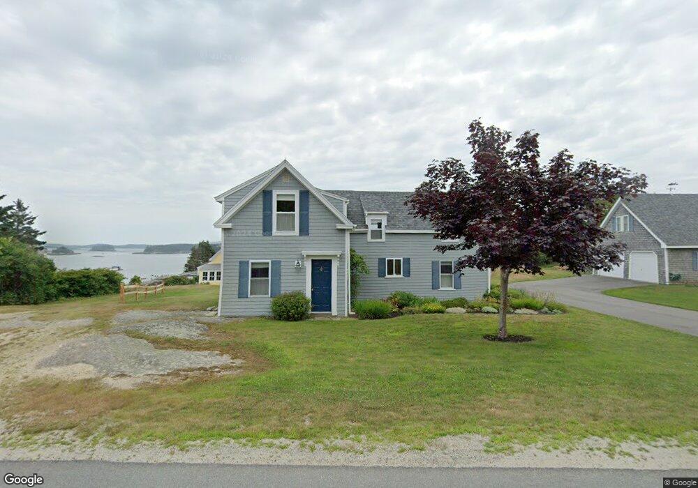
35 Indian Point Rd Stonington, ME 04681
Estimated Value: $503,000 - $914,000
--
Bed
--
Bath
--
Sq Ft
0.4
Acres
About This Home
This home is located at 35 Indian Point Rd, Stonington, ME 04681 and is currently estimated at $687,105. 35 Indian Point Rd is a home with nearby schools including Deer Isle-Stonington Elementary School, Deer Isle-Stonington High School, and The Heritage School.
Ownership History
Date
Name
Owned For
Owner Type
Purchase Details
Closed on
May 31, 2024
Sold by
Maccloskey Robert C Est and Jansen
Bought by
Hadnot Clayton L and Hadnot Ruth B
Current Estimated Value
Purchase Details
Closed on
Feb 9, 2005
Sold by
Sytsema Gerald D and Sytsema Gail J
Bought by
Sytsema Lt
Create a Home Valuation Report for This Property
The Home Valuation Report is an in-depth analysis detailing your home's value as well as a comparison with similar homes in the area
Home Values in the Area
Average Home Value in this Area
Purchase History
| Date | Buyer | Sale Price | Title Company |
|---|---|---|---|
| Hadnot Clayton L | $163,000 | None Available | |
| Hadnot Clayton L | $163,000 | None Available | |
| Sytsema Lt | -- | -- | |
| Sytsema Lt | -- | -- |
Source: Public Records
Tax History Compared to Growth
Tax History
| Year | Tax Paid | Tax Assessment Tax Assessment Total Assessment is a certain percentage of the fair market value that is determined by local assessors to be the total taxable value of land and additions on the property. | Land | Improvement |
|---|---|---|---|---|
| 2024 | $5,553 | $547,100 | $311,600 | $235,500 |
| 2023 | $4,782 | $307,300 | $207,800 | $99,500 |
| 2022 | $4,782 | $307,300 | $207,800 | $99,500 |
| 2021 | $4,825 | $307,300 | $207,800 | $99,500 |
| 2020 | $4,825 | $307,300 | $207,800 | $99,500 |
| 2019 | $4,886 | $307,300 | $207,800 | $99,500 |
| 2018 | $4,948 | $307,300 | $207,800 | $99,500 |
| 2017 | $4,951 | $307,300 | $207,800 | $99,500 |
| 2016 | $5,227 | $309,300 | $207,800 | $101,500 |
| 2015 | $5,304 | $309,300 | $207,800 | $101,500 |
| 2014 | $4,670 | $309,300 | $207,800 | $101,500 |
| 2013 | $4,386 | $309,300 | $207,800 | $101,500 |
Source: Public Records
Map
Nearby Homes
- 68 Main St Unit 3
- 51 Main St Unit A
- 176 N Main St
- 36 Green Head Rd
- 12-3 S Burnt Cove Rd
- 12-4 S Burnt Cove Rd
- 12-2 S Burnt Cove Rd
- 12-1 S Burnt Cove Rd
- 102 S Burnt Cove Rd
- 18 Davids Way
- 32 Burnt Cove Rd
- 145 Stanley Field Rd
- 17 Barbour Farm Rd
- 3-11-G Cat Cove Rd
- M3L66&66-2 Sunset Cross Rd
- 643 Sunset Rd
- 191 Sunset Cross Rd
- 27 Spofford Dr
- 36 Treasure Ln
- 36 Greenlaw District Rd
- 44 Indian Point Rd
- 36 Bayview Ave
- 48 Indian Point Rd
- 32 Indian Point Rd
- 23 Indian Point Rd
- 28 Indian Point Rd
- 35 Bay View St
- 28 Bayview Ave
- 28 Bayview Ave
- 40 Indian Point Rd
- 58 Indian Point Rd
- 15 Indian Point Rd
- 60 Indian Point Rd
- 22 Bayview Ave
- 16 Granite St
- 6 Hattie's Ln
- 10 Granite St
- 0 Bayview Ave
- 72 Indian Point Rd
- 0 Indian Point Rd Unit 910696