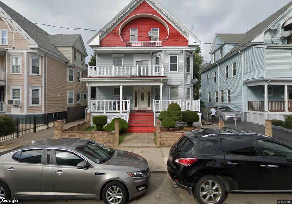
35 Johnston Rd Dorchester Center, MA 02124
Franklin Field South NeighborhoodEstimated Value: $783,000 - $1,154,000
6
Beds
2
Baths
3,748
Sq Ft
$251/Sq Ft
Est. Value
About This Home
This home is located at 35 Johnston Rd, Dorchester Center, MA 02124 and is currently estimated at $940,558, approximately $250 per square foot. 35 Johnston Rd is a home located in Suffolk County with nearby schools including KIPP Academy Boston Charter School and Berea Seventh-day Adventist Academy.
Ownership History
Date
Name
Owned For
Owner Type
Purchase Details
Closed on
May 31, 2001
Sold by
Thomas Altha
Bought by
Allen Crokoel
Current Estimated Value
Home Financials for this Owner
Home Financials are based on the most recent Mortgage that was taken out on this home.
Original Mortgage
$245,950
Interest Rate
7.09%
Mortgage Type
Purchase Money Mortgage
Create a Home Valuation Report for This Property
The Home Valuation Report is an in-depth analysis detailing your home's value as well as a comparison with similar homes in the area
Home Values in the Area
Average Home Value in this Area
Purchase History
| Date | Buyer | Sale Price | Title Company |
|---|---|---|---|
| Allen Crokoel | $258,900 | -- |
Source: Public Records
Mortgage History
| Date | Status | Borrower | Loan Amount |
|---|---|---|---|
| Open | Allen Crokoel | $285,000 | |
| Closed | Allen Crokoel | $255,500 | |
| Closed | Allen Crokoel | $245,950 | |
| Previous Owner | Allen Crokoel | $25,000 |
Source: Public Records
Tax History Compared to Growth
Tax History
| Year | Tax Paid | Tax Assessment Tax Assessment Total Assessment is a certain percentage of the fair market value that is determined by local assessors to be the total taxable value of land and additions on the property. | Land | Improvement |
|---|---|---|---|---|
| 2025 | $7,772 | $671,200 | $255,500 | $415,700 |
| 2024 | $6,372 | $584,600 | $220,300 | $364,300 |
| 2023 | $5,814 | $541,300 | $204,000 | $337,300 |
| 2022 | $5,354 | $492,100 | $185,400 | $306,700 |
| 2021 | $4,907 | $459,900 | $173,300 | $286,600 |
| 2020 | $4,646 | $440,000 | $165,800 | $274,200 |
| 2019 | $4,547 | $431,400 | $129,000 | $302,400 |
| 2018 | $4,108 | $392,000 | $129,000 | $263,000 |
| 2017 | $3,879 | $366,300 | $129,000 | $237,300 |
| 2016 | $3,766 | $342,400 | $129,000 | $213,400 |
| 2015 | $3,752 | $309,800 | $104,700 | $205,100 |
| 2014 | $3,263 | $259,400 | $104,700 | $154,700 |
Source: Public Records
Map
Nearby Homes
- 28 Hansborough St Unit 2
- 28 Hansborough St Unit 5
- 492 Harvard St
- 27 Havelock St
- 29 Havelock St
- 14 Fabyan St
- 21 Ashton St Unit 1
- 14 Estella St Unit 2
- 69 Lucerne St
- 17 Greendale Rd Unit 2F
- 44 Floyd St
- 57 Stratton St
- 23 Deering Rd
- 19 Deering Rd
- 6 Deering Rd
- 84 W Main St Unit 84
- 140 Callender St
- 1 Finch St
- 1 Finch St Unit 1
- 67 Wildwood St
- 35 Johnston Rd Unit 1
- 39 Johnston Rd
- 39 Johnston Rd Unit 3
- 31 Johnston Rd
- 43 Johnston Rd
- 27 Johnston Rd
- 32 Hansborough St
- 32 Hansborough St Unit 2
- 36 Hansborough St
- 40 Hansborough St
- 30 Johnston Rd
- 30 Johnston Rd Unit 2
- 30 Johnston Rd Unit 3
- 26 Johnston Rd Unit 1
- 26 Johnston Rd
- 26 Johnston Rd
- 34 Johnston Rd
- 47 Johnston Rd
- 23 Johnston Rd
- 24 Hansborough St Unit 2