Estimated Value: $324,000 - $471,000
4
Beds
3
Baths
2,145
Sq Ft
$172/Sq Ft
Est. Value
About This Home
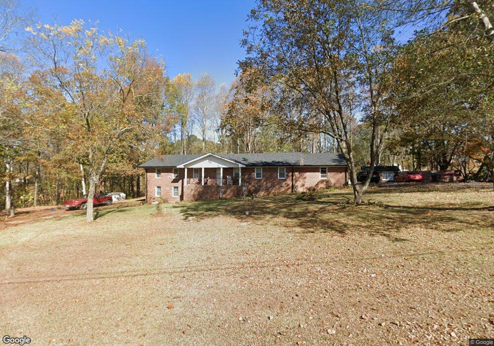
This home is located at 35 McBurnett St, Waco, GA 30182 and is currently estimated at $368,904, approximately $171 per square foot. 35 McBurnett St is a home located in Haralson County with nearby schools including Haralson County High School.
Ownership History
Date
Name
Owned For
Owner Type
Purchase Details
Closed on
Oct 2, 2020
Sold by
Harrison Timothy Dale
Bought by
Ostroski Sherri
Current Estimated Value
Home Financials for this Owner
Home Financials are based on the most recent Mortgage that was taken out on this home.
Original Mortgage
$208,550
Outstanding Balance
$185,494
Interest Rate
2.9%
Mortgage Type
New Conventional
Estimated Equity
$183,410
Purchase Details
Closed on
Feb 5, 2014
Sold by
Harrison Amy M
Bought by
Harrison Timothy D
Purchase Details
Closed on
Apr 27, 2006
Sold by
Waco Baptist Church
Bought by
Harrison Timothy Dale
Purchase Details
Closed on
Sep 19, 2003
Sold by
Rogers Kenneth E
Bought by
Waco Baptist Church Inc
Purchase Details
Closed on
Jul 9, 1980
Bought by
Waco Baptist Church
Create a Home Valuation Report for This Property
The Home Valuation Report is an in-depth analysis detailing your home's value as well as a comparison with similar homes in the area
Home Values in the Area
Average Home Value in this Area
Purchase History
| Date | Buyer | Sale Price | Title Company |
|---|---|---|---|
| Ostroski Sherri | $215,000 | -- | |
| Harrison Timothy D | -- | -- | |
| Harrison Timothy Dale | -- | -- | |
| Waco Baptist Church Inc | -- | -- | |
| Waco Baptist Church Inc | -- | -- | |
| Waco Baptist Church | -- | -- |
Source: Public Records
Mortgage History
| Date | Status | Borrower | Loan Amount |
|---|---|---|---|
| Open | Ostroski Sherri | $208,550 |
Source: Public Records
Tax History Compared to Growth
Tax History
| Year | Tax Paid | Tax Assessment Tax Assessment Total Assessment is a certain percentage of the fair market value that is determined by local assessors to be the total taxable value of land and additions on the property. | Land | Improvement |
|---|---|---|---|---|
| 2024 | $3,270 | $106,901 | $7,690 | $99,211 |
| 2023 | $3,469 | $109,203 | $7,608 | $101,595 |
| 2022 | $2,495 | $87,134 | $7,608 | $79,526 |
| 2021 | $2,492 | $83,128 | $7,608 | $75,520 |
| 2020 | $1,953 | $63,537 | $7,608 | $55,929 |
| 2019 | $1,976 | $62,351 | $7,608 | $54,743 |
| 2018 | $1,984 | $61,578 | $7,608 | $53,970 |
| 2017 | $1,853 | $55,048 | $7,608 | $47,440 |
| 2016 | $1,547 | $50,502 | $7,608 | $42,894 |
| 2015 | $1,536 | $50,090 | $7,608 | $42,483 |
| 2014 | $1,572 | $52,079 | $9,576 | $42,503 |
Source: Public Records
Map
Nearby Homes
- 145 Wall St
- 163 Atlantic Ave
- 67 Depot St
- 381 King St
- 586 Old Bushmill Rd
- 735 Tallapoosa St W
- 0 Stonebridge Blvd Unit 143588
- 0 Mt Zion St Unit 7399245
- 707 Mill Stone Way
- 101 Bush Creek Way
- 273 Sewell Rd
- 180 Five Notch Dr
- 6315 Highway 78
- 0 Nitra Rd Unit 9546245
- 522 Atlantic Ave
- 327 Crest Pointe S
- 321 Stonebridge Blvd
- 319 Stonebridge Blvd
- 305 Crest Pointe S
- 330 Kensington Cir
- 31 McBurnett St
- 149 Atlantic Ave
- 121 Wall St
- 135 Atlantic Ave
- 158 Wall St
- 158 Wall St
- 164 Atlantic Ave
- 121 Atlantic Ave
- 158 Atlantic Ave
- 176 Atlantic Ave
- 55 Commercial Ave
- 150 Atlantic Ave
- 154 Wall St
- 0 Wall St Unit 7218639
- 0 Wall St Unit 7018954
- 0 Wall St
- 188 Atlantic Ave
- 94 Wall St
- 138 Atlantic Ave
- 1 Mineral Springs Rd