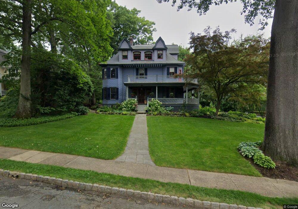
35 Oak Ridge Ave Summit, NJ 07901
Estimated Value: $2,356,636 - $3,747,000
--
Bed
--
Bath
3,799
Sq Ft
$758/Sq Ft
Est. Value
About This Home
This home is located at 35 Oak Ridge Ave, Summit, NJ 07901 and is currently estimated at $2,879,879, approximately $758 per square foot. 35 Oak Ridge Ave is a home located in Union County with nearby schools including L C Johnson Summit Middle School, Summit Sr High School, and Oak Knoll School of the Holy Child.
Ownership History
Date
Name
Owned For
Owner Type
Purchase Details
Closed on
May 26, 2009
Sold by
Cannon Kell S and Cannon Kimberly G
Bought by
Richter Brady and Richter Jennifer L
Current Estimated Value
Purchase Details
Closed on
Jun 22, 2001
Sold by
Thomas Jean R
Bought by
Cannon Kell S and Cannon Kimberly G
Home Financials for this Owner
Home Financials are based on the most recent Mortgage that was taken out on this home.
Original Mortgage
$485,000
Interest Rate
7.14%
Create a Home Valuation Report for This Property
The Home Valuation Report is an in-depth analysis detailing your home's value as well as a comparison with similar homes in the area
Home Values in the Area
Average Home Value in this Area
Purchase History
| Date | Buyer | Sale Price | Title Company |
|---|---|---|---|
| Richter Brady | $1,900,000 | Fidelity Natl Title Ins Co | |
| Cannon Kell S | $685,000 | Chicago Title Insurance Co |
Source: Public Records
Mortgage History
| Date | Status | Borrower | Loan Amount |
|---|---|---|---|
| Previous Owner | Cannon Kell S | $485,000 |
Source: Public Records
Tax History Compared to Growth
Tax History
| Year | Tax Paid | Tax Assessment Tax Assessment Total Assessment is a certain percentage of the fair market value that is determined by local assessors to be the total taxable value of land and additions on the property. | Land | Improvement |
|---|---|---|---|---|
| 2025 | $28,519 | $654,700 | $340,500 | $314,200 |
| 2024 | $28,329 | $654,700 | $340,500 | $314,200 |
| 2023 | $28,329 | $654,700 | $340,500 | $314,200 |
| 2022 | $28,041 | $654,700 | $340,500 | $314,200 |
| 2021 | $28,263 | $654,700 | $340,500 | $314,200 |
| 2020 | $28,545 | $654,700 | $340,500 | $314,200 |
| 2019 | $28,578 | $654,700 | $340,500 | $314,200 |
| 2018 | $28,394 | $654,700 | $340,500 | $314,200 |
| 2017 | $28,578 | $654,700 | $340,500 | $314,200 |
| 2016 | $28,159 | $654,700 | $340,500 | $314,200 |
| 2015 | $27,609 | $654,700 | $340,500 | $314,200 |
| 2014 | $26,895 | $654,700 | $340,500 | $314,200 |
Source: Public Records
Map
Nearby Homes
- 7 Valemont Way
- 10 Rowan Rd
- 2 Glen Ave
- 16 Beauvoir Ave
- 34 Ashland Rd
- 10 Henry St
- 109 Mountain Ave
- 49 Oakland Place
- 67 Tulip St
- 1 Irving Place
- 103 Park Ave Unit E206
- 103 Park Ave Unit E201
- 32 Locust Dr
- 10 Waldron Ave
- 133 Summit Ave Unit 10
- 50 Parmley Place Unit 203
- 149 Ashland Rd
- 160 Springfield Ave
- 23 Euclid Ave
- 28 Morris Ave Unit G4
- 29 Oak Ridge Ave
- 39 Oak Ridge Ave
- 27 Oak Ridge Ave
- 49 Rowan Rd
- 30 Mountain Ave
- 32 Mountain Ave
- 43 Oak Ridge Ave
- 36 Mountain Ave Unit 2
- 36 Mountain Ave
- 50 Rowan Rd
- 26 Mountain Ave
- 25 Oak Ridge Ave
- 42 Oak Ridge Ave
- 38 Mountain Ave
- 45 Rowan Rd
- 24 Mountain Ave
- 28 Oak Ridge Ave
- 45 Oak Ridge Ave
- 44 Oak Ridge Ave
- 22 Mountain Ave