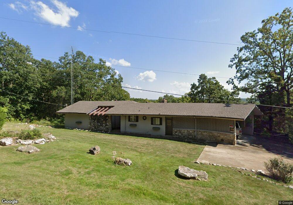
35 Okmulgee Dr Cherokee Village, AR 72529
Estimated Value: $169,753 - $373,000
--
Bed
3
Baths
1,450
Sq Ft
$158/Sq Ft
Est. Value
About This Home
This home is located at 35 Okmulgee Dr, Cherokee Village, AR 72529 and is currently estimated at $229,688, approximately $158 per square foot. 35 Okmulgee Dr is a home located in Sharp County with nearby schools including Cherokee Elementary School, Highland Middle School, and Highland High School.
Ownership History
Date
Name
Owned For
Owner Type
Purchase Details
Closed on
Jun 12, 2015
Sold by
Parr Donald A and Parr Susan J
Bought by
Parr Donald A and Parr Susan J
Current Estimated Value
Purchase Details
Closed on
Jun 27, 2008
Sold by
Parr Dennis E
Bought by
The Sand Living Trust
Home Financials for this Owner
Home Financials are based on the most recent Mortgage that was taken out on this home.
Original Mortgage
$15,000
Outstanding Balance
$9,643
Interest Rate
6%
Mortgage Type
Seller Take Back
Estimated Equity
$220,045
Create a Home Valuation Report for This Property
The Home Valuation Report is an in-depth analysis detailing your home's value as well as a comparison with similar homes in the area
Home Values in the Area
Average Home Value in this Area
Purchase History
| Date | Buyer | Sale Price | Title Company |
|---|---|---|---|
| Parr Donald A | -- | None Available | |
| The Sand Living Trust | $15,000 | None Available | |
| Parr Dennis E | $85,000 | None Available |
Source: Public Records
Mortgage History
| Date | Status | Borrower | Loan Amount |
|---|---|---|---|
| Open | The Sand Living Trust | $15,000 |
Source: Public Records
Tax History Compared to Growth
Tax History
| Year | Tax Paid | Tax Assessment Tax Assessment Total Assessment is a certain percentage of the fair market value that is determined by local assessors to be the total taxable value of land and additions on the property. | Land | Improvement |
|---|---|---|---|---|
| 2024 | $823 | $25,710 | $700 | $25,010 |
| 2023 | $755 | $25,710 | $700 | $25,010 |
| 2022 | $776 | $16,790 | $500 | $16,290 |
| 2021 | $776 | $16,790 | $500 | $16,290 |
| 2020 | $1,019 | $16,790 | $500 | $16,290 |
| 2019 | $974 | $15,680 | $500 | $15,180 |
| 2018 | $974 | $15,680 | $500 | $15,180 |
| 2017 | $593 | $15,680 | $500 | $15,180 |
| 2016 | $768 | $15,680 | $500 | $15,180 |
| 2015 | -- | $15,680 | $500 | $15,180 |
| 2014 | -- | $19,240 | $500 | $18,740 |
| 2013 | -- | $19,240 | $500 | $18,740 |
Source: Public Records
Map
Nearby Homes
- L37B12 N Lakeshore Dr
- 28 N Lakeshore Dr
- L-25 B-7 Navajo Trace
- 0 Tonto Dr Unit 25033260
- 0 Tonto Dr Unit 25004911
- 37 Los Indios Dr
- 29 Tonto Dr
- L-24 B-6 Navajo Trace
- 36 Winnebago Cir
- 114 Cherokee Rd
- 10 Winnebago Cir
- 7 Annette Rd
- 20 Tenkiller Ln
- 57 Iowa Dr
- 47 Iowa Dr
- 8 Annette Rd
- 12 Annette Rd
- 6 Annette Rd
- 16 Annette Rd
- 15 Setting Sun Trace
- 1 N Yurok Dr
- 2 Chickasha Dr
- 402 Chicksha Dr
- 9 N Lakeshore Dr
- 21 N Lakeshore Dr
- 403 Chickasha Dr
- 401 Chickasha Dr
- 22 N Lakeshore Dr
- 302 Chickasha Dr
- 22 N Lakeshore Dr
- 20 N Lakeshore Dr
- 202 S 10TH N Lakeshore Dr
- 26 N Lakeshore Dr
- 19 Okmulgee Dr
- 26 N Lakeshore Dr
- 18 N Lakeshore Dr
- 36 Okmulgee Dr
- N Lakeshore Dr
- 1001 N Lakeshore Dr
- 0 N Lakeshore Dr Unit 10114879