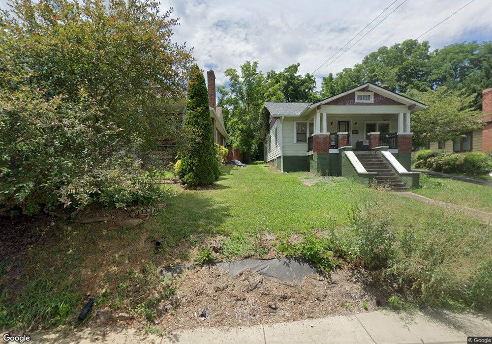
35 Ormond Ave Asheville, NC 28806
West Asheville NeighborhoodEstimated Value: $387,779 - $472,000
3
Beds
2
Baths
1,260
Sq Ft
$334/Sq Ft
Est. Value
About This Home
This home is located at 35 Ormond Ave, Asheville, NC 28806 and is currently estimated at $421,195, approximately $334 per square foot. 35 Ormond Ave is a home located in Buncombe County with nearby schools including Hall Fletcher Elementary, Isaac Dickson Elementary, and Ira B Jones Elementary.
Ownership History
Date
Name
Owned For
Owner Type
Purchase Details
Closed on
Jun 27, 2023
Sold by
Doyle Diane
Bought by
Roman Ronald M and Doyle Diane
Current Estimated Value
Purchase Details
Closed on
Sep 20, 2002
Sold by
Chappell Carol N
Bought by
Doyle Diane
Home Financials for this Owner
Home Financials are based on the most recent Mortgage that was taken out on this home.
Original Mortgage
$103,900
Interest Rate
6.3%
Create a Home Valuation Report for This Property
The Home Valuation Report is an in-depth analysis detailing your home's value as well as a comparison with similar homes in the area
Home Values in the Area
Average Home Value in this Area
Purchase History
| Date | Buyer | Sale Price | Title Company |
|---|---|---|---|
| Roman Ronald M | -- | None Listed On Document | |
| Roman Ronald M | -- | None Listed On Document | |
| Doyle Diane | $130,000 | -- |
Source: Public Records
Mortgage History
| Date | Status | Borrower | Loan Amount |
|---|---|---|---|
| Previous Owner | Doyle Diane | $103,900 | |
| Closed | Doyle Diane | $12,994 |
Source: Public Records
Tax History Compared to Growth
Tax History
| Year | Tax Paid | Tax Assessment Tax Assessment Total Assessment is a certain percentage of the fair market value that is determined by local assessors to be the total taxable value of land and additions on the property. | Land | Improvement |
|---|---|---|---|---|
| 2025 | -- | $179,900 | $80,400 | $99,500 |
| 2024 | -- | $179,900 | $80,400 | $99,500 |
| 2023 | $1,812 | $179,900 | $80,400 | $99,500 |
| 2022 | $1,794 | $179,900 | $0 | $0 |
| 2021 | $1,794 | $179,900 | $0 | $0 |
| 2020 | $1,636 | $151,800 | $0 | $0 |
| 2019 | $1,636 | $151,800 | $0 | $0 |
| 2018 | $1,636 | $151,800 | $0 | $0 |
| 2017 | $1,651 | $151,800 | $0 | $0 |
| 2016 | $1,866 | $151,800 | $0 | $0 |
| 2015 | $1,866 | $151,800 | $0 | $0 |
| 2014 | $1,843 | $151,800 | $0 | $0 |
Source: Public Records
Map
Nearby Homes
- 27 Ormond Ave
- 1389 Patton Ave
- 30 Dartmouth St
- 28 Deaverview Rd
- 50 Green Hill Ave
- 33 Wilshire Dr
- 99999 Haywood Rd
- 155 Sulphur Springs Rd
- 42 Mayday St
- 20 Rash Rd
- 110 Providence Rd
- 23 Laurel Loop
- 51 Baker Dr
- 78 Middlemont Ave
- 32 Harnett St
- 7 Bolton St Unit 4
- 9 Bolton St Unit 5
- 11 Bolton St Unit 6
- 20 Cloyes St
- 85 Carrier St
- 31 Ormond Ave
- 39 Ormond Ave
- 43 Ormond Ave
- 23 Ormond Ave
- 47 Ormond Ave
- .21 ACRE Ormond Ave Unit 35
- 32 Ormond Ave
- 26 Ormond Ave
- 49 Ormond Ave
- TBD Ormond Ave
- 40 Ormond Ave
- 24 Ormond Ave
- 44 Ormond Ave
- 44 Ormond Ave Unit 35
- 1408 Patton Ave
- 1408 Patton Ave Unit Suite B
- 48 Ormond Ave
- 1378 Patton Ave
- 52 Ormond Ave
- 56 Ormond Ave