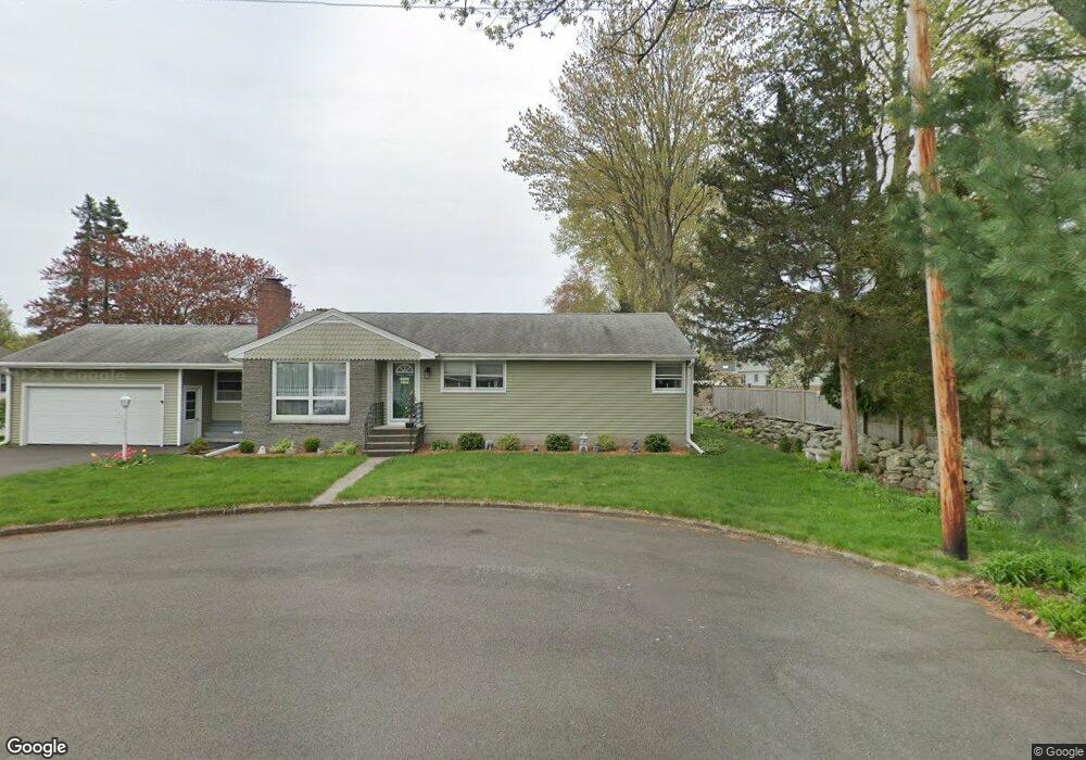
35 Paugassit Dr Stratford, CT 06614
Estimated Value: $455,000 - $527,000
3
Beds
3
Baths
1,276
Sq Ft
$389/Sq Ft
Est. Value
About This Home
This home is located at 35 Paugassit Dr, Stratford, CT 06614 and is currently estimated at $496,179, approximately $388 per square foot. 35 Paugassit Dr is a home located in Fairfield County with nearby schools including Eli Whitney Elementary School, Harry B. Flood Middle School, and Bunnell High School.
Ownership History
Date
Name
Owned For
Owner Type
Purchase Details
Closed on
Jun 5, 1998
Sold by
Stocklein Ernst and Stocklein Judith
Bought by
Makowicki David R and Makowicki Sally Z
Current Estimated Value
Home Financials for this Owner
Home Financials are based on the most recent Mortgage that was taken out on this home.
Original Mortgage
$146,000
Outstanding Balance
$28,145
Interest Rate
6.63%
Mortgage Type
Unknown
Estimated Equity
$468,034
Create a Home Valuation Report for This Property
The Home Valuation Report is an in-depth analysis detailing your home's value as well as a comparison with similar homes in the area
Home Values in the Area
Average Home Value in this Area
Purchase History
| Date | Buyer | Sale Price | Title Company |
|---|---|---|---|
| Makowicki David R | $183,000 | -- |
Source: Public Records
Mortgage History
| Date | Status | Borrower | Loan Amount |
|---|---|---|---|
| Open | Makowicki David R | $146,000 | |
| Previous Owner | Makowicki David R | $26,900 |
Source: Public Records
Tax History Compared to Growth
Tax History
| Year | Tax Paid | Tax Assessment Tax Assessment Total Assessment is a certain percentage of the fair market value that is determined by local assessors to be the total taxable value of land and additions on the property. | Land | Improvement |
|---|---|---|---|---|
| 2025 | $7,316 | $182,000 | $95,620 | $86,380 |
| 2024 | $7,316 | $182,000 | $95,620 | $86,380 |
| 2023 | $7,316 | $182,000 | $95,620 | $86,380 |
| 2022 | $7,182 | $182,000 | $95,620 | $86,380 |
| 2021 | $7,184 | $182,000 | $95,620 | $86,380 |
| 2020 | $7,214 | $182,000 | $95,620 | $86,380 |
| 2019 | $7,069 | $177,310 | $84,630 | $92,680 |
| 2018 | $7,075 | $177,310 | $84,630 | $92,680 |
| 2017 | $7,087 | $177,310 | $84,630 | $92,680 |
| 2016 | $6,913 | $177,310 | $84,630 | $92,680 |
| 2015 | $6,557 | $177,310 | $84,630 | $92,680 |
| 2014 | $6,702 | $188,090 | $91,420 | $96,670 |
Source: Public Records
Map
Nearby Homes
- 135 Wigwam Ln
- 80 Wilbrook Rd
- 735 Chickadee Ln
- 30 Bulmer Dr
- 1250 Huntington Rd
- 80 Sheffield Cir
- 1053 Cutspring Rd
- 246 Delaware Dr
- 175 Post Oak Rd
- 165 Douglas St
- 15 Tavern Rock Rd
- 160 Cheshire St
- 145 Dahl Ave
- 700 Huntington Rd
- 244 Rockland Ave
- 75 Tucci Dr
- 290 Hollywood Ave
- 52 Circle Dr
- 410 Seabreeze Dr
- 216 Ridge Rd
- 130 Pootatuck Path
- 300 Flagler Ave
- 125 Okenuck Trail
- 145 Okenuck Trail
- 320 Flagler Ave
- 280 Flagler Ave
- 30 Paugassit Dr
- 95 Okenuck Trail
- 120 Okenuck Trail
- 115 Pootatuck Path
- 340 Flagler Ave
- 260 Flagler Ave
- 135 Pootatuck Path
- 310 Flagler Ave
- 140 Okenuck Trail
- 75 Okenuck Trail
- 100 Okenuck Trail
- 25 Pequot Ave
- 270 Flagler Ave
- 360 Flagler Ave