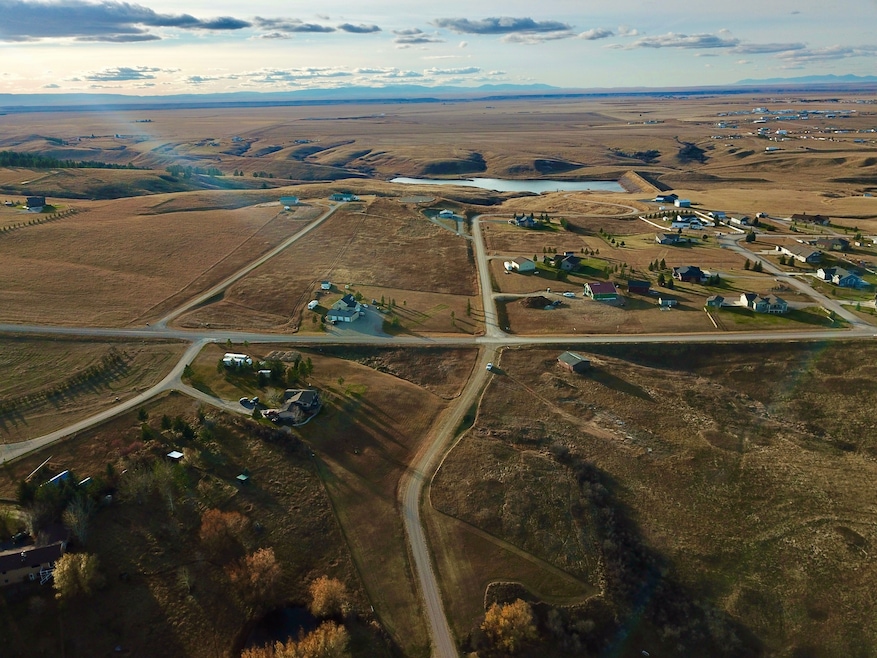
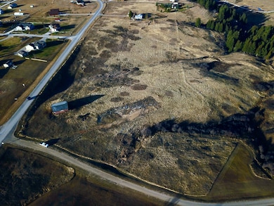
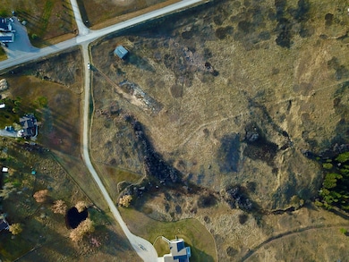
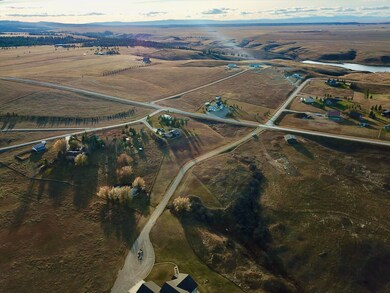
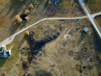
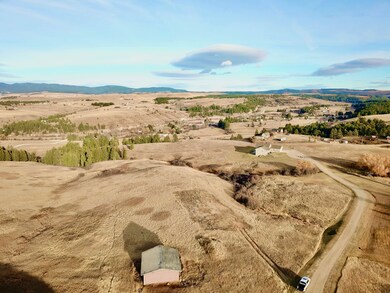
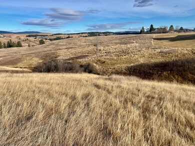
Nestled just two miles south of Lewistown and in the very heart of Montana, this 4.346-acre parcel offers an exceptional opportunity to build a forever home. With paved year-round access, power nearby, and a setting framed by the majestic Judith Mountains, this property captures the essence of upscale rural living—peace, privacy, and panoramic views. The land’s gently sloping terrain provides multiple prime building sites, ideal for a custom home designed to take in the sweeping mountain vistas. Across the road and down the lane mere minutes, the tranquil waters of Big Casino Creek Reservoir invite you to enjoy year-round fishing, kayaking, and quiet reflection, while nearby Snowy and Little Belt Mountains offer unmatched opportunities for recreation—hiking, horseback riding, skiing, and hunting in some of Montana’s most scenic terrain. Love mountains scenery and adventuring? This area is surrounded by 5 different mountain ranges so point your compass in any direction for an unforgettable experience! Without the restrictions of an HOA and guided only by minimal covenants, owners enjoy the freedom to craft a residence or retreat that complements the landscape while preserving the area’s enduring charm and quality. Just minutes away, Lewistown stands as one of Montana’s most inviting communities—an authentic small town with modern amenities, boutique shops, fine dining, medical facilities, and a regional airport. Don’t let an opportunity like this one pass you by!
Local Area
Lewistown, Montana is a centrally located town in Fergus County and enchants with its authentic community and proximity to five mountain ranges: the Snowies, the Judiths, the Moccasins, the Belts, and the Highwoods. These ranges encompass Lewistown and supply many recreational activities to locals and tourists traveling through. The town is clean, and streets are tree-lined and maintained along with many well-preserved historic businesses and homes. Although it is predominately an agricultural community, it is a premier destination for fishing, hiking, hunting, and biking. This area does not lack in things to do. Camping, fishing, hiking, and boating are available at Ackley Lake. Hunt for big game or hunt for fossils at Judith Peak in the Judith Mountains! Picnic and swim at the world’s largest natural warm spring with 50,000 gallons of water rising from the earth every minute of every day. Experience an authentic train ride and eat delicious entrees on the Charlie Russell Chew Choo Dinner Train. Venture out to camp, canoe, and hike at Crystal Lake. Hike the rugged trail up to the ice caverns and be part of an elite crowd that has accomplished it! See what life was like back in the mining times at the Gilt Edge, Kendall, and Maiden Ghost towns. Listen for the spine-tingling sound of elk bugling and watch the bull guard his cows at the Slippery Ann Elk viewing area.
Area Attractions
East Fork Reservoir
Located 11 miles southeast of Lewistown, the East Fork Reservoir offers fishing, winter ice fishing, no wake boating, canoeing, camping, biking, hiking, wildlife viewing, and general wildlife viewing. The reservoir is fished mostly for Northern Pike and Perch. This is a great spot for family recreating or a day adventure in beautiful central Montana.
Big Spring Creek
Big Spring Creek has a reputation with Lewistown locals as the nearest and finest fishing spot as it runs through and under the city. It is hard to keep this creek a secret and people that have learned of it travel from all over the state for year-round blue-ribbon fly fishing. Big Spring Creek emerges from the northern slopes of the Snowy Mountains, flows for almost 30 miles, and pumps from 50,000 to 64,000 gallons of 52-degree water that is enriched with minerals per minute! Thousands of Brown, Rainbow, and Cutthroat Trout are raised in these waters as they serve as a state hatchery. In addition to supplying Lewistown residents with its waters, the crystal-clear mineral waters are bottled and shipped throughout the country! There are six public access sites and other recreational activities include kayaking, swimming, and tubing. The city trail system of over 25 miles of trail meanders alongside the creek so you can exercise while taking in the sights.
Slippery Ann Elk Viewing Area
Watch a large number of elk congregate during rut or breeding season. Nearly 500 elk may visit this area in September and attract those seeking to hear that spine-tingling bull elk bugle.
Charles M Russell National Wildlife Refuge
The CMR National Wildlife Refuge displays badlands, cottonwood river bottoms, forested coulees, and sprawling prairies. The Refuge provides over one million acres of public land for fishing, hiking, hunting, camping, bird-watching, and other outdoor activities. The area spans about 125 miles along the Missouri River, from the Fort Peck Dam west to the boundary with the Upper Missouri River Breaks National Monument. If you’re looking to observe game in its natural habitat, this refuge shall reward you. It is the second-largest refuge in the continental US. In September and October locals and tourists from all over gather to watch the bull elk bugle and battle for the cow’s attention at Slippery Ann Wildlife Viewing Area. Miles of parked cars can be seen while people sit on lawn chairs and watch for hours the wild display the elk present. Herds of deer, red foxes, and coyotes can also be observed. Bird watchers can delight in spying on mountain bluebirds and black-capped chickadees. Osprey, spotted sandpipers, and white pelicans can be found along the coast of the reservoir.
Hunting
Renowned for its hunting, Montana provides the habitat. The Missouri River Breaks of the Fort Peck Area are no different. Elk and mule deer like to gather near the ridges of Fort Peck Lake, some quite large. White-tailed deer and pronghorn can be found as well. Big Horn Sheep can be harvested in the area. Whether it’s big game, waterfowl, predators like coyotes, or upland game birds, this area boasts some of the best in the state.
Ackley Lake State Park
Nestled in the heart of Montana, Ackley Lake State Park offers 290 acres of park that includes mountain views and Ackley Lake. The lake provides fishing, boating, swimming, birdwatching, picnicking, and camping. It is stocked with Rainbow Trout and Tiger Muskie. The state park has camping sites and two boat launches. The lake is often good angling for 10-to-15-inch fish.
Judith River
The Judith River is a tributary of the majestic Missouri River. Flowing for 127 miles, the river begins in the Little Belt Mountains where it eventually pours into the Missouri near Judith Landing. This area is identified for its white cliffs and spectacular rock formations as well as its floating opportunities. Fish for Brook, Brown, and Rainbow Trout, Burbot, Channel Catfish, Mountain Whitefish, and Sauger.