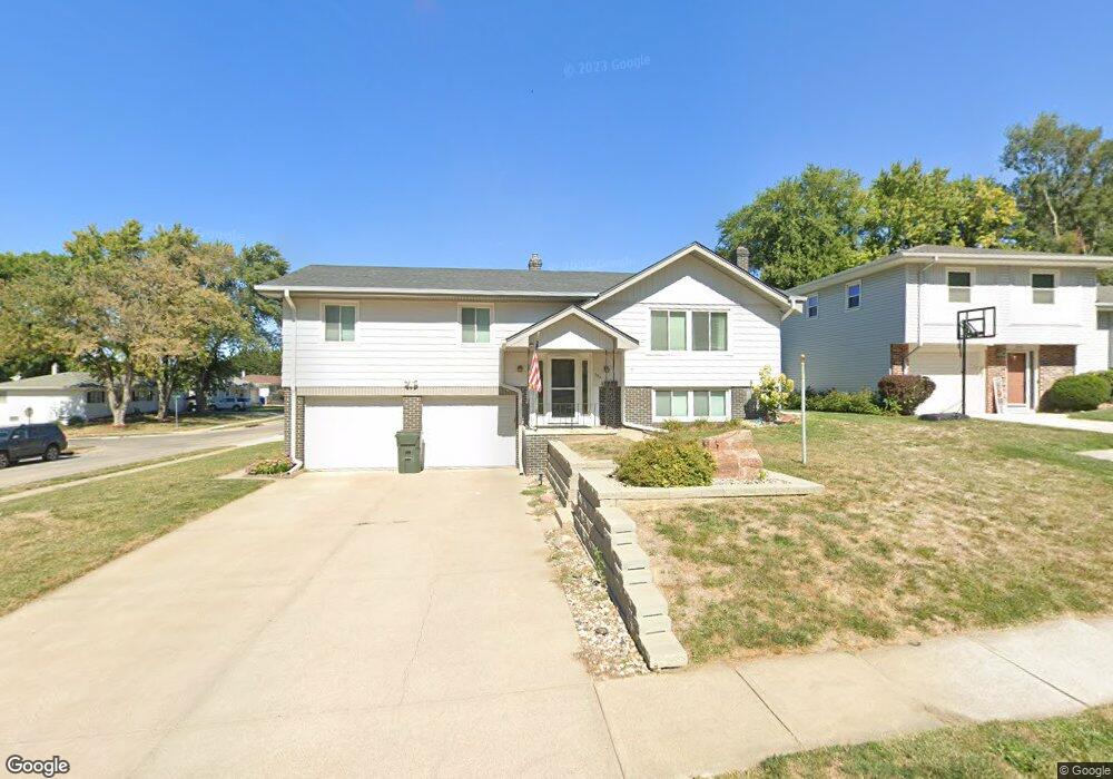
350 Michael Dr Gretna, NE 68028
Estimated Value: $256,000 - $282,000
3
Beds
1
Bath
1,248
Sq Ft
$216/Sq Ft
Est. Value
About This Home
This home is located at 350 Michael Dr, Gretna, NE 68028 and is currently estimated at $270,086, approximately $216 per square foot. 350 Michael Dr is a home located in Sarpy County with nearby schools including Gretna Elementary School, Gretna Middle School, and Gretna High School.
Ownership History
Date
Name
Owned For
Owner Type
Purchase Details
Closed on
Jan 24, 2020
Sold by
Wade Carol L and Nelsen Carol
Bought by
Nelsen Mark and Nelsen Carol
Current Estimated Value
Home Financials for this Owner
Home Financials are based on the most recent Mortgage that was taken out on this home.
Original Mortgage
$117,000
Interest Rate
3.7%
Mortgage Type
New Conventional
Purchase Details
Closed on
Mar 11, 2009
Sold by
Wade Donald L
Bought by
Wade Carol L
Create a Home Valuation Report for This Property
The Home Valuation Report is an in-depth analysis detailing your home's value as well as a comparison with similar homes in the area
Home Values in the Area
Average Home Value in this Area
Purchase History
We collect this data history from publicly available records. To have your information removed, we recommend requesting removal directly through your county’s website.
| Date | Buyer | Sale Price | Title Company |
|---|---|---|---|
| Nelsen Mark | -- | None Available | |
| Wade Carol L | -- | None Available |
Source: Public Records
Mortgage History
We collect this data history from publicly available records. To have your information removed, we recommend requesting removal directly through your county’s website.
| Date | Status | Borrower | Loan Amount |
|---|---|---|---|
| Closed | Nelsen Mark | $117,000 |
Source: Public Records
Tax History
| Year | Tax Paid | Tax Assessment Tax Assessment Total Assessment is a certain percentage of the fair market value that is determined by local assessors to be the total taxable value of land and additions on the property. | Land | Improvement |
|---|---|---|---|---|
| 2025 | $4,582 | $272,448 | $36,000 | $236,448 |
| 2024 | $4,410 | $252,285 | $33,000 | $219,285 |
| 2023 | $4,410 | $205,161 | $28,000 | $177,161 |
| 2022 | $4,649 | $203,742 | $26,000 | $177,742 |
| 2021 | $3,845 | $170,412 | $26,000 | $144,412 |
| 2020 | $3,523 | $157,043 | $26,000 | $131,043 |
| 2019 | $3,351 | $149,560 | $26,000 | $123,560 |
| 2018 | $3,169 | $142,089 | $19,000 | $123,089 |
| 2017 | $3,022 | $135,322 | $19,000 | $116,322 |
| 2016 | $2,827 | $126,933 | $19,000 | $107,933 |
| 2015 | $2,710 | $122,699 | $19,000 | $103,699 |
| 2014 | $2,624 | $119,789 | $19,000 | $100,789 |
| 2012 | -- | $117,498 | $19,000 | $98,498 |
Source: Public Records
Map
Nearby Homes
- Lot 111 W Gruenther Rd
- Lot 127 W Gruenther Rd
- TBD Lot 64 W Gruenther Rd
- 516 W Angus St
- Lot 80 W Gruenther Rd
- Lot 71 W Gruenther Rd
- TBD Lot 63 W Gruenther Rd
- 21211 Mcclellan Dr
- 108 Meadow Ln
- 21417 Parkview Dr
- 21730 Parkview Dr
- 21821 Parkview Dr
- 21603 Parkview Dr
- 21726 Parkview Dr
- 21725 Parkview Dr
- 21710 Parkview Dr
- 21119 Schofield Dr
- 21719 Amber Dr
- 21715 Amber Dr
- 20911 Hampton Cir
- 346 Michael Dr
- 347 W Glenmore Dr
- 342 Michael Dr
- 343 W Glenmore Dr
- 518 Pawnee Dr
- 516 Pawnee Dr
- 349 Michael Dr
- 339 W Glenmore Dr
- 338 Michael Dr
- 514 Pawnee Dr
- 610 Pawnee Dr
- 343 Michael Dr
- 335 W Glenmore Dr
- 512 Pawnee Dr
- 334 Michael Dr
- 401 Michael Dr
- 612 Pawnee Dr
- 339 Michael Dr
- 510 Pawnee Dr
- 405 Michael Dr
Your Personal Tour Guide
Ask me questions while you tour the home.