


3501 Raptor Ridge Ln Laporte, CO 80535
Estimated payment $4,317/month
About This Lot
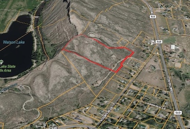
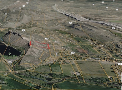
Rare, ready-to-build 16-acre parcel with east-facing slope and sweeping city and foothills views. Located on a private 2-property road, fully approved via Minor Land Division for immediate building. Overlooking Laporte ,Bellvue and just above Watson Lake with quick access to Fort Collins, this property offers unmatched privacy, serenity, and foothills lifestyle opportunity.Views are the main part of what you get with this one of a kind Raptor Ridge property. At 15.94 acres, this property is bisected by elevation line 5280. The terrain slopes from west to east and has dryland, mountain growth. You can look out over the western part of the property and directly down into Watson Lake and the Cache la Poudre River. The land is private yet accessible, with enough space for animals, gardens, or outdoor recreation. Rock outcroppings and natural vegetation add to the character, giving it that quintessential Colorado feel, wild and serene, but close to town conveniences. Beyond the immediate beauty of the land, 3501 Raptor Ridge places residents at the heart of Northern Colorado's outdoor lifestyle. The Cache la Poudre River, Colorado's only designated Wild and Scenic River, lies just minutes away, offering world-class fly fishing, kayaking, and whitewater rafting. Horsetooth Reservoir provides boating, paddleboarding, and rock climbing along its dramatic hogbacks, while nearby trail systems-including Lory State Park, Arthur's Rock, Bobcat Ridge, and Fort Collins' foothills open space-offer endless opportunities for hiking and biking. Wildlife is abundant, from deer and elk to soaring hawks and eagles, and winter sports are accessible both locally and in the high-country resorts of Eldora, Winter Park, and Steamboat Springs. For those seeking quiet, Red Feather Lakes and Roosevelt National Forest provide scenic fishing, camping, and backcountry exploration. Life at Raptor Ridge blends the serenity of Colorado's natural beauty with easy access to year-round adventure. There is a shared well with the other property in this Land Division or the West Fort Collins Water District has confirmed that a tap is available. No mineral rights are included with this property. The Laporte and Bellvue area combines small-town charm with open landscapes, a balance increasingly rare as development becomes more restricted. Country lanes wind past historic homesteads, vineyards, and farmland, yet Fort Collins' amenities-including shopping, dining, and cultural events-are only minutes away. Bellvue contributes a rustic community vibe, with a general store, local gatherings, and a proud connection to the region's heritage. Northern Colorado's climate further enhances the area's appeal, with over 300 days of sunshine annually. Summers bring warm, dry days and cool evenings, while winters are generally mild in the valleys with light snowfalls and sunny breaks. Spring awakens wildflowers and green pastures, and autumn transforms the hillsides into golden and red hues. Average annual precipitation is moderate, sustaining lush meadows and river corridors without long gray stretches, creating a climate ideal for year-round living and outdoor enjoyment. The Laporte and Bellvue region is steeped in history, providing a rich backdrop for life at 3501 Raptor Ridge. Laporte, meaning "the door" in French, was established in the mid-1800s as a trading post and gateway for trappers, traders, and pioneers along the Overland Trail. It served as the first county seat of Larimer County, while Bellvue grew as a farming and quarrying community whose stone contributed to historic buildings in Fort Collins and Denver. The Cache la Poudre River supported both Native American tribes and early settlers, shaping the patterns of settlement and agriculture that still influence the valley today. The iconic Mishawaka Amphitheatre has long been a cultural landmark along the river, hosting music, art, and community gatherings for generations. Beyond formal history, the region offers a slower, rural lifestyle that emphasizes community, open space, and connection to the land-qualities increasingly rare as parcels under 35 acres are tightly restricted. Local traditions, from seasonal festivals to small-town markets and gatherings, continue to give Laporte and Bellvue a distinctive character. Historic homesteads, century-old irrigation ditches, and red sandstone structures provide a tangible link to the past, while the surrounding foothills and river corridors preserve the natural setting that has drawn residents for generations. 3501 Raptor Ridge allows future homeowners to step into this story while creating their own chapter, blending the heritage of Northern Colorado with modern living, open landscapes, and the rare opportunity to build on one of the county's few pre-approved parcels under 35 acres.
Property Details
Property Type
- Land
Lot Details
- 15.94 Acre Lot
Map
Home Values in the Area
Average Home Value in this Area
Property History
We collect this data history from publicly available records. To have your information removed, we recommend requesting removal directly through your county’s website.
| Date | Event | Price | List to Sale | Price per Sq Ft |
|---|---|---|---|---|
| 09/24/2025 09/24/25 | For Sale | $675,000 | -- | -- |
Source: NY State MLS
MLS Number: 11584341
APN: 98302-06-702
Disclaimer: Certain information contained herein is derived from information provided by parties other than Homes.com. All information provided is deemed reliable, but is not guaranteed to be accurate and should be independently verified.
![]() IDX information is provided exclusively for personal, non-commercial use, and may not be used for any purpose other than to identify prospective properties consumers may be interested in purchasing. Information is deemed reliable but not guaranteed.
IDX information is provided exclusively for personal, non-commercial use, and may not be used for any purpose other than to identify prospective properties consumers may be interested in purchasing. Information is deemed reliable but not guaranteed.
- 4520 W County Road 54g
- 0 Arapaho Valley Rd Unit Lot 3
- 0 Arapaho Valley Rd Unit Lot 15
- 0 Arapaho Valley Rd Unit Lot 54
- 0 Arapaho Valley Rd Unit Lot 16
- 0 Arapaho Valley Rd Unit Lot 53
- 4442 Del Colina Way
- 3309 Buckskin Trail
- 3704 Buckskin Trail
- 4013 Cork Dr
- 2912 Lochlomond Dr
- 3328 Mcconnell Dr
- 4318 Green Mile Dr
- 4753 Dr
- 4516 Bingham Hill Rd
- 4721 Arthur Mae Ln
- 3421 Vernon Dr
- 3201 W County Road 54g Unit F4
- 4727 Arthur Mae Ln
- 6109 US Highway 287
- 3512 Post Rd
- 417 N Hollywood St Unit 2
- 1020 N Taft Hill Rd
- 630 N Taft Hill Rd
- 2543 Laporte Ave
- 616 N Frey Ave
- 155 Briarwood Rd
- 524 N Frey Ave Unit B
- 527 N Bryan Ave Unit 1
- 508 Louise Ln
- 725 Aztec Dr Unit Aztec725C (KC-AM)-1
- 1850 Laporte Ave Unit C21
- 1850 Laporte Ave Unit A5
- 1850 Laporte Ave Unit A6
- 1850 Laporte Ave Unit D38
- 1434 Wood Ln
- 2500 W Mulberry St
- 308 Briarwood Rd
- 205 S Taft Hill Rd
- 1201 Pomona St Unit C

Ask me questions while you tour the home.