Estimated Value: $254,000 - $351,000
--
Bed
2
Baths
1,092
Sq Ft
$289/Sq Ft
Est. Value
About This Home
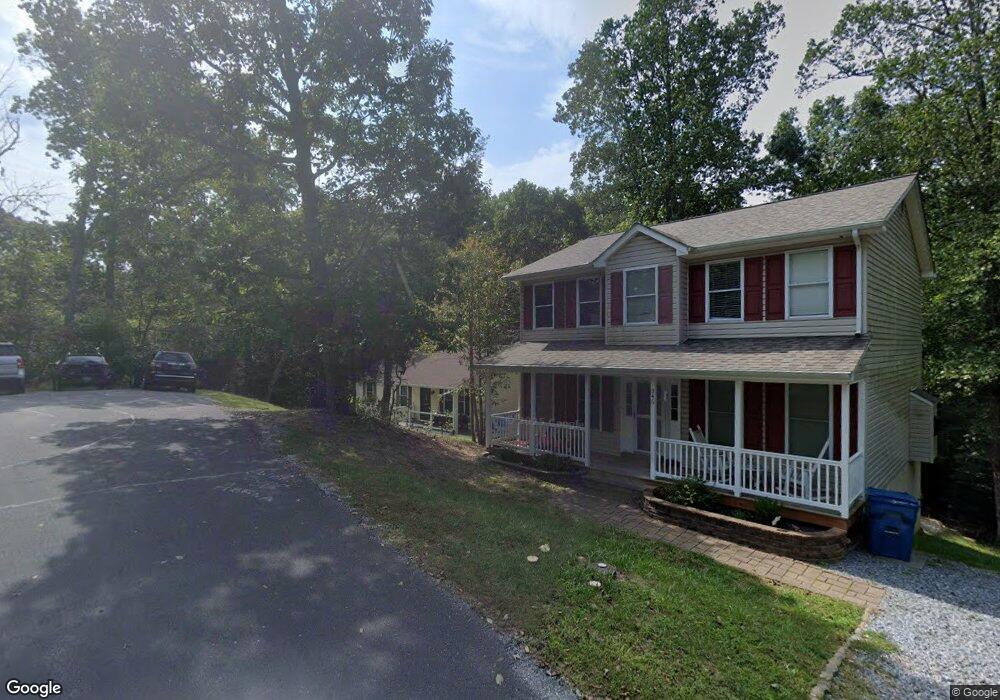
This home is located at 351 Chippewa Ln, Lusby, MD 20657 and is currently estimated at $316,037, approximately $289 per square foot. 351 Chippewa Ln is a home located in Calvert County with nearby schools including Patuxent Appeal Elementary Campus, Mill Creek Middle School, and Patuxent High School.
Ownership History
Date
Name
Owned For
Owner Type
Purchase Details
Closed on
Sep 18, 2001
Sold by
Secretary Of Veterans Affairs
Bought by
Sypa John A and Sypa Renee M
Current Estimated Value
Purchase Details
Closed on
Aug 24, 2001
Sold by
Hill Kevin Dale and Hill Teresa D
Bought by
Secretary Of Veterans Affairs
Purchase Details
Closed on
Jun 25, 1996
Sold by
Winston Corp
Bought by
Hill Kevin Dale and Hill Teresa D
Purchase Details
Closed on
Nov 23, 1993
Sold by
Mcfaden J C
Bought by
Winston Corp
Home Financials for this Owner
Home Financials are based on the most recent Mortgage that was taken out on this home.
Original Mortgage
$300,000
Interest Rate
6.77%
Create a Home Valuation Report for This Property
The Home Valuation Report is an in-depth analysis detailing your home's value as well as a comparison with similar homes in the area
Home Values in the Area
Average Home Value in this Area
Purchase History
| Date | Buyer | Sale Price | Title Company |
|---|---|---|---|
| Sypa John A | $111,000 | -- | |
| Secretary Of Veterans Affairs | $97,825 | -- | |
| Hill Kevin Dale | $104,950 | -- | |
| Winston Corp | $7,500 | -- |
Source: Public Records
Mortgage History
| Date | Status | Borrower | Loan Amount |
|---|---|---|---|
| Previous Owner | Winston Corp | $300,000 | |
| Closed | Hill Kevin Dale | -- |
Source: Public Records
Tax History Compared to Growth
Tax History
| Year | Tax Paid | Tax Assessment Tax Assessment Total Assessment is a certain percentage of the fair market value that is determined by local assessors to be the total taxable value of land and additions on the property. | Land | Improvement |
|---|---|---|---|---|
| 2025 | $2,973 | $256,267 | $0 | $0 |
| 2024 | $2,973 | $235,533 | $0 | $0 |
| 2023 | $2,386 | $214,800 | $55,200 | $159,600 |
| 2022 | $2,153 | $207,200 | $0 | $0 |
| 2021 | $5,158 | $199,600 | $0 | $0 |
| 2020 | $2,424 | $192,000 | $55,200 | $136,800 |
| 2019 | $1,976 | $188,367 | $0 | $0 |
| 2018 | $1,938 | $184,733 | $0 | $0 |
| 2017 | $2,300 | $181,100 | $0 | $0 |
| 2016 | -- | $181,100 | $0 | $0 |
| 2015 | $2,653 | $181,100 | $0 | $0 |
| 2014 | $2,653 | $190,100 | $0 | $0 |
Source: Public Records
Map
Nearby Homes
- 11522 Buckskin Ct
- 291 Red Cloud Rd
- 11423 Rawhide Rd
- 285 Red Cloud Rd
- 11554 Durango Dr
- 228 Thunderbird Dr
- 11436 Stirrup Ln
- 232 Thunderbird Dr
- 513 Bridle Ct
- 11590 Durango Dr
- 11504 Durango Dr
- 11615 Big Bear Ln
- 11722 Big Bear Ln
- 11503 Ventura Trail
- 383 Red Cloud Rd
- 11388 San Gabriel Ct
- 646 White Rock Rd
- 11525 Senora Ln
- 11609 Deadwood Dr
- 11540 Senora Ln