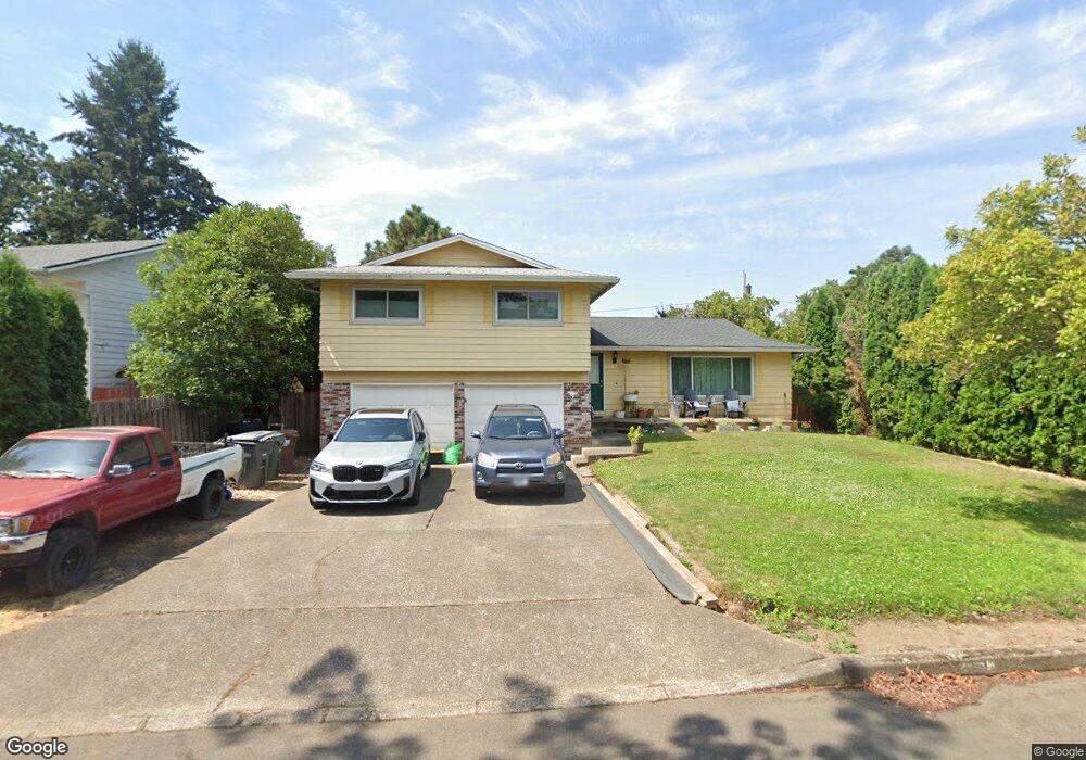
351 NE 19th Ave Hillsboro, OR 97124
Central Hillsboro NeighborhoodEstimated Value: $570,947 - $610,000
4
Beds
3
Baths
2,164
Sq Ft
$274/Sq Ft
Est. Value
About This Home
This home is located at 351 NE 19th Ave, Hillsboro, OR 97124 and is currently estimated at $592,987, approximately $274 per square foot. 351 NE 19th Ave is a home located in Washington County with nearby schools including Eastwood Elementary School, J.W. Poynter Middle School, and Liberty High School.
Ownership History
Date
Name
Owned For
Owner Type
Purchase Details
Closed on
Sep 20, 2024
Sold by
Perkins Bobbak and Smith Stacey Ella
Bought by
Perkins Bobbak and Smith Stacey E
Current Estimated Value
Home Financials for this Owner
Home Financials are based on the most recent Mortgage that was taken out on this home.
Original Mortgage
$357,286
Outstanding Balance
$351,338
Interest Rate
6.49%
Mortgage Type
New Conventional
Estimated Equity
$241,649
Purchase Details
Closed on
Jan 14, 2021
Sold by
Perkins Bobbak
Bought by
Perkins Bobbak and Smith Stacey Ella
Home Financials for this Owner
Home Financials are based on the most recent Mortgage that was taken out on this home.
Original Mortgage
$357,286
Interest Rate
2.71%
Mortgage Type
FHA
Purchase Details
Closed on
Jun 7, 2018
Sold by
Berry Michelle
Bought by
Perkins Bobbak
Home Financials for this Owner
Home Financials are based on the most recent Mortgage that was taken out on this home.
Original Mortgage
$353,479
Interest Rate
5.37%
Mortgage Type
FHA
Purchase Details
Closed on
Sep 10, 2004
Sold by
Irwin Robert Michael and Irwin Jamie E
Bought by
Berry Daniel J and Berry Michelle
Home Financials for this Owner
Home Financials are based on the most recent Mortgage that was taken out on this home.
Original Mortgage
$187,200
Interest Rate
5.94%
Mortgage Type
Unknown
Purchase Details
Closed on
Nov 18, 2002
Sold by
Stine Kermit and Stine Linda
Bought by
Irwin Robert Michael and Irwin Jamie E
Home Financials for this Owner
Home Financials are based on the most recent Mortgage that was taken out on this home.
Original Mortgage
$164,800
Interest Rate
5.89%
Mortgage Type
Balloon
Purchase Details
Closed on
May 7, 2002
Sold by
Stine Kermit A and Stine Linda R
Bought by
Stine Kermit and Stine Linda
Purchase Details
Closed on
Jul 9, 2001
Sold by
Morgan David S and Stine Kermit A
Bought by
Stine Linda R and Morgan Alice J
Create a Home Valuation Report for This Property
The Home Valuation Report is an in-depth analysis detailing your home's value as well as a comparison with similar homes in the area
Home Values in the Area
Average Home Value in this Area
Purchase History
| Date | Buyer | Sale Price | Title Company |
|---|---|---|---|
| Perkins Bobbak | -- | Lawyers Title | |
| Perkins Bobbak | -- | None Available | |
| Perkins Bobbak | $360,000 | Wfg Title | |
| Berry Daniel J | $234,000 | First American | |
| Irwin Robert Michael | $206,000 | Oregon Title Insurance Compa | |
| Stine Kermit | -- | -- | |
| Stine Linda R | -- | -- | |
| Stine Linda R | -- | -- | |
| Stine Linda R | -- | -- |
Source: Public Records
Mortgage History
| Date | Status | Borrower | Loan Amount |
|---|---|---|---|
| Open | Perkins Bobbak | $357,286 | |
| Previous Owner | Perkins Bobbak | $357,286 | |
| Previous Owner | Perkins Bobbak | $353,479 | |
| Previous Owner | Berry Daniel J | $187,200 | |
| Previous Owner | Irwin Robert Michael | $164,800 | |
| Closed | Berry Daniel J | $46,800 |
Source: Public Records
Tax History Compared to Growth
Tax History
| Year | Tax Paid | Tax Assessment Tax Assessment Total Assessment is a certain percentage of the fair market value that is determined by local assessors to be the total taxable value of land and additions on the property. | Land | Improvement |
|---|---|---|---|---|
| 2025 | $4,820 | $294,860 | -- | -- |
| 2024 | $4,683 | $286,280 | -- | -- |
| 2023 | $4,683 | $277,950 | $0 | $0 |
| 2022 | $4,556 | $277,950 | $0 | $0 |
| 2021 | $4,464 | $262,000 | $0 | $0 |
| 2020 | $4,368 | $254,370 | $0 | $0 |
| 2019 | $4,242 | $246,970 | $0 | $0 |
| 2018 | $4,061 | $239,780 | $0 | $0 |
| 2017 | $3,914 | $232,800 | $0 | $0 |
| 2016 | $3,806 | $226,020 | $0 | $0 |
| 2015 | $3,653 | $219,440 | $0 | $0 |
| 2014 | $3,632 | $213,050 | $0 | $0 |
Source: Public Records
Map
Nearby Homes
- 461 NE 16th Ave
- 2411 NE Hyde St
- 319 NE Hyde Cir
- 1303 NE Cornell Rd
- 2570 NE Grant St
- 1184 NE Turner Dr
- 1043 NE Sturgess Ave
- 1269 NE Grant St
- 1822 NE Barberry Dr
- 1112 E Main St
- 1518 SE Oak St Unit 2
- 240 SE 26th Ave
- 439 SE 24th Ave
- 349 SE Walnut St
- 3029 NE Azalea St
- 1740 NE Darby St
- 960 E Main St
- 2080 NE Darby St
- 1470 SE Walnut St Unit 210
- 166 SE 30th Ave
- 339 NE 19th Ave
- 373 NE 19th Ave
- 356 NE 18th Ave
- 366 NE 18th Ave
- 340 NE 18th Ave
- 317 NE 19th Ave
- 1892 NE Hyde St
- 368 NE 19th Ave
- 1854 NE Hyde St
- 396 NE 19th Ave
- 1838 NE Hyde St
- 326 NE 18th Ave
- 382 NE 19th Ave
- 340 NE 19th Ave
- 332 NE 19th Ave
- 1982 NE Hyde St
- 316 NE 19th Ave
- 301 NE 19th Ave
- 365 NE 18th Ave
- 343 NE 18th Ave