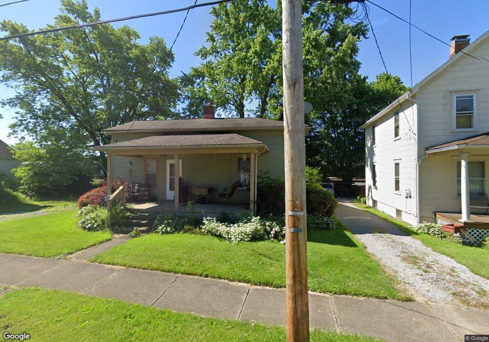
351 W Clark St East Palestine, OH 44413
Estimated Value: $50,000 - $67,000
2
Beds
1
Bath
960
Sq Ft
$62/Sq Ft
Est. Value
About This Home
This home is located at 351 W Clark St, East Palestine, OH 44413 and is currently estimated at $59,548, approximately $62 per square foot. 351 W Clark St is a home located in Columbiana County with nearby schools including East Palestine Elementary School, East Palestine Middle School, and East Palestine High School.
Ownership History
Date
Name
Owned For
Owner Type
Purchase Details
Closed on
Sep 15, 2024
Sold by
Jones Harry and Jones Kelsie
Bought by
Mcdevitt Trenton
Current Estimated Value
Purchase Details
Closed on
Nov 17, 2005
Sold by
Blower Bobby and Blower Alan
Bought by
Jones Harry
Home Financials for this Owner
Home Financials are based on the most recent Mortgage that was taken out on this home.
Original Mortgage
$31,300
Interest Rate
6.48%
Mortgage Type
Purchase Money Mortgage
Create a Home Valuation Report for This Property
The Home Valuation Report is an in-depth analysis detailing your home's value as well as a comparison with similar homes in the area
Home Values in the Area
Average Home Value in this Area
Purchase History
| Date | Buyer | Sale Price | Title Company |
|---|---|---|---|
| Mcdevitt Trenton | $49,800 | None Listed On Document | |
| Mcdevitt Trenton | $49,800 | None Listed On Document | |
| Jones Harry | $29,500 | None Available |
Source: Public Records
Mortgage History
| Date | Status | Borrower | Loan Amount |
|---|---|---|---|
| Previous Owner | Jones Harry | $31,300 |
Source: Public Records
Tax History Compared to Growth
Tax History
| Year | Tax Paid | Tax Assessment Tax Assessment Total Assessment is a certain percentage of the fair market value that is determined by local assessors to be the total taxable value of land and additions on the property. | Land | Improvement |
|---|---|---|---|---|
| 2024 | $730 | $18,800 | $3,960 | $14,840 |
| 2023 | $677 | $17,440 | $3,960 | $13,480 |
| 2022 | $658 | $17,440 | $3,960 | $13,480 |
| 2021 | $637 | $15,930 | $5,220 | $10,710 |
| 2020 | $637 | $15,930 | $5,220 | $10,710 |
| 2019 | $636 | $15,930 | $5,220 | $10,710 |
| 2018 | $603 | $14,460 | $4,730 | $9,730 |
| 2017 | $604 | $14,460 | $4,730 | $9,730 |
| 2016 | $603 | $14,350 | $4,410 | $9,940 |
| 2015 | $603 | $14,350 | $4,410 | $9,940 |
| 2014 | $594 | $14,350 | $4,410 | $9,940 |
Source: Public Records
Map
Nearby Homes
- 395 W Clark St
- 201-203 W Clark St
- 288 W North Ave
- 344 W Main St
- 115 W Taggart St
- 581 W North Ave Unit 2
- 601 W North Ave
- 377 N Market St
- 167 S Market St
- 295 E Martin St
- 681 Grandview Ave
- 199 Garfield Ave
- 684 Brookdale Ave
- 330 E Main St
- 737 Moore Ln
- 1075 Bacon Ave
- 365 Lyons Ave
- 5136 State Route 170
- 0 Bacon Ave
- 1141 Howell Ave
- 361 W Clark St
- 337 W Clark St
- 371 W Clark St
- 362 W Clark St
- 352 W Clark St
- 338 W Clark St
- 328 W Clark St
- 317 W Clark St
- 352 1/2 W Clark St
- 352 352.1/2 W Clark St W
- 372 W Clark St
- 320 W Clark St
- 407 W Clark St
- 392 W Clark St
- 297 W Clark St
- 287 Thomas St
- 289 W Clark St
- 298 W Clark St
- 409 W Clark St
- 288 W Clark St