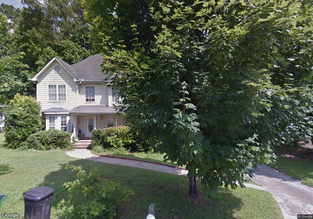
351 Winchester Way Woodstock, GA 30188
Estimated Value: $346,000 - $430,679
3
Beds
3
Baths
1,854
Sq Ft
$209/Sq Ft
Est. Value
About This Home
This home is located at 351 Winchester Way, Woodstock, GA 30188 and is currently estimated at $388,340, approximately $209 per square foot. 351 Winchester Way is a home located in Cherokee County with nearby schools including Woodstock Elementary School, Woodstock Middle School, and Woodstock High School.
Ownership History
Date
Name
Owned For
Owner Type
Purchase Details
Closed on
May 20, 2005
Sold by
Eads Gary L and Eads Linda
Bought by
Rogers Ashlei
Current Estimated Value
Home Financials for this Owner
Home Financials are based on the most recent Mortgage that was taken out on this home.
Original Mortgage
$127,840
Outstanding Balance
$65,195
Interest Rate
5.5%
Estimated Equity
$323,145
Purchase Details
Closed on
Apr 28, 1995
Sold by
Bank Of Adairsv Ille
Bought by
Bennett Linda D
Create a Home Valuation Report for This Property
The Home Valuation Report is an in-depth analysis detailing your home's value as well as a comparison with similar homes in the area
Home Values in the Area
Average Home Value in this Area
Purchase History
| Date | Buyer | Sale Price | Title Company |
|---|---|---|---|
| Rogers Ashlei | $159,800 | -- | |
| Bennett Linda D | $103,000 | -- |
Source: Public Records
Mortgage History
| Date | Status | Borrower | Loan Amount |
|---|---|---|---|
| Open | Rogers Ashlei | $127,840 | |
| Closed | Bennett Linda D | $0 |
Source: Public Records
Tax History Compared to Growth
Tax History
| Year | Tax Paid | Tax Assessment Tax Assessment Total Assessment is a certain percentage of the fair market value that is determined by local assessors to be the total taxable value of land and additions on the property. | Land | Improvement |
|---|---|---|---|---|
| 2024 | $3,206 | $144,484 | $30,000 | $114,484 |
| 2023 | $3,371 | $151,200 | $30,000 | $121,200 |
| 2022 | $2,695 | $111,476 | $23,600 | $87,876 |
| 2021 | $2,100 | $92,316 | $16,000 | $76,316 |
| 2020 | $2,513 | $86,352 | $16,000 | $70,352 |
| 2019 | $1,852 | $79,880 | $16,000 | $63,880 |
| 2018 | $1,684 | $71,000 | $12,000 | $59,000 |
| 2017 | $1,583 | $163,300 | $12,000 | $53,320 |
| 2016 | $1,459 | $148,200 | $10,800 | $48,480 |
| 2015 | $1,259 | $127,700 | $10,800 | $40,280 |
| 2014 | $1,127 | $114,800 | $9,600 | $36,320 |
Source: Public Records
Map
Nearby Homes
- 304 Winchester Way
- 1388 Chatley Way
- 1361 Chatley Way
- 403 Village View
- 315 Lakeside Ln
- 312 Thistle Ct
- 147 Hubbard Rd
- 268 Arnold Mill Rd
- 405 Nettle Ct
- The Mew Townhome Plan at Ruisseau
- 114 Parks Cir
- 419 Creekside Ln
- 776 Woodstock Grove Dr
- 444 Hathaway Ave
- 204 Melanie Ln
- 338 Cherryhill Ln
- 137 Creekview Dr
- 130 Village Trail
- 406 Creekside Ln Unit 3
- 1784 Grand Oaks Dr
- 349 Winchester Way
- 478 Springfield Dr Unit 2B
- 347 Winchester Way
- 473 Springfield Dr Unit 2B
- 345 Winchester Way Unit 2
- 476 Springfield Dr
- 474 Springfield Dr
- 471 Springfield Dr
- 472 Springfield Dr
- 336 Winchester Way Unit IIB
- 343 Winchester Way Unit 2
- 547 Rokeby Dr
- 469 Springfield Dr
- 545 Rokeby Dr
- 334 Winchester Way Unit 2B
- 543 Rokeby Dr
- 549 Rokeby Dr
- 470 Springfield Dr
- 341 Winchester Way Unit II
- 541 Rokeby Dr