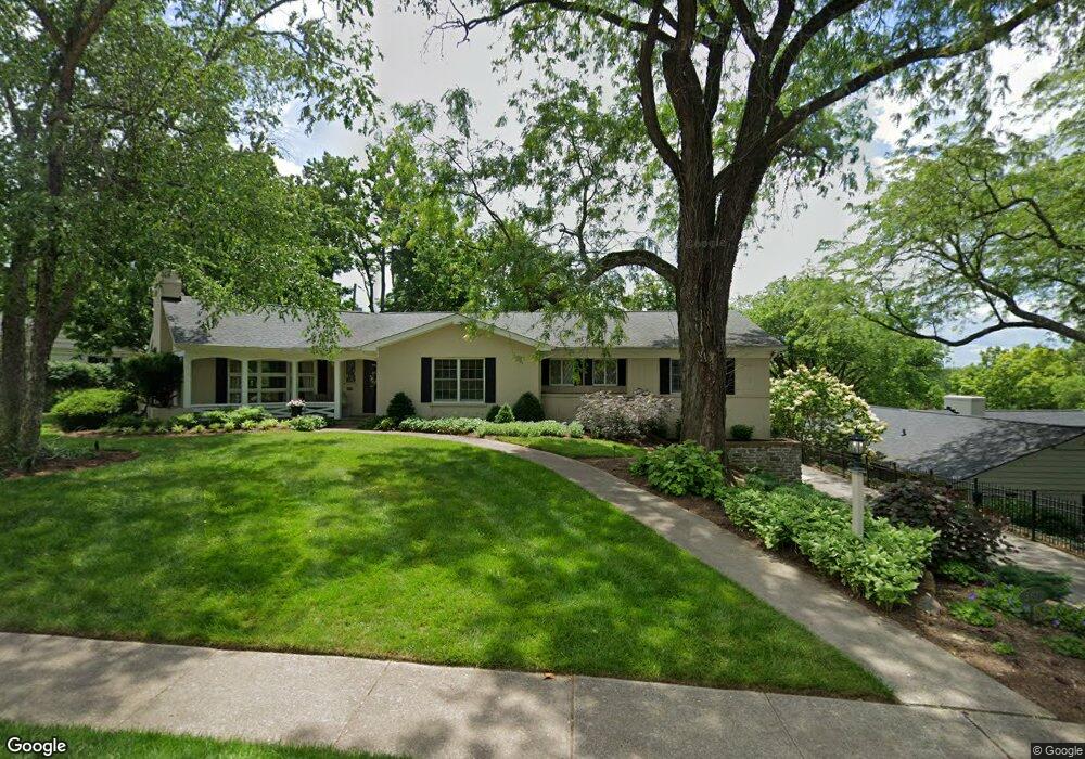
3517 Spring View Dr Cincinnati, OH 45208
Mount Lookout NeighborhoodEstimated Value: $861,000 - $1,058,000
4
Beds
3
Baths
2,256
Sq Ft
$423/Sq Ft
Est. Value
About This Home
This home is located at 3517 Spring View Dr, Cincinnati, OH 45208 and is currently estimated at $953,627, approximately $422 per square foot. 3517 Spring View Dr is a home located in Hamilton County with nearby schools including Kilgour Elementary School, Clark Montessori High School, and Shroder High School.
Ownership History
Date
Name
Owned For
Owner Type
Purchase Details
Closed on
Oct 5, 2006
Sold by
Pearce Deborah W and Pearce John N
Bought by
Freeman Louis G and Freeman Molly D
Current Estimated Value
Home Financials for this Owner
Home Financials are based on the most recent Mortgage that was taken out on this home.
Original Mortgage
$300,000
Outstanding Balance
$175,684
Interest Rate
6.5%
Mortgage Type
Unknown
Estimated Equity
$777,943
Create a Home Valuation Report for This Property
The Home Valuation Report is an in-depth analysis detailing your home's value as well as a comparison with similar homes in the area
Home Values in the Area
Average Home Value in this Area
Purchase History
| Date | Buyer | Sale Price | Title Company |
|---|---|---|---|
| Freeman Louis G | -- | Classic Title Agency Llc |
Source: Public Records
Mortgage History
| Date | Status | Borrower | Loan Amount |
|---|---|---|---|
| Open | Freeman Louis G | $300,000 |
Source: Public Records
Tax History
| Year | Tax Paid | Tax Assessment Tax Assessment Total Assessment is a certain percentage of the fair market value that is determined by local assessors to be the total taxable value of land and additions on the property. | Land | Improvement |
|---|---|---|---|---|
| 2025 | $14,062 | $238,592 | $101,938 | $136,654 |
| 2024 | $14,243 | $238,592 | $101,938 | $136,654 |
| 2023 | $14,565 | $238,592 | $101,938 | $136,654 |
| 2022 | $14,827 | $217,876 | $89,968 | $127,908 |
| 2021 | $14,271 | $217,876 | $89,968 | $127,908 |
| 2020 | $14,690 | $217,876 | $89,968 | $127,908 |
| 2019 | $13,726 | $186,218 | $76,895 | $109,323 |
| 2018 | $13,747 | $186,218 | $76,895 | $109,323 |
| 2017 | $13,060 | $186,218 | $76,895 | $109,323 |
| 2016 | $12,967 | $182,315 | $72,254 | $110,061 |
| 2015 | $11,689 | $182,315 | $72,254 | $110,061 |
| 2014 | $11,773 | $182,315 | $72,254 | $110,061 |
| 2013 | $10,793 | $164,248 | $65,093 | $99,155 |
Source: Public Records
Map
Nearby Homes
- 3608 Archer Ave
- 1134 Beverly Hill Dr
- 3643 Russell Ave
- 3645 Russell Ave
- 5087 Bouchaine Way
- 1005 Richwood Cir
- 3550 Linwood Ave
- 1002 Richwood Cir
- 5112 Shattuc Ave
- 1346 Herlin Place
- 1352 Custer Ave
- 4822 Morse St
- 3300 Linwood Ave
- 1338 Suncrest Dr
- 3443 Ault View Ave
- 3255 Linwood Ave
- 3220 Linwood Ave
- 1225 Corbett St
- 1344 Delta Ave
- 4612 Eastern Ave
- 3507 Spring View Dr
- 1216 Cliff Laine Dr
- 3525 Spring View Dr
- 1214 Cliff Laine Dr
- 1220 Cliff Laine Dr
- 4950 Healy Ct
- 3512 Spring View Dr
- 3498 Arnold St
- 3526 Spring View Dr
- 1226 Cliff Laine Dr
- 3534 Spring View Dr
- 1225 Cliff Laine Dr
- 1217 Cliff Laine Dr
- 3488 Arnold St
- 3530 Spring View Dr
- 3484 Arnold St
- 3541 Heekin Ave
- 3502 Arnold St
- 1209 Tannehill Ln
- 3585 Heekin Ave
Your Personal Tour Guide
Ask me questions while you tour the home.