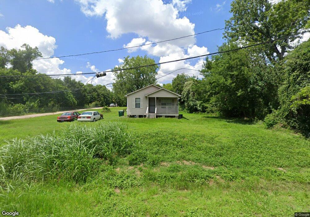
3520 Paul Quinn St Houston, TX 77091
Acres Homes NeighborhoodEstimated Value: $276,000 - $631,000
3
Beds
2
Baths
1,048
Sq Ft
$454/Sq Ft
Est. Value
About This Home
This home is located at 3520 Paul Quinn St, Houston, TX 77091 and is currently estimated at $475,899, approximately $454 per square foot. 3520 Paul Quinn St is a home located in Harris County with nearby schools including Frank Black Middle School, Scarborough High School, and KIPP Nexus Primary School.
Ownership History
Date
Name
Owned For
Owner Type
Purchase Details
Closed on
Oct 9, 2012
Sold by
Wells Fargo Bank N A
Bought by
Turner Desmond O
Current Estimated Value
Purchase Details
Closed on
Dec 16, 2011
Sold by
Moreno Juan C and Hernandez Odilia
Bought by
Wells Fargo Bank N A
Purchase Details
Closed on
Jun 6, 2006
Sold by
King Walter R and King Felisa L
Bought by
Moreno Juan C
Home Financials for this Owner
Home Financials are based on the most recent Mortgage that was taken out on this home.
Original Mortgage
$85,500
Interest Rate
8.77%
Mortgage Type
Fannie Mae Freddie Mac
Purchase Details
Closed on
Mar 27, 2004
Sold by
Walter Mortgage Co
Bought by
King Walter R
Purchase Details
Closed on
Jan 6, 2004
Sold by
Martain Rutledge Don and Martain Susan Petitt
Bought by
Walter Mortgage Co
Create a Home Valuation Report for This Property
The Home Valuation Report is an in-depth analysis detailing your home's value as well as a comparison with similar homes in the area
Home Values in the Area
Average Home Value in this Area
Purchase History
| Date | Buyer | Sale Price | Title Company |
|---|---|---|---|
| Turner Desmond O | -- | None Available | |
| Wells Fargo Bank N A | -- | None Available | |
| Moreno Juan C | -- | First American Title | |
| King Walter R | -- | -- | |
| Walter Mortgage Co | $85,365 | -- |
Source: Public Records
Mortgage History
| Date | Status | Borrower | Loan Amount |
|---|---|---|---|
| Previous Owner | Moreno Juan C | $85,500 | |
| Closed | King Walter R | $0 |
Source: Public Records
Tax History Compared to Growth
Tax History
| Year | Tax Paid | Tax Assessment Tax Assessment Total Assessment is a certain percentage of the fair market value that is determined by local assessors to be the total taxable value of land and additions on the property. | Land | Improvement |
|---|---|---|---|---|
| 2025 | $2,262 | $538,400 | $477,600 | $60,800 |
| 2024 | $2,262 | $508,793 | $477,600 | $31,193 |
| 2023 | $2,262 | $538,367 | $477,600 | $60,767 |
| 2022 | $3,397 | $343,537 | $294,520 | $49,017 |
| 2021 | $3,269 | $269,741 | $222,880 | $46,861 |
| 2020 | $3,088 | $192,841 | $143,280 | $49,561 |
| 2019 | $2,933 | $164,984 | $114,624 | $50,360 |
| 2018 | $1,936 | $143,759 | $95,520 | $48,239 |
| 2017 | $2,529 | $100,000 | $79,600 | $20,400 |
| 2016 | $3,537 | $139,899 | $79,600 | $60,299 |
| 2015 | -- | $98,000 | $63,680 | $34,320 |
| 2014 | -- | $90,144 | $31,840 | $58,304 |
Source: Public Records
Map
Nearby Homes
- 5609 Savyon Dr
- 5608 Savyon Dr
- 3402 Paul Quinn St
- 3318 Paul Quinn St
- 4702 Bayou Vista Dr
- Jefferson II Plan at Highland Grove
- 5612 Iris Harvest Dr
- 3215 Cedar Dawn Ln
- 3207 Cedar Dawn Ln
- 3422 Mansfield St
- 3414 Mansfield St
- 3406 Mansfield St
- 4906 Droddy St
- 5703 Balbo St
- 3217 Mansfield St
- 5100 Balbo St
- 6024 T C Jester Blvd
- 5810 Balbo St
- 5913 Manning Oaks St
- 5917 Manning Oaks St
- 3528 Paul Quinn St
- 5716 Paul Quinn St
- 5718 Paul Quinn St
- 5714 Paul Quinn St
- 5704 Paul Quinn St
- 5712 Paul Quinn St
- 3529 Paul Quinn St
- 5710 T c Jester Blvd
- 5623 Savyon Dr
- 5619 Savyon Dr
- 3415 Paul Quinn St
- 5617 Savyon Dr
- 1715 Paul Quinn St
- 5613 Savyon Dr
- 5622 Savyon Dr
- 5620 Savyon Dr
- 5618 Savyon Dr
- 5616 Savyon Dr
- 3410 Paul Quinn St
- RES B & C, 0 T C Jester Blvd