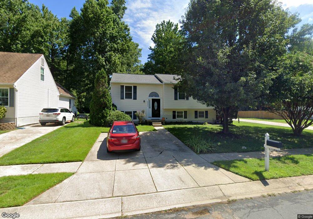
3520 River Bridge Way Laurel, MD 20724
Maryland City NeighborhoodEstimated Value: $400,000 - $527,000
Studio
2
Baths
1,084
Sq Ft
$437/Sq Ft
Est. Value
About This Home
This home is located at 3520 River Bridge Way, Laurel, MD 20724 and is currently estimated at $474,077, approximately $437 per square foot. 3520 River Bridge Way is a home located in Anne Arundel County with nearby schools including Brock Bridge Elementary School, Meade Middle School, and Meade High School.
Ownership History
Date
Name
Owned For
Owner Type
Purchase Details
Closed on
Jun 15, 2000
Sold by
Savoy James R
Bought by
Hunter Shaft S and Hunter Rosario P
Current Estimated Value
Purchase Details
Closed on
Mar 17, 1993
Sold by
Brock Bridge Ltd Ptnshp
Bought by
Savoy James R
Home Financials for this Owner
Home Financials are based on the most recent Mortgage that was taken out on this home.
Original Mortgage
$145,141
Interest Rate
7.47%
Create a Home Valuation Report for This Property
The Home Valuation Report is an in-depth analysis detailing your home's value as well as a comparison with similar homes in the area
Home Values in the Area
Average Home Value in this Area
Purchase History
| Date | Buyer | Sale Price | Title Company |
|---|---|---|---|
| Hunter Shaft S | $162,000 | -- | |
| Savoy James R | $143,400 | -- |
Source: Public Records
Mortgage History
| Date | Status | Borrower | Loan Amount |
|---|---|---|---|
| Previous Owner | Savoy James R | $145,141 |
Source: Public Records
Tax History
| Year | Tax Paid | Tax Assessment Tax Assessment Total Assessment is a certain percentage of the fair market value that is determined by local assessors to be the total taxable value of land and additions on the property. | Land | Improvement |
|---|---|---|---|---|
| 2025 | $3,046 | $369,100 | $198,900 | $170,200 |
| 2024 | $3,046 | $348,200 | $0 | $0 |
| 2023 | $2,945 | $327,300 | $0 | $0 |
| 2022 | $2,738 | $306,400 | $151,900 | $154,500 |
| 2020 | $2,608 | $295,267 | $0 | $0 |
| 2019 | $2,567 | $289,700 | $146,900 | $142,800 |
| 2018 | $2,782 | $274,367 | $0 | $0 |
| 2017 | $2,403 | $259,033 | $0 | $0 |
| 2016 | -- | $243,700 | $0 | $0 |
| 2015 | -- | $237,467 | $0 | $0 |
| 2014 | -- | $231,233 | $0 | $0 |
Source: Public Records
Map
Nearby Homes
- 11 S Carol St
- 322 Old Line Ave
- 328 Vale Summit S
- 137 Collington Place
- 6547 Clubhouse Dr
- 3352 Sudlersville S
- 183 Lyons Creek Dr
- 3341 Valley Lee S
- 1729 Mill Branch Dr
- 160 Lyons Creek Dr
- 136 Green Branch Rd
- 149 Lyons Creek Dr
- 342 Dameron S
- 341 Dameron S
- 9318 Player Dr
- 14210 Greenview Dr
- 9301 Palmer Place
- 9432 Nicklaus Ln
- 577 Brock Bridge Rd
- 3339 Crumpton S
- 3522 River Bridge Way
- 396 River Bridge Ct
- 3518 River Bridge Way
- 401 Kokomo Ct
- 397 River Bridge Ct
- 3526 River Bridge Way
- 3524 River Bridge Way
- 3521 River Bridge Way
- 3528 River Bridge Way
- 403 Kokomo Ct
- 400 Kokomo Ct
- 3530 River Bridge Way
- 405 Kokomo Ct
- 402 Kokomo Ct
- 3527 River Bridge Way
- 3532 River Bridge Way
- 407 Kokomo Ct
- 404 Kokomo Ct
- 3531 River Bridge Way
- 409 Kokomo Ct
Your Personal Tour Guide
Ask me questions while you tour the home.