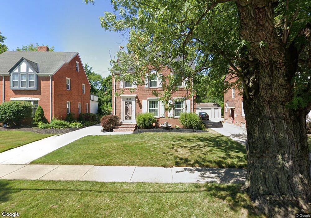
3522 Cummings Rd Cleveland Heights, OH 44118
Estimated Value: $195,000 - $255,571
3
Beds
2
Baths
1,815
Sq Ft
$124/Sq Ft
Est. Value
About This Home
This home is located at 3522 Cummings Rd, Cleveland Heights, OH 44118 and is currently estimated at $225,143, approximately $124 per square foot. 3522 Cummings Rd is a home located in Cuyahoga County with nearby schools including Canterbury Elementary School, Roxboro Middle School, and Cleveland Heights High School.
Ownership History
Date
Name
Owned For
Owner Type
Purchase Details
Closed on
Jan 21, 2025
Sold by
Gantt Paul S and Gantt Denise C
Bought by
Gantt Family Trust and Gantt
Current Estimated Value
Purchase Details
Closed on
Jun 13, 2006
Sold by
Gantt Paul S and Gantt Denise C
Bought by
Gantt Paul S and Gantt Denise C
Purchase Details
Closed on
Nov 18, 1983
Sold by
Chen Wenn Shiann and Chen E
Bought by
Gantt Paul S
Purchase Details
Closed on
Jan 1, 1975
Bought by
Chen Wenn Shiann and Chen E
Create a Home Valuation Report for This Property
The Home Valuation Report is an in-depth analysis detailing your home's value as well as a comparison with similar homes in the area
Home Values in the Area
Average Home Value in this Area
Purchase History
| Date | Buyer | Sale Price | Title Company |
|---|---|---|---|
| Gantt Family Trust | -- | None Listed On Document | |
| Gantt Paul S | -- | None Available | |
| Gantt Paul S | $47,500 | -- | |
| Chen Wenn Shiann | -- | -- |
Source: Public Records
Mortgage History
| Date | Status | Borrower | Loan Amount |
|---|---|---|---|
| Previous Owner | Gantt Paul S | $110,600 | |
| Previous Owner | Gantt Paul S | $100,000 | |
| Previous Owner | Gantt Paul S | $152,000 | |
| Previous Owner | Gantt Paul S | $50,000 | |
| Previous Owner | Gantt Paul S | $100,000 | |
| Previous Owner | Gantt Paul S | $97,000 |
Source: Public Records
Tax History Compared to Growth
Tax History
| Year | Tax Paid | Tax Assessment Tax Assessment Total Assessment is a certain percentage of the fair market value that is determined by local assessors to be the total taxable value of land and additions on the property. | Land | Improvement |
|---|---|---|---|---|
| 2024 | $5,552 | $75,250 | $14,875 | $60,375 |
| 2023 | $4,074 | $46,480 | $11,970 | $34,510 |
| 2022 | $4,098 | $46,480 | $11,970 | $34,510 |
| 2021 | $4,015 | $46,480 | $11,970 | $34,510 |
| 2020 | $3,397 | $37,490 | $9,660 | $27,830 |
| 2019 | $3,211 | $107,100 | $27,600 | $79,500 |
| 2018 | $3,212 | $37,490 | $9,660 | $27,830 |
| 2017 | $3,379 | $36,900 | $8,580 | $28,320 |
| 2016 | $3,372 | $36,900 | $8,580 | $28,320 |
| 2015 | $3,501 | $36,900 | $8,580 | $28,320 |
| 2014 | $3,501 | $39,660 | $9,210 | $30,450 |
Source: Public Records
Map
Nearby Homes
- 3499 Antisdale Ave
- 3566 Antisdale Ave
- 3575 Grosvenor Rd
- 2083 Wynn Rd Unit 3
- 2085 Wynn Rd Unit 2
- 2087 Wynn Rd Unit 1
- 1912 Janette Ave
- 3525 Raymont Blvd
- 3631 Cummings Rd
- 3521 Blanche Ave
- 3494 Raymont Blvd
- 3554 Raymont Blvd
- 3599 Blanche Ave
- 1948 Staunton Rd
- 13605 Cedar Rd
- 3484 Berkeley Rd
- 2119 Rossmoor Rd
- 2017 Goodnor Rd
- 3521 Berkeley Rd
- 1913 Staunton Rd
- 3526 Cummings Rd
- 3518 Cummings Rd
- 3514 Cummings Rd
- 3530 Cummings Rd
- 3510 Cummings Rd
- 3534 Cummings Rd
- 3506 Cummings Rd
- 3538 Cummings Rd
- 3523 Cummings Rd
- 3515 Cummings Rd
- 3519 Cummings Rd
- 3527 Cummings Rd
- 3542 Cummings Rd
- 3502 Cummings Rd
- 3507 Cummings Rd
- 3503 Cummings Rd
- 3546 Cummings Rd
- 3498 Cummings Rd
- 3541 Cummings Rd
- 3498 Antisdale Ave