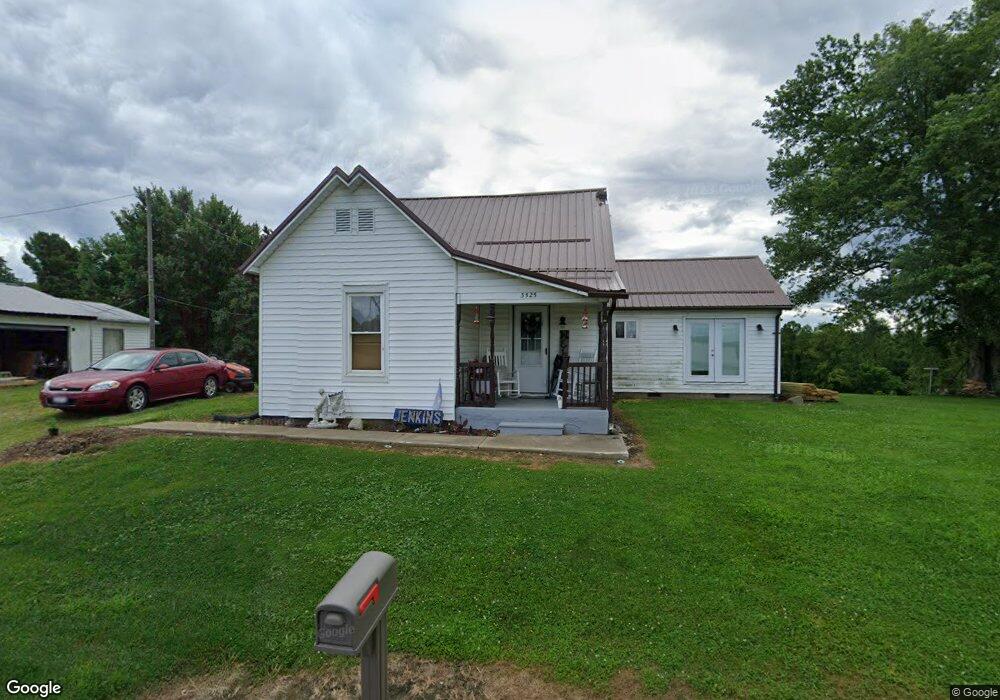
3525 State Route 792 Stockport, OH 43787
Estimated Value: $67,000 - $167,000
2
Beds
1
Bath
980
Sq Ft
$111/Sq Ft
Est. Value
About This Home
This home is located at 3525 State Route 792, Stockport, OH 43787 and is currently estimated at $108,615, approximately $110 per square foot. 3525 State Route 792 is a home located in Morgan County with nearby schools including Morgan High School.
Ownership History
Date
Name
Owned For
Owner Type
Purchase Details
Closed on
Apr 27, 2020
Sold by
Mcgrew Gretta M and Citizens National Bank Of Mcco
Bought by
Jenkins William J
Current Estimated Value
Purchase Details
Closed on
Jun 30, 2008
Sold by
Steil Debra Ann and Steil Charles R
Bought by
Mcgrew Gretta M
Home Financials for this Owner
Home Financials are based on the most recent Mortgage that was taken out on this home.
Original Mortgage
$46,815
Interest Rate
5.96%
Purchase Details
Closed on
Nov 13, 2002
Sold by
Tuttle Robert Lee
Bought by
Tuttle Myrtle Jane
Create a Home Valuation Report for This Property
The Home Valuation Report is an in-depth analysis detailing your home's value as well as a comparison with similar homes in the area
Home Values in the Area
Average Home Value in this Area
Purchase History
| Date | Buyer | Sale Price | Title Company |
|---|---|---|---|
| Jenkins William J | $27,000 | None Available | |
| Mcgrew Gretta M | -- | -- | |
| Tuttle Myrtle Jane | -- | -- |
Source: Public Records
Mortgage History
| Date | Status | Borrower | Loan Amount |
|---|---|---|---|
| Previous Owner | Mcgrew Gretta M | $46,815 |
Source: Public Records
Tax History Compared to Growth
Tax History
| Year | Tax Paid | Tax Assessment Tax Assessment Total Assessment is a certain percentage of the fair market value that is determined by local assessors to be the total taxable value of land and additions on the property. | Land | Improvement |
|---|---|---|---|---|
| 2024 | $661 | $19,930 | $7,820 | $12,110 |
| 2023 | $488 | $14,760 | $6,370 | $8,390 |
| 2022 | $492 | $14,760 | $6,370 | $8,390 |
| 2021 | $498 | $14,790 | $6,370 | $8,420 |
| 2019 | $468 | $13,550 | $5,790 | $7,760 |
| 2018 | $450 | $13,550 | $5,790 | $7,760 |
| 2017 | $436 | $12,786 | $5,002 | $7,784 |
| 2016 | $438 | $12,786 | $5,002 | $7,784 |
| 2015 | $438 | $12,821 | $5,002 | $7,819 |
| 2014 | $452 | $12,821 | $5,002 | $7,819 |
| 2013 | $707 | $12,821 | $5,002 | $7,819 |
Source: Public Records
Map
Nearby Homes
- 3265 Tieber Rd
- 681 Downing Rd
- 1715 South St
- 781 Downing Rd
- 0 Meadow St Unit Lot 9 5158299
- 0 Meadow St Unit Lot 9 225008020
- 1770 Broadway St
- 0 Downing Rd
- 1920 North St
- 1960 Broadway St
- 75 S River Rd SE
- 5174 Lightner Ridge Rd
- 3020 State Route 376
- 2444 Ervin Ln
- 2712 Sycamore Ln
- 1673 S State Route 377
- 3111 Big Bottom Ln
- 0 Kosky Dr
- 3291 Kosky Dr
- 0 Benjamin Rd
- 3450 State Route 792
- 3530 State Route 792
- 3571 Lightner Ridge Rd
- 3560 State Route 792
- 3641 Lightner Ridge Rd
- 3580 Lightner Ridge Rd
- 3537 State Route 792
- 3575 Lightner Ridge Rd
- 3927 Lightner Ridge Rd
- 3794 Lightner Ridge Rd
- 3794 Lick Run Rd
- 3980 Lightner Ridge Rd
- 3850 Lick Run Rd
- 620 E State Route 266
- 620 E State Route 266
- 3515 E State Route 266
- 338 E State Route 266
- 4000 Lightner Ridge Rd
- 265 E State Route 266
- 3592 State Route 792