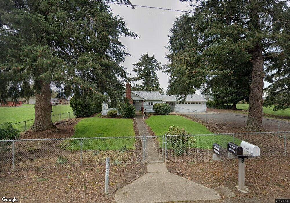
35264 Tennessee Rd SE Albany, OR 97322
Estimated Value: $461,610 - $489,000
2
Beds
1
Bath
1,136
Sq Ft
$418/Sq Ft
Est. Value
About This Home
This home is located at 35264 Tennessee Rd SE, Albany, OR 97322 and is currently estimated at $475,305, approximately $418 per square foot. 35264 Tennessee Rd SE is a home located in Linn County with nearby schools including Pioneer School and Lebanon High School.
Ownership History
Date
Name
Owned For
Owner Type
Purchase Details
Closed on
Mar 2, 2022
Sold by
Wood Robert L
Bought by
Wood Family Trust
Current Estimated Value
Purchase Details
Closed on
Dec 22, 2020
Sold by
Gardner Jessic J and Gardner Dennis J
Bought by
Knickerbocker Jonathan Richard and Knickerbocker Valerie Lynn
Home Financials for this Owner
Home Financials are based on the most recent Mortgage that was taken out on this home.
Original Mortgage
$287,878
Interest Rate
2.8%
Mortgage Type
New Conventional
Create a Home Valuation Report for This Property
The Home Valuation Report is an in-depth analysis detailing your home's value as well as a comparison with similar homes in the area
Home Values in the Area
Average Home Value in this Area
Purchase History
| Date | Buyer | Sale Price | Title Company |
|---|---|---|---|
| Wood Family Trust | $105,000 | None Listed On Document | |
| Knickerbocker Jonathan Richard | $285,000 | First American |
Source: Public Records
Mortgage History
| Date | Status | Borrower | Loan Amount |
|---|---|---|---|
| Previous Owner | Knickerbocker Jonathan Richard | $287,878 |
Source: Public Records
Tax History Compared to Growth
Tax History
| Year | Tax Paid | Tax Assessment Tax Assessment Total Assessment is a certain percentage of the fair market value that is determined by local assessors to be the total taxable value of land and additions on the property. | Land | Improvement |
|---|---|---|---|---|
| 2025 | $1,845 | $156,110 | -- | -- |
| 2024 | $1,797 | $151,570 | -- | -- |
| 2023 | $1,744 | $147,160 | $0 | $0 |
| 2022 | $1,708 | $142,880 | $0 | $0 |
| 2021 | $2,050 | $138,720 | $0 | $0 |
| 2020 | $2,008 | $134,680 | $0 | $0 |
| 2019 | $1,956 | $130,760 | $0 | $0 |
| 2018 | $1,907 | $126,960 | $0 | $0 |
| 2017 | $1,865 | $123,270 | $0 | $0 |
| 2016 | $1,821 | $119,680 | $0 | $0 |
| 2015 | $1,759 | $116,200 | $0 | $0 |
| 2014 | $1,722 | $112,820 | $0 | $0 |
Source: Public Records
Map
Nearby Homes
- 35853 Tennessee Rd SE
- 34117 Santiam Hwy
- 36162 Railroad St
- 36162 S Railroad St
- 37425 Hungry Hill Rd
- 34965 Brewster Rd
- 35628 Knox Butte Rd E
- 33510 Millview Way
- 35309 Highway 20 SE
- 33788 Brewster Rd
- 37295 Cemetery (Next To) Rd
- 515 W Mary St
- 91 W Mary St
- 180 Eaton St
- 537 W Morton St
- 59 Eaton St
- 650 Tangent St
- 36765 Glaser Dr
- 35 S Main St
- 160 Tangent St
- 35240 Tennessee Rd SE
- 35195 Tennessee Rd SE
- 35261 Tennessee Rd SE
- 35269 Tennessee Rd SE
- 35331 Tennessee Rd SE
- 35246 Tennessee Rd SE
- 35293 Tennessee Rd
- 35318 Tennessee Rd SE
- 35391 Tennessee Rd SE
- 35231 Tennessee Rd SE
- 35326 Tennessee Rd SE
- 35326 Tennessee Rd SE
- 35354 Tennessee Rd SE
- 36897 Honey Sign Dr
- 35163 Tennessee Rd
- 35168 Tennessee Rd
- 35417 Tennessee Rd SE
- 36870 Honey Sign Dr
- 36823 Honey Sign Dr
- 35440 Tennessee Rd SE