NOT LISTED FOR SALE

3527 Heritage Green Way Cookeville, TN 38506

Estimated Value: $39,000 - $209,000

3.96 Acres
$31,313 Price per Acre
172,498 Sq Ft Lot

Last Sold December 10, 2021

Last sale price $90,000

Est. 38% increase in value since last sale

Current estimated payment $667/month

Highlights

  • 3.96 Acre Lot
  • No HOA
  • Lot Has A Rolling Slope
  • Algood Elementary School Rated A-

About This Lot

As of December 2021

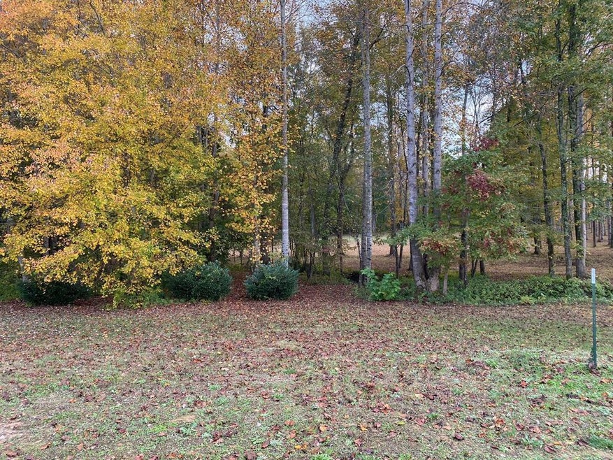
Hard to find 4+ac tract waiting for your dream home! Wonderful, upscale neighborhood with gorgeous homes all around it. Walking distance to White Plains Golf Course. Please don?t drive on the property. Also includes 3535 Heritage Green Way parcel# 041L L 056.00 , county taxes on second parcel $168.25 Buyer to verify all information.

Last Agent to Sell the Property

Amber Flynn-Jared

The Realty Firm #2 Brokerage Phone: 9315207750 License #320414 Listed on: 11/01/2021

Last Buyer's Agent

Amber Flynn-Jared

The Realty Firm #2

Property Details

Property Type

  • Land

Est. Annual Taxes

  • $169

Lot Details

  • 3.96 Acre Lot
  • Lot Has A Rolling Slope

Community Details

  • No Home Owners Association
  • Heritage Green Subdivision

Listing and Financial Details

  • Assessor Parcel Number 041L.L057.00 & 041L.L056.00

Property Details

Property Type

Land

Est. Annual Taxes

$169

Lot Details

0

Listing Details

  • Attribution Contact: 9315207750
  • Directions: From PCCH : take S Lowe Ave to E Spring St ,continue on E Spring to E Broad St, take Buck Mountain Rd to Heritage Green Way
  • Prop. Type: Land
  • Property Sub Type: Single Family Lot
  • Lot Size Acres: 3.96
  • Lot Size: irregular
  • Road Surface Type: Paved
  • Subdivision Name: Heritage Green
  • Special Features: None

Interior Features

  • Possible Use: Single Family

Exterior Features

  • Topography: Rolling
  • View: No Water Frontage View Description
  • Waterfront Features: No Water Frontage View Description

Utilities

  • Electric: UCEMC
  • Gas Company: COC
  • Electricity On Property: Yes
  • Utilities: Electricity Connected, Natural Gas Available, Sewer Available
  • Water Source: Public, Algood

Condo/Co-op/Association

  • Association: No

Lot Info

  • Lot Size Sq Ft: 172497.6
  • Farm Land Area Units: Square Feet
  • Parcel #: 041L.L057.00 & 041L.L056.00
  • Irrigation Water Rights: No

Tax Info

  • Tax Annual Amount: 168.98
  • Tax Map Number: 041L

Ownership History

Date Name Owned For Owner Type

Purchase Details

Closed on
Mar 10, 2023
Sold by
Davis Barry and Davis Shelby
Bought by
Cherry Patrick and Cherry Melissa
Current Estimated Value
$124,000

Home Financials for this Owner

Home Financials are based on the most recent Mortgage that was taken out on this home.
Original Mortgage
$117,090
Outstanding Balance
$113,388
Interest Rate
6.09%
Mortgage Type
New Conventional
Estimated Equity
$10,612

Purchase Details

Listed on
Nov 1, 2021
Closed on
Dec 10, 2021
Sold by
Jarvis William R and Jarvis Holly H
Bought by
Davis Barry and Davis Shelby
Seller's Agent
Amber Flynn-Jared
The Realty Firm #2
Buyer's Agent
Amber Flynn-Jared
The Realty Firm #2
Sold Price
$90,000

Home Financials for this Owner

Home Financials are based on the most recent Mortgage that was taken out on this home.
Avg. Annual Appreciation
8.43%
Original Mortgage
$92,479
Interest Rate
3.11%
Mortgage Type
Commercial

Purchase Details

Closed on
Feb 13, 2018
Sold by
Burgess Fam Partnership
Bought by
Jarvis William R

Purchase Details

Closed on
Aug 11, 2003
Bought by
Burgess Family Partnership

Purchase Details

Closed on
Jul 19, 1955
Bought by
Burton S D
Source: Public Records

Range of Values:

--
Value Increase
--
Percent Increase
--
Adjusted for Inflation
Collateral Analytics

Collateral Analytics Collateral Analytics AVMs (Automated Valuation Model) employ a number of statistical approaches combined with neighborhood-specific comparable selection guarantees the most up-to-date and precise valuations.

Not Available

Collateral Analytics does not have data for the current month. Please view the chart for historical values.

ICE

ICE Mortgage Technology ICE Mortgage Technology’s AVM (Automated Valuation Model) is a state-of-the-art online residential property valuation tool that provides a quick and accurate estimate of the value of almost any home in the U.S.

Not Available

ICE Mortgage Technology does not have data for the current month. Please view the chart for historical values.

First American

First American First American Data & Analytics’ next-generation AVM combines unrivaled data assets with a blended ensemble of valuation models to produce highly accurate, reliable valuations you can trust.

Not Available

First American does not have data for the current month. Please view the chart for historical values.

Quantarium

Quantarium Quantarium’s valuation service, repeatedly proven the industry’s most accurate and comprehensive, is supercharged with a self-learning and auto-tuning AI engine that continually becomes smarter and more accurate as it processes daily inputs from the industry’s leading RE data lake.

Not Available

Quantarium does not have data for the current month. Please view the chart for historical values.

Average Value
Not Available
List Price
Sold Price
Create a Home Valuation Report for This Property
The Home Valuation Report is an in-depth analysis detailing your home's value as well as a comparison with similar homes in the area

Home Values in the Area

Source: Public Records

Average Home Value in this Area


Source: Public Records

Purchase History

Date Buyer Sale Price Title Company
Cherry Patrick $115,000 Pointer Title
Davis Barry $90,000 Pointer Title Services Inc
Jarvis William R $24,000 --
Burgess Family Partnership $450,000 --
Burton S D -- --
Source: Public Records

Mortgage History

Date Status Borrower Loan Amount
Open Cherry Patrick $117,090
Previous Owner Davis Barry $92,479
Source: Public Records

Property History

Date Event Price List to Sale Price per Sq Ft
12/10/2021 12/10/21 Sold $90,000 0.0% --
01/01/1970 01/01/70 Off Market $90,000 -- --
Source: Upper Cumberland Association of REALTORS®

Tax History Compared to Growth

Source: Public Records

Tax History

Year Tax Paid Tax Assessment Tax Assessment Total Assessment is a certain percentage of the fair market value that is determined by local assessors to be the total taxable value of land and additions on the property. Land Improvement
2024 $154 $5,775 $5,775 $0
2023 $154 $5,775 $5,775 $0
2022 $143 $5,775 $5,775 $0
2021 $143 $5,775 $5,775 $0
2020 $169 $5,775 $5,775 $0
2019 $169 $5,775 $5,775 $0
2018 $158 $5,775 $5,775 $0
2017 $158 $5,775 $5,775 $0
2016 $158 $5,775 $5,775 $0
2015 $162 $5,775 $5,775 $0
2014 $154 $5,475 $0 $0
Source: Public Records

Agents Affiliated with this Home

  • Section Image
See All Agents

Map

Source: Upper Cumberland Association of REALTORS®

MLS Number: 207530

Upper Cumberland Association of REALTORS®

APN: 041L-L-057.00