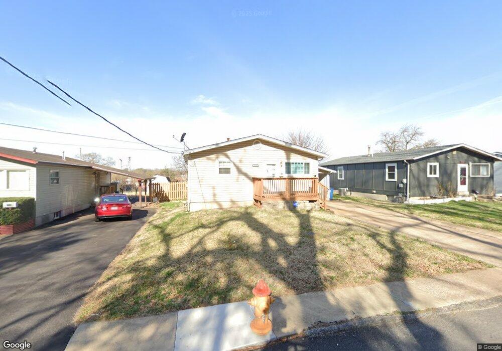
3529 Gordon Ave Saint Louis, MO 63114
Estimated Value: $145,000 - $186,000
3
Beds
2
Baths
1,040
Sq Ft
$157/Sq Ft
Est. Value
About This Home
This home is located at 3529 Gordon Ave, Saint Louis, MO 63114 and is currently estimated at $163,430, approximately $157 per square foot. 3529 Gordon Ave is a home located in St. Louis County with nearby schools including Marvin Elementary School, Ritenour Middle School, and Ritenour Senior High School.
Ownership History
Date
Name
Owned For
Owner Type
Purchase Details
Closed on
Feb 7, 2007
Sold by
Trolinger Nancy Marie
Bought by
Wilder Camille
Current Estimated Value
Home Financials for this Owner
Home Financials are based on the most recent Mortgage that was taken out on this home.
Original Mortgage
$99,900
Outstanding Balance
$67,359
Interest Rate
8.55%
Mortgage Type
Stand Alone First
Estimated Equity
$96,071
Purchase Details
Closed on
Mar 6, 1997
Sold by
Loyd Trolinger Gary
Bought by
Trolinger Nancy Marie
Create a Home Valuation Report for This Property
The Home Valuation Report is an in-depth analysis detailing your home's value as well as a comparison with similar homes in the area
Home Values in the Area
Average Home Value in this Area
Purchase History
| Date | Buyer | Sale Price | Title Company |
|---|---|---|---|
| Wilder Camille | $99,900 | Residential Title Svcs Inc | |
| Trolinger Nancy Marie | -- | -- |
Source: Public Records
Mortgage History
| Date | Status | Borrower | Loan Amount |
|---|---|---|---|
| Open | Wilder Camille | $99,900 |
Source: Public Records
Tax History Compared to Growth
Tax History
| Year | Tax Paid | Tax Assessment Tax Assessment Total Assessment is a certain percentage of the fair market value that is determined by local assessors to be the total taxable value of land and additions on the property. | Land | Improvement |
|---|---|---|---|---|
| 2025 | $2,042 | $27,780 | $5,910 | $21,870 |
| 2024 | $2,042 | $23,610 | $3,150 | $20,460 |
| 2023 | $2,002 | $23,610 | $3,150 | $20,460 |
| 2022 | $1,608 | $16,570 | $2,760 | $13,810 |
| 2021 | $1,608 | $16,570 | $2,760 | $13,810 |
| 2020 | $1,715 | $16,270 | $4,470 | $11,800 |
| 2019 | $1,696 | $16,270 | $4,470 | $11,800 |
| 2018 | $1,562 | $13,480 | $2,000 | $11,480 |
| 2017 | $1,491 | $13,480 | $2,000 | $11,480 |
| 2016 | $1,583 | $14,410 | $2,760 | $11,650 |
| 2015 | $1,619 | $14,410 | $2,760 | $11,650 |
| 2014 | $1,735 | $15,710 | $2,240 | $13,470 |
Source: Public Records
Map
Nearby Homes
- 3563 Boswell Ave
- 13 Jonell Ct
- 3562 Boswell Ave
- 3220 Marvin Ave
- 3534 Calvert Ave
- 3329 Dix Ave
- 3316 Edmundson Rd
- 3355 Edmundson Rd
- 9432 Tudor Ave
- 9060 Patrick Dr
- 9436 North Ave
- 9429 Burdella Ave
- 2812 Woodson Rd
- 9015 Mcnulty Dr
- 3219 Coles Ave
- 9422 Chester Ave
- 9047 Kathlyn Dr
- 3213 Airway Ave
- 3205 Airway Ave
- 8728 Susan Ave
- 3527 Gordon Ave
- 3531 Gordon Ave
- 3533 Gordon Ave
- 3535 Gordon Ave
- 3530 Gordon Ave
- 3536 Gordon Ave
- 3538 Gordon Ave
- 3522 Gordon Ave
- 3540 Gordon Ave
- 3541 Gordon Ave
- 3544 Gordon Ave
- 3514 Gordon Ave Unit A
- 3514 Gordon Ave
- 3543 Gordon Ave
- 3548 Gordon Ave
- 10 Jonell Ct
- 3545 Gordon Ave
- 14 Jonell Ct
- 3547 Gordon Ave
- 3512 Gordon Ave