H
Seller's Agent in 2014
Heather DAdamo
ERA One Source Realty - Stroudsburg


Estimated Value: $317,390 - $349,000
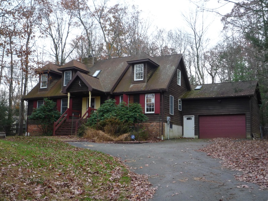
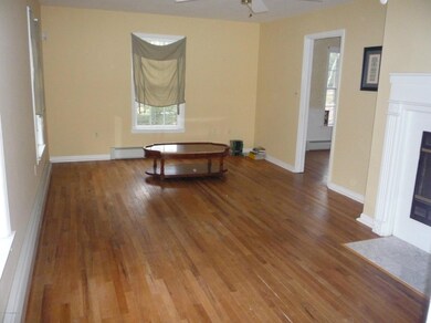
3 bed 2 bath Cape Cod. Hardwood floors, corian kitchen island, fireplace. Master suite on 1st floor. Full unfinished basement.Fenced yard, screened porch, 2 car garage. Efficient system 2000 heating system.
Sale is contingent upon seller obtaining the prior written approval of short sale lender/servicer.Home is being sold ''as is'' condition.Any clause in this agreement of sale that requires the seller to make mprovements to the property, whether due to lender requirement(s) for obtaining buyer's loan approval or due to home inspection recommendations, are hereby waived and removed from this agreement.This agreement is NOT assignable and cannot be assigned to a 3rd party with or without seller consent. Any clause contained in this agreement that refers to assignability is considered void
Short Sale Opportunity !!! All offers pending bank approval. Inspection for Buyer Knowledge Only. Property sold 'As Is '
Last Agent to Sell the Property
Heather DAdamo
ERA One Source Realty - Stroudsburg Listed on: 11/06/2013
Last Buyer's Agent
(Not in neighboring Other MLS Member
NON MEMBER
| Date | Buyer | Sale Price | Title Company |
|---|---|---|---|
| Reading Joseph | $100,000 | None Available | |
| Aul Kevin E | $218,000 | None Available |
| Date | Status | Borrower | Loan Amount |
|---|---|---|---|
| Previous Owner | Aul Kevin E | $214,051 |
| Date | Event | Price | List to Sale | Price per Sq Ft |
|---|---|---|---|---|
| 09/12/2014 09/12/14 | Sold | $100,000 | -41.1% | $55 / Sq Ft |
| 03/19/2014 03/19/14 | Pending | -- | -- | -- |
| 11/05/2013 11/05/13 | For Sale | $169,900 | -- | $93 / Sq Ft |
| Year | Tax Paid | Tax Assessment Tax Assessment Total Assessment is a certain percentage of the fair market value that is determined by local assessors to be the total taxable value of land and additions on the property. | Land | Improvement |
|---|---|---|---|---|
| 2025 | -- | $163,810 | $20,000 | $143,810 |
| 2024 | $1,076 | $163,810 | $20,000 | $143,810 |
| 2023 | $4,287 | $163,810 | $20,000 | $143,810 |
| 2022 | $4,214 | $163,810 | $20,000 | $143,810 |
| 2021 | $4,214 | $163,810 | $20,000 | $143,810 |
| 2020 | $3,761 | $163,810 | $20,000 | $143,810 |
| 2019 | $5,047 | $28,550 | $3,500 | $25,050 |
| 2018 | $5,047 | $28,550 | $3,500 | $25,050 |
| 2017 | $5,104 | $28,550 | $3,500 | $25,050 |
| 2016 | $1,185 | $28,550 | $3,500 | $25,050 |
| 2015 | -- | $28,550 | $3,500 | $25,050 |
| 2014 | -- | $28,550 | $3,500 | $25,050 |
H
Seller's Agent in 2014
Heather DAdamo
ERA One Source Realty - Stroudsburg
(
Buyer's Agent in 2014
(Not in neighboring Other MLS Member
NON MEMBER
Source: Pocono Mountains Association of REALTORS®
MLS Number: PM-6946
APN: 01.16.2.17-3
Disclaimer: Certain information contained herein is derived from information provided by parties other than Homes.com. All information provided is deemed reliable, but is not guaranteed to be accurate and should be independently verified.
![]() The data relating to real estate for sale on this web site includes listings held by MLS-IDX Participants of the Internet Data Exchange program of the Multiple Listing Service of the Pocono Mountains Association of Realtors®. Listings marked with the Internet Data Exchange logo are not necessarilty the listings of the owner of this web site. All listing data is the copyrighted property of the aforesaid Associations and its MLS-IDX Participants with all rights reserved. The information contained herein is believed to be accurate, but no warranty as such is expressed or implied.
The data relating to real estate for sale on this web site includes listings held by MLS-IDX Participants of the Internet Data Exchange program of the Multiple Listing Service of the Pocono Mountains Association of Realtors®. Listings marked with the Internet Data Exchange logo are not necessarilty the listings of the owner of this web site. All listing data is the copyrighted property of the aforesaid Associations and its MLS-IDX Participants with all rights reserved. The information contained herein is believed to be accurate, but no warranty as such is expressed or implied.