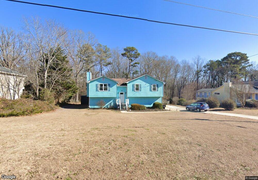
353 Woodland Path Dallas, GA 30132
East Paulding County NeighborhoodEstimated Value: $266,000 - $280,000
3
Beds
2
Baths
1,204
Sq Ft
$225/Sq Ft
Est. Value
About This Home
This home is located at 353 Woodland Path, Dallas, GA 30132 and is currently estimated at $271,073, approximately $225 per square foot. 353 Woodland Path is a home located in Paulding County with nearby schools including C. A. Roberts Elementary School, East Paulding Middle School, and East Paulding High School.
Ownership History
Date
Name
Owned For
Owner Type
Purchase Details
Closed on
May 20, 2005
Sold by
Dyer Wayne M
Bought by
Maldonado Felipe
Current Estimated Value
Home Financials for this Owner
Home Financials are based on the most recent Mortgage that was taken out on this home.
Original Mortgage
$112,730
Outstanding Balance
$58,627
Interest Rate
5.8%
Mortgage Type
VA
Estimated Equity
$212,446
Create a Home Valuation Report for This Property
The Home Valuation Report is an in-depth analysis detailing your home's value as well as a comparison with similar homes in the area
Home Values in the Area
Average Home Value in this Area
Purchase History
| Date | Buyer | Sale Price | Title Company |
|---|---|---|---|
| Maldonado Felipe | $114,500 | -- |
Source: Public Records
Mortgage History
| Date | Status | Borrower | Loan Amount |
|---|---|---|---|
| Open | Maldonado Felipe | $112,730 |
Source: Public Records
Tax History Compared to Growth
Tax History
| Year | Tax Paid | Tax Assessment Tax Assessment Total Assessment is a certain percentage of the fair market value that is determined by local assessors to be the total taxable value of land and additions on the property. | Land | Improvement |
|---|---|---|---|---|
| 2024 | $2,504 | $103,900 | $12,000 | $91,900 |
| 2023 | $2,738 | $107,548 | $12,000 | $95,548 |
| 2022 | $2,063 | $81,016 | $12,000 | $69,016 |
| 2021 | $1,779 | $63,088 | $10,000 | $53,088 |
| 2020 | $1,638 | $57,004 | $10,000 | $47,004 |
| 2019 | $1,611 | $55,328 | $10,000 | $45,328 |
| 2018 | $1,449 | $49,956 | $10,000 | $39,956 |
| 2017 | $1,501 | $51,012 | $10,000 | $41,012 |
| 2016 | $990 | $34,612 | $10,000 | $24,612 |
| 2015 | $965 | $33,224 | $10,000 | $23,224 |
| 2014 | $894 | $30,188 | $10,000 | $20,188 |
| 2013 | -- | $25,520 | $8,000 | $17,520 |
Source: Public Records
Map
Nearby Homes
- 83 Beautyberry Ln
- 108 Beautyberry Ln
- 103 Beautyberry Ln
- 58 Lost Meadows Dr
- 195 Hillside Dr
- 251 Bandimere Pkwy
- 55 Bandimere Pkwy
- Solstice Plan at Mt. Tabor Ridge
- Europa Plan at Mt. Tabor Ridge
- Splendor Plan at Mt. Tabor Ridge
- Galileo Plan at Mt. Tabor Ridge
- Copernicus Plan at Mt. Tabor Ridge
- Beacon Plan at Mt. Tabor Ridge
- Firefly Plan at Mt. Tabor Ridge
- 2576 E Paulding Dr
- 104 Hillside Dr
- 177 Antioch Church Spur
- 163 Bandimere Pkwy
- 167 Bandimere Pkwy
- 179 Bandimere Pkwy
- 353 Woodland St
- 331 Woodland Path
- 369 Woodland St
- 331 Woodland St
- 369 Woodland Path
- 303 Woodland Path
- 379 Woodland St
- 78 Meadows Ln
- 364 Woodland St
- 388 Woodland Path
- 411 Woodland St
- 77 Meadows Ln
- 408 Woodland St
- 48 Meadows Ln
- 431 Woodland St
- 271 Woodland St
- 271 Woodland St Unit 271
- 280 Woodland St
- 426 Woodland St
- 196 Lost Meadows Dr